
Faili:ElectoralCollege1872.svg

Size of this PNG preview of this SVG file: piseli 800 × 465. Ukubwa zingine: piseli 320 × 186 | piseli 640 × 372 | piseli 1,024 × 595 | piseli 1,280 × 744 | piseli 2,560 × 1,488 | piseli 1,020 × 593.
Faili halisi (faili la SVG, husemwa kuwa piseli 1,020 × 593, saizi ya faili: 80 KB)
| Faili hili linatoka Wikimedia Commons. Maelezo yapo kule kwenye ukurasa wake wa maelezo unaonekana hapo chini.
|
| U.S. presidential election maps (SVG) |
| See also: National Atlas maps (png) |
|
1789 · 1792 · 1796 · 1800 · 1804 · 1808 · 1812 · 1816 · 1820 · 1824 · 1828 · 1832 · 1836 · 1840 · 1844 · 1848 · 1852 · 1856 · 1860 · 1864 · 1868 · 1872 · 1876 · 1880 · 1884 · 1888 · 1892 · 1896 · 1900 · 1904 · 1908 · 1912 · 1916 · 1920 · 1924 · 1928 · 1932 · 1936 · 1940 · 1944 · 1948 · 1952 · 1956 · 1960 · 1964 · 1968 · 1972 · 1976 · 1980 · 1984 · 1988 · 1992 · 1996 · 2000 · 2004 · 2008 · 2012 · 2016 · 2020 · 2024 |
Muhtasari
| Maelezo |
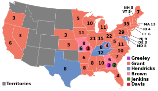
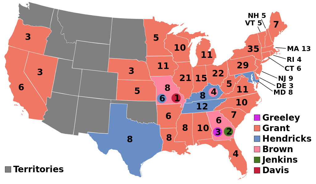
English: 1872 Electoral College |
| Chanzo | Kazi yangu |
| Mwandishi | AndyHogan14 |
Hatimiliki
| I, the copyright holder of this work, release this work into the public domain. This applies worldwide. Katika nchi zingine hii haiwezekani kisheria; kama ni hivyo: I grant anyone the right to use this work for any purpose, without any conditions, unless such conditions are required by law. |
Historia ya faili
Bonyeza tarehe/saa kuona faili kama ilivyoonekana wakati huo.
| Tarehe/Saa | Picha ndogo | Vipimo | Mtumiaji | Maelezo | |
|---|---|---|---|---|---|
| sasa hivi | 03:45, 31 Mei 2023 | | 1,020 × 593 (80 KB) | Gelid Lagopus | Reverted to version as of 04:00, 14 May 2023 (UTC) Restored more logical colors, previous colors held no basis of reason for their use |
| 23:50, 14 Mei 2023 |  | 1,020 × 593 (84 KB) | Wow | Reverted to version as of 06:19, 13 May 2023 (UTC) read COM:OVERWRITE; upload the recolored map as a separate file | |
| 04:00, 14 Mei 2023 |  | 1,020 × 593 (80 KB) | Senator Cringe LOL | Reverted to version as of 17:02, 16 April 2023 (UTC) | |
| 06:19, 13 Mei 2023 |  | 1,020 × 593 (84 KB) | Wow | Reverted to version as of 17:45, 25 May 2016 (UTC) violation of COM:OVERWRITE and en:MOS:COLOR | |
| 17:02, 16 Aprili 2023 |  | 1,020 × 593 (80 KB) | Senator Cringe LOL | More consistent Liberal Republican colors. Fixed Davis to be separated from the others. | |
| 06:30, 16 Aprili 2023 |  | 1,020 × 593 (80 KB) | Senator Cringe LOL | Simplifying colors to be more consistent with previous information (i.e. pink Greeley and traditionally Democrat Hendricks) | |
| 01:30, 15 Julai 2018 |  | 1,020 × 593 (84 KB) | Wow | Reverted to version as of 17:45, 25 May 2016 (UTC) | |
| 04:18, 20 Desemba 2016 |  | 1,020 × 593 (87 KB) | Wow | Blue | |
| 04:02, 20 Desemba 2016 |  | 1,020 × 593 (84 KB) | Wow | Reverted to version as of 17:45, 25 May 2016 (UTC) | |
| 22:17, 14 Novemba 2016 |  | 1,020 × 593 (88 KB) | Wow | Davis |
Matumizi ya faili
Ukurasa huu umeunganishwa na faili hili:
Matumizi ya faili ulimwenguni
Wiki nyingine hutumia faili hizi:
- Matumizi kwa da.wikipedia.org
- Matumizi kwa de.wikipedia.org
- Matumizi kwa el.wikipedia.org
- Matumizi kwa en.wikipedia.org
- 1872 United States presidential election
- Electoral vote changes between United States presidential elections
- List of United States presidential election results by state
- 1872 United States presidential election in California
- United States presidential election
- Presidency of Ulysses S. Grant
- Wikipedia:Graphics Lab/Illustration workshop/Archive/Nov 2011
- 1872 United States presidential election in Pennsylvania
- Template:State results of the 1872 U.S. presidential election
- 1872 United States presidential election in New York
- 1872 United States elections
- 1872 United States presidential election in Virginia
- 1872 United States presidential election in Texas
- 1872 United States presidential election in Wisconsin
- Template:1872 United States presidential election imagemap
- 1872 United States presidential election in Louisiana
- 1872 United States presidential election in Vermont
- 1872 United States presidential election in New Hampshire
- 1872 United States presidential election in Massachusetts
- 1872 United States presidential election in Connecticut
- 1872 United States presidential election in Maine
- 1872 United States presidential election in Rhode Island
- 1872 United States presidential election in New Jersey
- 1872 United States presidential election in South Carolina
- 1872 United States presidential election in Ohio
- 1872 United States presidential election in Nevada
- 1872 United States presidential election in Nebraska
- 1872 United States presidential election in Kansas
- 1872 United States presidential election in Alabama
- 1872 United States presidential election in Mississippi
- 1872 United States presidential election in Arkansas
- 1872 United States presidential election in Missouri
- 1872 United States presidential election in Tennessee
- 1872 United States presidential election in Kentucky
- 1872 United States presidential election in Georgia
- 1872 United States presidential election in Florida
- 1872 United States presidential election in Delaware
- 1872 United States presidential election in Michigan
- 1872 United States presidential election in Minnesota
- 1872 United States presidential election in West Virginia
- 1872 United States presidential election in Illinois
- 1872 United States presidential election in Indiana
- 1872 United States presidential election in Iowa
- 1872 United States presidential election in Maryland
- 1872 United States presidential election in North Carolina
- 1872 United States presidential election in Oregon
- User:DukeOfDelTaco/U.S. Presidential Elections
Tazama matumizi zaidi ya kimataifa ya faili hii.