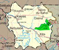
Faili:Un-mali Kayes Region.png

Yaliyomo ya ukurasa hayatumiki katika lugha nyingine.
Kutoka Wikipedia, kamusi elezo huru

Un-mali_Kayes_Region.png(piseli 692 × 594, saizi ya faili: 208 KB, aina ya MIME: image/png)

Faili hili linatoka Wikimedia Commons. Maelezo yapo kule kwenye ukurasa wake wa maelezo unaonekana hapo chini.
Commons ni mahali mtandaoni pa kuhifadhia jalada na hati za picha na sauti zenye leseni huria. Unaweza kuisadia.

Muhtasari

Maelezo Map of the Kayes Region of Mali. Additions include new northern road via Diema, several towns, downgrade of road (in fact unpaved) from Kayes to Kenieba. Solid pink lines are paved, dashed are unpaved. Addition of National park of Boucle du Baoule. Ref: Ross Velton. Mali. Bradt UK and Globe Pequot US (2005/2006) ISBN 9781841620770 Made with GIMP
Tarehe
Chanzo self-made, edit, crop, recolored, several additions to Image:Un-mali.png from http://www.un.org/Depts/Cartographic/english/htmain.htm
Mwandishi T L Miles
Ruhusa
(Kutumia faili tena)

Modified versions of UNCS maps may be used provided that the UN name and reference number does not appear on any modified version and a link to the original map is provided. Modified UN maps are to be considered in the public domain. This applies worldwide SEE:

Public domain This image is a map derived from a United Nations map.

Unless stated otherwise, UN maps are to be considered in the public domain. This applies worldwide.
Some UN maps have special copyrights, as indicated on the map itself.

UN maps are, in principle, open source material and you can use them in your work or for making your own map. UN requests however that you delete the UN name, logo and reference number upon any modification to the map. Content of your map will be your responsibility. You can state in your publication, if you wish, something like: based on UN map … (map name, map number, revision number and date). See: Geospatial Information Section. And: Geospatial, location data for a better world.

Matoleo mengine Image:Un-mali.png

Hatimiliki

Public domain I, the copyright holder of this work, release this work into the public domain. This applies worldwide.
Katika nchi zingine hii haiwezekani kisheria; kama ni hivyo:
I grant anyone the right to use this work for any purpose, without any conditions, unless such conditions are required by law.

Captions

Add a one-line explanation of what this file represents

Items portrayed in this file

depicts Kiingereza

4 Machi 2008

Historia ya faili

Bonyeza tarehe/saa kuona faili kama ilivyoonekana wakati huo.

Tarehe/SaaPicha ndogoVipimoMtumiajiMaelezo
sasa hivi18:42, 4 Machi 2008Picha ndogo ya toleo la 18:42, 4 Machi 2008692 × 594 (208 KB)T L Miles{{Information |Description=Map of the Kayes Region of Mali. Additions include new northern road via Diema, several towns, downgrade of road (in fact unpaved) from Kayes to Kenieba. Solid pink lines are paved, dashed are unpaved. Addition of National pa

Kurasa hizi 2 zimeunganishwa na faili hili:

Matumizi ya faili ulimwenguni

Wiki nyingine hutumia faili hizi: