
Faili:Tyrrhenian Sea map.png

Ukubwa wa hakikisho: piseli 440 × 600. Ukubwa zingine: piseli 176 × 240 | piseli 496 × 676.
Faili halisi (piseli 496 × 676, saizi ya faili: 127 KB, aina ya MIME: image/png)
| Faili hili linatoka Wikimedia Commons. Maelezo yapo kule kwenye ukurasa wake wa maelezo unaonekana hapo chini.
|
Muhtasari
| Maelezo |
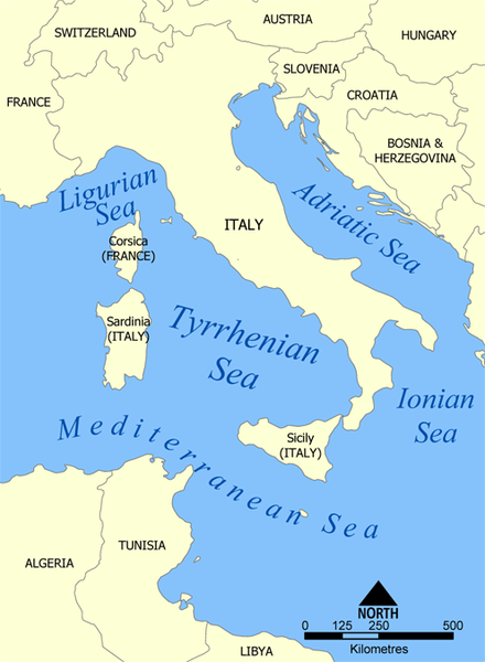
Español: Il Mar Tirreno
A map showing the location of the Tyrrhenian Sea. Created by NormanEinstein, May 19, 2005. |
| Tarehe | 19 Mei 2005 (original upload date) |
| Chanzo | No machine-readable source provided. Own work assumed (based on copyright claims). |
| Mwandishi | No machine-readable author provided. NormanEinstein assumed (based on copyright claims). |
| Matoleo mengine |
|


Hatimiliki
I, the copyright holder of this work, hereby publish it under the following licenses:

|
Ruhusa inakubalika kunakili, kusambaza na/au kurekebisha chini ya matakwa ya GNU Free Documentation License, Toleo 1.2 au toleo lolote lile la baadaye ambalo litachapishwa na Free Software Foundation; lisilo na Sehemu Tofauti, lisilo na Maandishi-Kava-Kwa-Mbele, na lisilo na Maandishi-Kava-Kwa -Nyuma. Nakala ya hatimiliki inajumlishwa kwenye sehemu ilioitwa GNU Free Documentation License. |
| Faili hii imeidhinishwa chini ya Creative Commons Attribution- Attribution-Share Alike 3.0 Unported leseni. | ||
shiriki sawa – Ukichanganya, kubadilisha, au kujenga juu ya nyenzo, lazima usambaze michango yako chini ya same or compatible license kama ya awali. | ||
| This licensing tag was added to this file as part of the GFDL licensing update. |
Unaweza kuchagua leseni ya chaguo lako.

|
This map image could be re-created using vector graphics as an SVG file. This has several advantages; see Commons:Media for cleanup for more information. If an SVG form of this image is available, please upload it and afterwards replace this template with
{{vector version available|new image name}}.
It is recommended to name the SVG file “Tyrrhenian Sea map.svg”—then the template Vector version available (or Vva) does not need the new image name parameter. |
derivative works
Derivative works of this file: Tyrrhenian Sea map ku.png Derivative works of this file: Tyrrhenian Sea map hr.svg
Historia ya faili
Bonyeza tarehe/saa kuona faili kama ilivyoonekana wakati huo.
| Tarehe/Saa | Picha ndogo | Vipimo | Mtumiaji | Maelezo | |
|---|---|---|---|---|---|
| sasa hivi | 20:25, 27 Februari 2012 | | 496 × 676 (127 KB) | Ras67 | cropped, opt |
| 20:23, 19 Mei 2005 |  | 500 × 680 (190 KB) | NormanEinstein | A map showing the location of the Tyrrhenian Sea. Created by NormanEinstein, May 19, 2005. {{PD-self}} |
Matumizi ya faili
Ukurasa huu umeunganishwa na faili hili:
Matumizi ya faili ulimwenguni
Wiki nyingine hutumia faili hizi:
- Matumizi kwa af.wikipedia.org
- Matumizi kwa ary.wikipedia.org
- Matumizi kwa azb.wikipedia.org
- Matumizi kwa ba.wikipedia.org
- Matumizi kwa be-tarask.wikipedia.org
- Matumizi kwa be.wikipedia.org
- Matumizi kwa bh.wikipedia.org
- Matumizi kwa bn.wikipedia.org
- Matumizi kwa bs.wikipedia.org
- Matumizi kwa da.wikipedia.org
- Matumizi kwa de.wikipedia.org
- Matumizi kwa de.wiktionary.org
- Matumizi kwa dsb.wikipedia.org
- Matumizi kwa el.wikipedia.org
- Matumizi kwa en.wikipedia.org
- Matumizi kwa en.wikiversity.org
- Matumizi kwa en.wiktionary.org
- Matumizi kwa eo.wikipedia.org
- Matumizi kwa es.wikipedia.org
- Matumizi kwa es.wiktionary.org
- Matumizi kwa fa.wikipedia.org
- Matumizi kwa fi.wikipedia.org
- Matumizi kwa gl.wikipedia.org
- Matumizi kwa hsb.wikipedia.org
- Matumizi kwa hyw.wikipedia.org
- Matumizi kwa id.wikipedia.org
- Matumizi kwa ilo.wikipedia.org
- Matumizi kwa is.wikipedia.org
- Matumizi kwa ja.wikipedia.org
- Matumizi kwa ka.wikipedia.org
- Matumizi kwa kk.wikipedia.org
- Matumizi kwa ko.wikipedia.org
- Matumizi kwa la.wikipedia.org
- Matumizi kwa lt.wikipedia.org
- Matumizi kwa ml.wikipedia.org
- Matumizi kwa mn.wikipedia.org
- Matumizi kwa mr.wikipedia.org
- Matumizi kwa ms.wikipedia.org
- Matumizi kwa nap.wikipedia.org
- Matumizi kwa nn.wikipedia.org
- Matumizi kwa no.wikipedia.org
- Matumizi kwa pl.wiktionary.org
Tazama matumizi zaidi ya kimataifa ya faili hii.