
Faili:Manama bahrain.jpg

Ukubwa wa hakikisho: piseli 591 × 600. Ukubwa zingine: piseli 236 × 240 | piseli 473 × 480 | piseli 757 × 768 | piseli 1,009 × 1,024 | piseli 2,017 × 2,048 | piseli 3,968 × 4,028.
Faili halisi (piseli 3,968 × 4,028, saizi ya faili: 9.65 MB, aina ya MIME: image/jpeg)
| Faili hili linatoka Wikimedia Commons. Maelezo yapo kule kwenye ukurasa wake wa maelezo unaonekana hapo chini.
|
Muhtasari
| Maelezo |
Español: Vista lateral de Bahréin desde el espacio
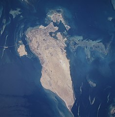
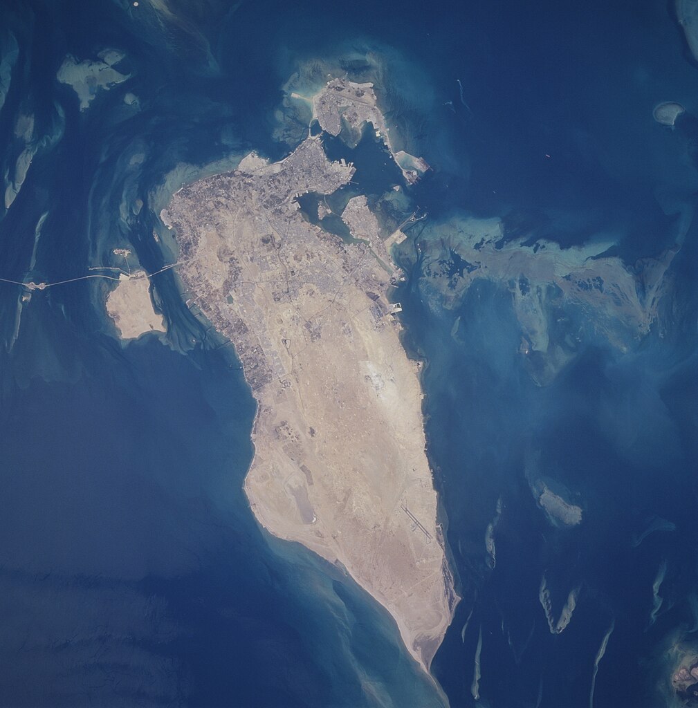
English: The capital city of Al Manamah, situated on the northeast tip of the island country of Bahrain, can be seen in this west-looking view. With a population of over 155000, Al Manamah is an international banking center with oil refineries, light industry, and is a duty free port. Tourism has also become a major industry. The main island of Bahrain is 30 miles (48 km) long north to south, and 10 miles (16 km) wide east to west. The island name comes from the Arabic word meaning "two seas". Bahrain is located 15 miles (24 km) off the eastern coast of Saudi Arabia in the Persian Gulf. The island is a low-lying barren desert with outcroppings of limestone that form low rolling hills, cliffs, and shallow ravines. The low rolling hills are called the Jabal Ad Dukhan (Mountains of Smoke) named for the mist that often wreathes the 543 foot-135 meters summit. Extending from the main island of Bahrain westward and exiting the view near the top center of the image is the causeway that connects Saudi Arabia to Bahrain. |
| Tarehe | Taken on 25 Juni 1996, 10:31:09 |
| Chanzo | https://eol.jsc.nasa.gov/SearchPhotos/photo.pl?mission=STS078&roll=748&frame=12 |
| Mwandishi | NASA/STS-78 |
| Object location | | View this and other nearby images on: OpenStreetMap |
|---|
This image or video was catalogued by Johnson Space Center of the United States National Aeronautics and Space Administration (NASA) under Photo ID: STS078-748-12. This tag does not indicate the copyright status of the attached work. A normal copyright tag is still required. See Commons:Licensing. Other languages:
|
Muhtasari
This file is in the public domain in the United States because it was created by the Image Science & Analysis Laboratory, of the NASA Johnson Space Center. NASA copyright policy states that "NASA material is not protected by copyright unless noted". (NASA media use guidelines or Conditions of Use of Astronaut Photographs).
Photo source: STS078-748-12.
|
Historia ya faili
Bonyeza tarehe/saa kuona faili kama ilivyoonekana wakati huo.
| Tarehe/Saa | Picha ndogo | Vipimo | Mtumiaji | Maelezo | |
|---|---|---|---|---|---|
| sasa hivi | 02:13, 27 Septemba 2020 | | 3,968 × 4,028 (9.65 MB) | Huntster | Full resolution from NASA. |
| 05:00, 21 Februari 2010 |  | 630 × 640 (97 KB) | Rehman | Align to North | |
| 22:40, 31 Mei 2005 |  | 640 × 630 (85 KB) | Taichi | Bahrein desde el espacio. NASA 1996 image description [http://eol.jsc.nasa.gov/sseop/EFS/photoinfo.pl?PHOTO=STS078-748-12 here] {{PD-USGov-NASA}} |
Matumizi ya faili
Hakuna kurasa zozote zinazotumia faili hii.
Matumizi ya faili ulimwenguni
Wiki nyingine hutumia faili hizi:
- Matumizi kwa af.wikipedia.org
- Matumizi kwa en.wikipedia.org
- Matumizi kwa eo.wikipedia.org
- Matumizi kwa gl.wikipedia.org
- Matumizi kwa he.wikipedia.org
- Matumizi kwa hif.wikipedia.org
- Matumizi kwa hr.wikipedia.org
- Matumizi kwa id.wikipedia.org
- Matumizi kwa lt.wikipedia.org
- Matumizi kwa ms.wikipedia.org
- Matumizi kwa pl.wikipedia.org
- Matumizi kwa ro.wikipedia.org
- Matumizi kwa sh.wikipedia.org
- Matumizi kwa simple.wikipedia.org
- Matumizi kwa tk.wikipedia.org
- Matumizi kwa uk.wikipedia.org
- Matumizi kwa zh.wikipedia.org