
Faili:Southeast Asia trade route map XIIcentury.jpg

Ukubwa wa hakikisho: piseli 706 × 599. Ukubwa zingine: piseli 283 × 240 | piseli 565 × 480 | piseli 905 × 768 | piseli 1,206 × 1,024 | piseli 1,696 × 1,440.
Faili halisi (piseli 1,696 × 1,440, saizi ya faili: 521 KB, aina ya MIME: image/jpeg)
| Faili hili linatoka Wikimedia Commons. Maelezo yapo kule kwenye ukurasa wake wa maelezo unaonekana hapo chini.
|
Muhtasari
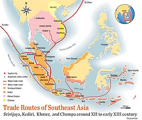
| Maelezo | Trade route map of Southeast Asia around 12th to early 13th century AD |
| Tarehe | |
| Chanzo | self-made, based from "Atlas Sejarah Indonesia dan Dunia" (Indonesian and World Historical Atlas) page 32, Drs. Achmad Jamil, Yulia Darmawaty, S.Pd, Sri Wachyuni, S.Pd, Mastara, Jakarta 2004 |
| Mwandishi | Gunawan Kartapranata |
Hatimiliki
I, the copyright holder of this work, hereby publish it under the following licenses:

|
Ruhusa inakubalika kunakili, kusambaza na/au kurekebisha chini ya matakwa ya GNU Free Documentation License, Toleo 1.2 au toleo lolote lile la baadaye ambalo litachapishwa na Free Software Foundation; lisilo na Sehemu Tofauti, lisilo na Maandishi-Kava-Kwa-Mbele, na lisilo na Maandishi-Kava-Kwa -Nyuma. Nakala ya hatimiliki inajumlishwa kwenye sehemu ilioitwa GNU Free Documentation License. |
This file is licensed under the Creative Commons Attribution-Share Alike Attribution-Share Alike 4.0 International, 3.0 Unported, 2.5 Generic, 2.0 Generic and 1.0 Generic license.
- Uko huru:
- kushiriki – kunakili na kusambaza kazi hiyo
- kwa remix – kurekebisha kazi
- Chini ya masharti yafuatayo:
- sifa – Ni lazima utoe mkopo unaofaa, utoe kiungo cha leseni, na uonyeshe ikiwa mabadiliko yalifanywa. Unaweza kufanya hivyo kwa njia yoyote inayofaa, lakini si kwa njia yoyote inayopendekeza mtoa leseni akuidhinishe wewe au matumizi yako.
Unaweza kuchagua leseni ya chaguo lako.
Historia ya faili
Bonyeza tarehe/saa kuona faili kama ilivyoonekana wakati huo.
| Tarehe/Saa | Picha ndogo | Vipimo | Mtumiaji | Maelezo | |
|---|---|---|---|---|---|
| sasa hivi | 04:19, 27 Septemba 2021 | | 1,696 × 1,440 (521 KB) | GPinkerton | Reverted to version as of 15:24, 17 August 2008 (UTC) COM:CROP |
| 13:51, 20 Oktoba 2020 |  | 1,696 × 1,440 (532 KB) | Claude Zygiel | Distinct direct territorial rule to commercial influence areas | |
| 15:24, 17 Agosti 2008 |  | 1,696 × 1,440 (521 KB) | Gunkarta | {{Information |Description= Trade route map of Southeast Asia around 12th to early 13th century AD |Source=self-made, based from "Atlas Sejarah Indonesia dan Dunia" (Indonesian and World Historical Atlas) page 32, Drs. Achmad Jamil, Yulia Darmawaty, S.Pd, | |
| 19:10, 27 Aprili 2008 |  | 1,696 × 1,440 (708 KB) | Gunkarta | {{Information |Description=Trade route map of Southeast Asia around 12th to early 13th century AD |Source=self-made, based from "Atlas Sejarah Indonesia dan Dunia" (Indonesian and World Historical Atlas) page 32, Drs. Achmad Jamil, Yulia Darmawaty, S.Pd, |
Matumizi ya faili
Hakuna kurasa zozote zinazotumia faili hii.
Matumizi ya faili ulimwenguni
Wiki nyingine hutumia faili hizi:
- Matumizi kwa azb.wikipedia.org
- Matumizi kwa ca.wikipedia.org
- Matumizi kwa cs.wikipedia.org
- Matumizi kwa da.wikipedia.org
- Matumizi kwa de.wikipedia.org
- Matumizi kwa en.wikipedia.org
- Matumizi kwa es.wikipedia.org
- Matumizi kwa fi.wikipedia.org
- Matumizi kwa fr.wikipedia.org
- Matumizi kwa he.wikipedia.org
- Matumizi kwa hr.wikipedia.org
- Matumizi kwa id.wikipedia.org
- Matumizi kwa it.wikipedia.org
- Matumizi kwa la.wikipedia.org
- Matumizi kwa ms.wikipedia.org
- Matumizi kwa pl.wikipedia.org
- Matumizi kwa ru.wikipedia.org
- Matumizi kwa sk.wikipedia.org
- Matumizi kwa su.wikipedia.org
- Matumizi kwa sv.wikipedia.org
- Matumizi kwa ta.wikipedia.org
- Matumizi kwa tt.wikipedia.org
- Matumizi kwa vi.wikipedia.org
- Matumizi kwa zh.wikipedia.org