
Faili:East Above Corniglia Cinque Terre crop Sep23 A7C 06797.jpg

Ukubwa wa hakikisho: piseli 799 × 599. Ukubwa zingine: piseli 320 × 240 | piseli 640 × 480 | piseli 1,024 × 768 | piseli 1,280 × 960 | piseli 2,560 × 1,920 | piseli 4,626 × 3,470.
Faili halisi (piseli 4,626 × 3,470, saizi ya faili: 19.17 MB, aina ya MIME: image/jpeg)
| Faili hili linatoka Wikimedia Commons. Maelezo yapo kule kwenye ukurasa wake wa maelezo unaonekana hapo chini.
|
Muhtasari
| Maelezo |
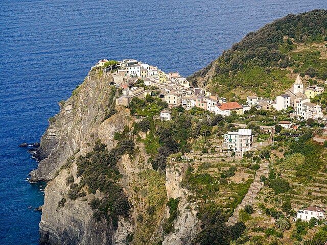
English: Corniglia perched on a 300 ft (91 m) cliff. View from the east, on Trail 587 Corniglia towards Volastra, about 260 m (850 ft) above the village. San Pietro Church middle right. Zigzag staircase down to the railway station lower right. Cinque Terre, Liguria, Italy |
|||
| Tarehe | ||||
| Chanzo | Kazi yangu | |||
| Mwandishi |
|
|||
| Matoleo mengine |
|


| Camera location | | View this and other nearby images on: OpenStreetMap |
|---|
|
The geographical information in this file was retrospectively estimated.
The location may therefore be somewhat imprecise. Verifying and refining these coordinates is strongly encouraged. |
|
This place is a UNESCO World Heritage Site, listed as
Portovenere, Cinque Terre, and the Islands (Italy).
|
Hatimiliki
I, the copyright holder of this work, hereby publish it under the following license:
This file is licensed under the Creative Commons Attribution-Share Alike 4.0 International license.
- Uko huru:
- kushiriki – kunakili na kusambaza kazi hiyo
- kwa remix – kurekebisha kazi
- Chini ya masharti yafuatayo:
- sifa – Ni lazima utoe mkopo unaofaa, utoe kiungo cha leseni, na uonyeshe ikiwa mabadiliko yalifanywa. Unaweza kufanya hivyo kwa njia yoyote inayofaa, lakini si kwa njia yoyote inayopendekeza mtoa leseni akuidhinishe wewe au matumizi yako.
Historia ya faili
Bonyeza tarehe/saa kuona faili kama ilivyoonekana wakati huo.
| Tarehe/Saa | Picha ndogo | Vipimo | Mtumiaji | Maelezo | |
|---|---|---|---|---|---|
| sasa hivi | 04:26, 22 Aprili 2024 | | 4,626 × 3,470 (19.17 MB) | Tagooty | Uploaded own work with UploadWizard |
Matumizi ya faili
Hakuna kurasa zozote zinazotumia faili hii.
Matumizi ya faili ulimwenguni
Wiki nyingine hutumia faili hizi:
- Matumizi kwa en.wikipedia.org
- Matumizi kwa frp.wikipedia.org
- Matumizi kwa fr.wikipedia.org
- Utilisateur:Min's
- Utilisateur:MG/Accueil
- Utilisateur:Wikisoft*
- Discussion utilisateur:Wikisoft*
- Wikipédia:Accueil bis
- Wikipédia:Accueil ter
- Utilisateur:MG/Tests
- Utilisateur:Fagairolles 34
- Wikipédia:Détente
- Utilisateur:Archipel
- Wikipédia:Wikimag
- Utilisateur:MG/Accueil1
- Utilisateur:MG/Accueil4
- Wikipédia:Brouillons/Accueil/3
- Utilisateur:MG/Accueil7
- Wikipédia:Image du jour
- Utilisateur:Pixeltoo/accueil
- Utilisateur:Tars
- Utilisateur:Arzach/Accueil
- Utilisateur:Arzach/Accueil/Contenu
- Utilisateur:Oz/Accueil1
- Utilisateur:Tavernier/sous1
- Utilisateur:Tavernier/sous4
- Utilisateur:Elodieleon
- Utilisateur:Sakharov/Accueil
- Utilisateur:Sakharov/Accueil2
- Utilisateur:Sakharov/Accueil3
- Utilisateur:LPLT
- Utilisateur:Jamcib/Portail
- Wikipédia:Brouillons/Accueil/1
- Utilisateur:Whistopathe/accueil
- Utilisateur:Louis-garden/Protoencours
- Utilisateur:Azerty72
- Utilisateur:EDUCA33E/Accueil
- Utilisateur:EDUCA33E/accueil
- Utilisateur:Pabix/Accueil
- Utilisateur:Quelque chose
- Utilisateur:Xinpeijin/Accueil
- Utilisateur:Xinpeijin/Projet:Rien
- Utilisateur:Hayastan07/Accueil
- Utilisateur:Jamcib/Accueil
- Utilisateur:MG/Accueil8
- Utilisateur:MG/Accueil9
- Utilisateur:DeltaWeb/test
- Utilisateur:P'tit Ju/Accueil
- Utilisateur:MG/Accueil11
- Wikipédia:Brouillons/Accueil/Test3
Tazama matumizi zaidi ya kimataifa ya faili hii.