
Faili:15th Arrondissement of Paris as seen from Pont de Bir-Hakeim 140507 1.jpg

Faili halisi (piseli 7,578 × 3,991, saizi ya faili: 13.67 MB, aina ya MIME: image/jpeg)
| Faili hili linatoka Wikimedia Commons. Maelezo yapo kule kwenye ukurasa wake wa maelezo unaonekana hapo chini.
|
Muhtasari
| Maelezo |
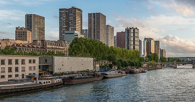
English: The 15th arrondissement of Paris as seen from the Pont de Bir-Hakeim, shortly before sunset.
Español: XV Distrito de París, Francia, visto desde el puente de Bir-Hakeim poco antes del atardecer.
|
||||
| Tarehe | |||||
| Chanzo | Kazi yangu | ||||
| Mwandishi | DXR |


| Camera location | | View this and other nearby images on: OpenStreetMap |
|---|
Assessment
|
Picha hii ilikuwa picha ya siku ya 7 Mei 2024. Maelezo mafupi yalikuwa: English: The 15th arrondissement of Paris as seen from the Pont de Bir-Hakeim, shortly before sunset Lugha nyingine:
Deutsch: Das 15. Pariser Arrondissement gesehen von der Pont de Bir-Hakeim kurz vor Sonnenuntergang. English: The 15th arrondissement of Paris as seen from the Pont de Bir-Hakeim, shortly before sunset Español: XV Distrito de París, Francia, visto desde el puente de Bir-Hakeim poco antes del atardecer. Magyar: Párizs 15. kerülete a Pont de Bir-Hakeimről nézve, röviddel naplemente előtt Nederlands: Het 15e arrondissement van de Franse hoofdstad Parijs, gezien vanaf de Pont de Bir-Hakeim Português: 15.º arrondissement de Paris, França, visto da Ponte de Bir-Hakeim pouco antes do pôr do sol. |
|
|
Panorama by DXR (Category)
The photograph above is a panoramic image which was created by me, Daniel Vorndran, and uploaded here as User:DXR.
Please note:
|


Hatimiliki
- Uko huru:
- kushiriki – kunakili na kusambaza kazi hiyo
- kwa remix – kurekebisha kazi
- Chini ya masharti yafuatayo:
- sifa – Ni lazima utoe mkopo unaofaa, utoe kiungo cha leseni, na uonyeshe ikiwa mabadiliko yalifanywa. Unaweza kufanya hivyo kwa njia yoyote inayofaa, lakini si kwa njia yoyote inayopendekeza mtoa leseni akuidhinishe wewe au matumizi yako.
Historia ya faili
Bonyeza tarehe/saa kuona faili kama ilivyoonekana wakati huo.
| Tarehe/Saa | Picha ndogo | Vipimo | Mtumiaji | Maelezo | |
|---|---|---|---|---|---|
| sasa hivi | 21:51, 3 Juni 2014 | | 7,578 × 3,991 (13.67 MB) | DXR | Selective cloud brightening top right corner |
| 13:31, 2 Juni 2014 |  | 7,578 × 3,991 (13.67 MB) | DXR | Slight straightening | |
| 13:09, 8 Mei 2014 |  | 7,595 × 4,000 (14.38 MB) | DXR | Spots removed | |
| 12:59, 8 Mei 2014 |  | 7,595 × 4,000 (14.3 MB) | DXR | VicuñaUploader 1.20 |
Matumizi ya faili
Hakuna kurasa zozote zinazotumia faili hii.
Matumizi ya faili ulimwenguni
Wiki nyingine hutumia faili hizi:
- Matumizi kwa ast.wikipedia.org
- Matumizi kwa av.wikipedia.org
- Matumizi kwa crh.wikipedia.org
- Matumizi kwa cv.wikipedia.org
- Matumizi kwa de.wikivoyage.org
- Matumizi kwa el.wikipedia.org
- Matumizi kwa en.wikivoyage.org
- Matumizi kwa es.wikipedia.org
- Matumizi kwa fr.wikipedia.org
- Matumizi kwa fr.wikivoyage.org
- Matumizi kwa hu.wikipedia.org
- Matumizi kwa hy.wikipedia.org
- Matumizi kwa id.wikipedia.org
- Matumizi kwa it.wiktionary.org
- Matumizi kwa ka.wikipedia.org
- Matumizi kwa kk.wikipedia.org
- Matumizi kwa ko.wikipedia.org
- Matumizi kwa lez.wikipedia.org
- Matumizi kwa mdf.wikipedia.org
- Matumizi kwa mk.wikipedia.org
- Matumizi kwa myv.wikipedia.org
- Matumizi kwa os.wikipedia.org
- Matumizi kwa pt.wikipedia.org
- Matumizi kwa ro.wikipedia.org
- Matumizi kwa ru.wikipedia.org
- Matumizi kwa sah.wikipedia.org
- Matumizi kwa tt.wikipedia.org
- Matumizi kwa tyv.wikipedia.org
- Matumizi kwa udm.wikipedia.org
- Matumizi kwa uk.wikipedia.org
- Matumizi kwa vep.wikipedia.org
Tazama matumizi zaidi ya kimataifa ya faili hii.