
Faili:Ancient Egypt map-en.svg

Faili halisi (faili la SVG, husemwa kuwa piseli 1,577 × 3,219, saizi ya faili: 687 KB)
| Faili hili linatoka Wikimedia Commons. Maelezo yapo kule kwenye ukurasa wake wa maelezo unaonekana hapo chini.
|
|
Muhtasari
| Maelezo |
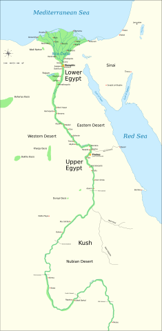
Català: Mapa de l'antic Egipte, que mostra el Nil fins a la cinquena cataracta, i les principals ciutats i llocs del període dinàstic (c. 3150 aC a 30 aC). El Caire i Jerusalem es mostren com a ciutats de referència.
English: Map of Ancient Egypt, showing the Nile up to the fifth cataract, and major cities and sites of the Dynastic period (c. 3150 BC to 30 BC). Cairo and Jerusalem are shown as reference cities. |
| Tarehe | |
| Chanzo |
Own work using:
Coordinates:
|
| Mwandishi | Jeff Dahl |
| Matoleo mengine |
File:Ancient Egypt map-en.svg has 5 translations.
Other related versions:[]
|


|
This SVG file contains embedded text that can be translated into your language, using any capable SVG editor, text editor or the SVG Translate tool. For more information see: About translating SVG files. |
This file is translated using SVG <switch> elements. All translations are stored in the same file! Learn more.
For most Wikipedia projects, you can embed the file normally (without a To translate the text into your language, you can use the SVG Translate tool. Alternatively, you can download the file to your computer, add your translations using whatever software you're familiar with, and re-upload it with the same name. You will find help in Graphics Lab if you're not sure how to do this. |
Hatimiliki

|
Ruhusa inakubalika kunakili, kusambaza na/au kurekebisha chini ya matakwa ya GNU Free Documentation License, Toleo 1.2 au toleo lolote lile la baadaye ambalo litachapishwa na Free Software Foundation; lisilo na Sehemu Tofauti, lisilo na Maandishi-Kava-Kwa-Mbele, na lisilo na Maandishi-Kava-Kwa -Nyuma. Nakala ya hatimiliki inajumlishwa kwenye sehemu ilioitwa GNU Free Documentation License. |
- Uko huru:
- kushiriki – kunakili na kusambaza kazi hiyo
- kwa remix – kurekebisha kazi
- Chini ya masharti yafuatayo:
- sifa – Ni lazima utoe mkopo unaofaa, utoe kiungo cha leseni, na uonyeshe ikiwa mabadiliko yalifanywa. Unaweza kufanya hivyo kwa njia yoyote inayofaa, lakini si kwa njia yoyote inayopendekeza mtoa leseni akuidhinishe wewe au matumizi yako.
Kumbukumbu ya upakizaji wa asili
The original description page is/was here. All following user names refer to Commons.
- 2009-01-29 13:21 Bibi Saint-Pol 1577×3219×0 (412000 bytes) (remove wrong text, adjust frame)
- 2009-01-29 12:47 Bibi Saint-Pol 1577×3219×0 (413000 bytes) (added frame)
- 2009-01-29 12:35 Bibi Saint-Pol 1577×3219×0 (412000 bytes) (harmonize colors with the standards + replace unsupported Arial fonts by DejaVu )
- 2008-02-11 06:55 Jeff Dahl 1577×3219×0 (391000 bytes) (sp fx)
- 2007-11-29 02:09 Jeff Dahl 1577×3219×0 (391000 bytes) (Rotate Mediterranean Sea label)
- 2007-11-27 23:32 Jeff Dahl 1577×3219×0 (391000 bytes) (Minor adjustments to Naukratis and Buto)
- 2007-11-27 18:59 Jeff Dahl 1577×3219×0 (391000 bytes) (Cairo and Jerusalem now with black dots/italics)
- 2007-11-23 00:04 Jeff Dahl 1577×3219×0 (391000 bytes) (fx scalebar)
- 2007-11-22 23:56 Jeff Dahl 1577×3219×0 (391000 bytes) ({{Information |Description=A map of ancient Egypt, made with Inkscape |Source=self-made |Date=11-22-07 |Author= Jeff Dahl |Permission= |other_versions={{DerivativeVersions|Ancient Egypt map-ru.svg}} }} )
Historia ya faili
Bonyeza tarehe/saa kuona faili kama ilivyoonekana wakati huo.
| Tarehe/Saa | Picha ndogo | Vipimo | Mtumiaji | Maelezo | |
|---|---|---|---|---|---|
| sasa hivi | 03:39, 20 Oktoba 2023 | | 1,577 × 3,219 (687 KB) | Haziq Faruqi | File uploaded using svgtranslate tool (https://svgtranslate.toolforge.org/). Added translation for ms. |
| 23:56, 17 Machi 2022 |  | 1,577 × 3,219 (626 KB) | Manlleus | File uploaded using svgtranslate tool (https://svgtranslate.toolforge.org/). Added translation for ca. | |
| 15:23, 6 Machi 2022 |  | 1,577 × 3,219 (564 KB) | Scratchinghead | File uploaded using svgtranslate tool (https://svgtranslate.toolforge.org/). Added translation for ta. | |
| 06:03, 25 Februari 2022 |  | 1,577 × 3,219 (564 KB) | Scratchinghead | File uploaded using svgtranslate tool (https://svgtranslate.toolforge.org/). Added translation for ta. | |
| 19:29, 6 Machi 2020 |  | 1,577 × 3,219 (501 KB) | Nilesh shukla | File uploaded using svgtranslate tool (https://tools.wmflabs.org/svgtranslate/). Added translation for hi. | |
| 11:28, 20 Februari 2009 |  | 1,577 × 3,219 (413 KB) | Bibi Saint-Pol | fix translation mistake on the windrose | |
| 12:13, 30 Januari 2009 |  | 1,577 × 3,219 (413 KB) | Bibi Saint-Pol | fix position of Nile Delta | |
| 12:21, 29 Januari 2009 |  | 1,577 × 3,219 (412 KB) | Bibi Saint-Pol | remove wrong text, adjust frame | |
| 12:05, 29 Januari 2009 |  | 1,577 × 3,219 (413 KB) | Bibi Saint-Pol | {{Assessments|1=Ancient Egypt map.svg|enwiki=1}} __NOTOC__ == {{int:filedesc}} == {{inkscape}} {{Information |Description= {{en|Map of Ancient Egypt, showing the Nile up to the fifth cataract, and major cities and sites of the Dynastic period (c. 3150 BC |
Matumizi ya faili
Hakuna kurasa zozote zinazotumia faili hii.
Matumizi ya faili ulimwenguni
Wiki nyingine hutumia faili hizi:
- Matumizi kwa anp.wikipedia.org
- Matumizi kwa azb.wikipedia.org
- Matumizi kwa blk.wikipedia.org
- Matumizi kwa bn.wikipedia.org
- Matumizi kwa bs.wikipedia.org
- Matumizi kwa ca.wikipedia.org
- Matumizi kwa ceb.wikipedia.org
- Matumizi kwa ckb.wikipedia.org
- Matumizi kwa cs.wikipedia.org
- Matumizi kwa cv.wikipedia.org
- Matumizi kwa da.wikipedia.org
- Matumizi kwa en.wikipedia.org
- Ancient Egypt
- History of Africa
- Jean-François Champollion
- Old Kingdom of Egypt
- First Intermediate Period of Egypt
- 671 BC
- Wikipedia:WikiProject Former countries
- Cradle of civilization
- Portal:Africa
- Portal:Africa/Featured article
- Portal:Africa/Featured picture
- Portal:Ancient Egypt
- Portal:Ancient Egypt/Selected picture
- Portal talk:Africa/Featured picture
- Portal:Maps/Selected picture
- Thinite Confederacy
- Portal:Africa/Featured article/2
- Wikipedia:Featured pictures thumbs/09
- Wikipedia:Picture peer review/Ancient Egypt main map
- Wikipedia:Featured picture candidates/November-2007
- Wikipedia:Featured picture candidates/Ancient Egypt map-en.svg
- Wikipedia:Wikipedia Signpost/2007-12-03/Features and admins
- Portal:Africa/Featured picture/22
- Portal:Maps/Selected picture/32
- User talk:Jeff Dahl/Archive 2
- Portal:Ancient Egypt/Selected picture/2
- User talk:Jeff Dahl/Archive 3
- Wikipedia:Picture peer review/Archives/Jul-Dec 2007
Tazama matumizi zaidi ya kimataifa ya faili hii.