Faili:Administrative divisions of Rwanda in 1994.svg

Yaliyomo ya ukurasa hayatumiki katika lugha nyingine.
Kutoka Wikipedia, kamusi elezo huru

Faili halisi(faili la SVG, husemwa kuwa piseli 1,600 × 1,400, saizi ya faili: 945 KB)

Faili hili linatoka Wikimedia Commons. Maelezo yapo kule kwenye ukurasa wake wa maelezo unaonekana hapo chini.
Commons ni mahali mtandaoni pa kuhifadhia jalada na hati za picha na sauti zenye leseni huria. Unaweza kuisadia.

Muhtasari

Maelezo
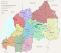
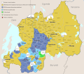
English: Administrative divisions of Rwanda in 1994.

This map can easily be customized; every commune, prefecture, and sub-prefecture has its own path which can be colored to your liking by Inkscape.

The most important sources for this map are these:

  • Guichaoua, André (August 1998) Local government in Rwanda: Expert report prepared at the request of the International Criminal Tribunal for Rwanda, ICTR Record Number: 13685, Exhibit Number: P31B in ICTR-01-74. This document contains a map of the Rwandan communes. Although the map is undated, I have been able to verify (with the map on p. 238 of Guichaoua's 2005 book called Rwanda 1994: les politiques du génocide à Butare) that the map reflects the situation in 1994; the only exception is the prefecture of Kigali-Ville which is not pictured in Guichaoua's maps even though he writes about it on page 14 of the 1998 report. I have found maps of Kigali-Ville elsewhere. It can be found, for example, at the end of of Marie Béatrice Umutesi's book Fuir ou Mourir au Zaïre
  • The lakes and roads are taken from UN maps of the period, such as Map No. 3717 Rev. 1 (November 1993) and Map No. 3717 Rev. 6 (December 1995). The roads are the same for these two maps. These maps can be found in the UN Digital Library.
  • The rivers are taken from this article: (6 July 2020). "Mapping spatio-temporal variations in water hyacinth (Eichhornia crassipes) coverage on Rwandan water bodies using multispectral imageries". International Journal of Environmental Science and Technology. DOI:10.1007/s13762-020-02824-8.
  • The subprefectures are taken from the margins of the ~40 sheets of the "Carte Pédologique du Rwanda" published in 2001, by Section des Sols Tropicaux de Pédologie, Université de Gand, Laboratoire, available at https://library.wur.nl/WebQuery/isric. This map seems to base itself on a map from 1988. The subprefectures can also be seen in an undated "Carte Touristique et Routière République Rwandaise", available at https://esdac.jrc.ec.europa.eu/ESDB_Archive/EuDASM/Africa/lists/crw.htm.
List of communes (145 communes in 11 prefectures)
  • Hyue
  • Ngoma
  • Mbazi
  • Maraba
  • Runyinya
  • Nyakizu
  • Kigembe
  • Kibayi
  • Nyaruhengeri
  • Ndora
  • Shyanda
  • Mugusa
  • Ruhashya
  • Rusatira
  • Muyaga
  • Muganza
  • Ntyazo
  • Muyira
  • Nyabisindu
  • Gishamvu
  • Ndusu
  • Gatonde
  • Nyarutovu
  • Nyamugali
  • Cyeru
  • Ruhondo
  • Cyabingo
  • Nyamutera
  • Nyakinama
  • Nkuli
  • Mukingo
  • Kinigi
  • Kigombe
  • Nkumba
  • Kidaho
  • Butaro
  • Mutura
  • Rwerere
  • Rubavu
  • Kanama
  • Nyamyumba
  • Karago
  • Giciye
  • Gaseke
  • Kayove
  • Satinsyi
  • Ramba
  • Kibilira
  • Nyarugenge
  • Kacyiru
  • Kicukiro
  • Rutongo
  • Shyorongi
  • Musasa
  • Rushashi
  • Tare
  • Mbogo
  • Mugambazi
  • Gikomero
  • Rubungo
  • Butamwa
  • Kanombe
  • Kanzenze
  • Gashora
  • Bicumbi
  • Gikoro
  • Ngenda
  • Ntongwe
  • Mugina
  • Musambira
  • Nyamabuye
  • Tambwe
  • Mukingi
  • Kigoma
  • Murama
  • Masango
  • Mushubati
  • Bulinga
  • Nyakabanda
  • Nyabikenke
  • Kayenzi
  • Rutobwe
  • Taba
  • Runda
  • Kivumu
  • Rutsiro
  • Mabanza
  • Bwakira
  • Mwendo
  • Gisovu
  • Gitesi
  • Gishyita
  • Rwamatamu
  • Gatare
  • Kirambo
  • Kagano
  • Gafunzo
  • Karengera
  • Bugarama
  • Gishoma
  • Cyimbogo
  • Kamembe
  • Gisuma
  • Nyakabuye
  • Muko
  • Musange
  • Rukondo
  • Karambo
  • Musebeya
  • Mudasomwa
  • Nyamagabe
  • Kinyamakara
  • Kivu
  • Rwamiko
  • Mubuga
  • Nshili
  • Birenga
  • Sake
  • Mugesera
  • Rukira
  • Kigarama
  • Rusumo
  • Kabarondo
  • Rutonde
  • Kayonza
  • Muhazi
  • Rukara
  • Murambi
  • Muvumba
  • Ngarama
  • Kiyombe
  • Bwisige
  • Mukarange
  • Gituza
  • Muhura
  • Giti
  • Rutare
  • Kinyami
  • Kibali
  • Buyoga
  • Cyumba
  • Kivuye
  • Cyungo
  • Tumba
  • Karama
List of subprefectures (22 in total)
  • Gisagara
  • Busoro
  • Minini
  • Karaba
  • Kaduha
  • Bugumya
  • Rwesero
  • Birambo
  • Ngororero
  • Kabaya
  • Rusengo
  • Kirambo
  • Kinihira
  • Ngarama
  • Rwamagana
  • Kirehe
  • Kanazi
  • Murambi
  • Rushashi
  • Kiyumba
  • Ruhango
  • Nyabisindu
List of prefectures (11 in total)
  • Kigali-Ville
  • Kigali-Rural
  • Byumba
  • Kibungo
  • Butare
  • Gikongoro
  • Gitarama
  • Kibuye
  • Gisenyi
  • Ruhengeri
  • Cyangugu
Tarehe
Chanzo Kazi yangu
Mwandishi Mattias Ugelvik
Matoleo mengine

Hatimiliki

I, the copyright holder of this work, hereby publish it under the following license:
w:en:Creative Commons
sifa shiriki sawa
This file is licensed under the Creative Commons Attribution-Share Alike 4.0 International license.
Uko huru:
  • kushiriki – kunakili na kusambaza kazi hiyo
  • kwa remix – kurekebisha kazi
Chini ya masharti yafuatayo:
  • sifa – Ni lazima utoe mkopo unaofaa, utoe kiungo cha leseni, na uonyeshe ikiwa mabadiliko yalifanywa. Unaweza kufanya hivyo kwa njia yoyote inayofaa, lakini si kwa njia yoyote inayopendekeza mtoa leseni akuidhinishe wewe au matumizi yako.
shiriki sawa – Ukichanganya, kubadilisha, au kujenga juu ya nyenzo, lazima usambaze michango yako chini ya same or compatible license kama ya awali.

Captions

Add a one-line explanation of what this file represents
Administrative divisions of Rwanda in 1994.

Items portrayed in this file

depicts Kiingereza

copyright status Kiingereza

copyrighted Kiingereza

5 Julai 2021

media type Kiingereza

image/svg+xml

checksum Kiingereza

780445ace6706bfdf5d87a0c97f2f0c099153d85

data size Kiingereza

967,170 Baiti

1,400 pixel

width Kiingereza

1,600 pixel

Historia ya faili

Bonyeza tarehe/saa kuona faili kama ilivyoonekana wakati huo.

Tarehe/SaaPicha ndogoVipimoMtumiajiMaelezo
sasa hivi19:29, 5 Julai 2021Picha ndogo ya toleo la 19:29, 5 Julai 20211,600 × 1,400 (945 KB)UglematUploaded own work with UploadWizard

Ukurasa huu umeunganishwa na faili hili:

Matumizi ya faili ulimwenguni

Wiki nyingine hutumia faili hizi:

Data juu