
Faili:California US Congressional District 25 (since 2013).tif

Size of this PNG preview of this TIF file: piseli 800 × 396. Ukubwa zingine: piseli 320 × 158 | piseli 640 × 317 | piseli 1,024 × 507 | piseli 2,016 × 998.
Faili halisi (piseli 2,016 × 998, saizi ya faili: 2.69 MB, aina ya MIME: image/tiff)
| Faili hili linatoka Wikimedia Commons. Maelezo yapo kule kwenye ukurasa wake wa maelezo unaonekana hapo chini.
|
Muhtasari
| Maelezo |
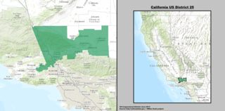
English: Map of the 25th Congressional District, representing part of northern Los Angeles County and part of eastern Ventura County, in Southern California.
Español: Mapa del 25.º Distrito Congresional de California— en Condados de Los Angeles y Ventura. |
| Tarehe | |
| Chanzo | GIS shapefile data created by the United States Department of the Interior, as part of the "1 Million Scale" geospatial data project. Retrieved from: http://nationalatlas.gov/atlasftp-1m.html?openChapters=#chpbound |
| Mwandishi | 1: GIS (congressional districts, 2013) shapefile data was created by the United States Department of the Interior. 2: Data was rendered using ArcGIS® software by Esri. 3: File developed for use on Wikipedia and elsewhere by 7partparadigm. |
Hatimiliki
This map was obtained from an edition of the National Atlas of the United States. Like almost all works of the U.S. federal government, works from the National Atlas are in the public domain in the United States.
Online access: NationalAtlas.gov | 1970 print edition: Library of Congress, Perry-Castañeda Library
|
en:California's 25th congressional district es:25.º distrito congresional de California
Historia ya faili
Bonyeza tarehe/saa kuona faili kama ilivyoonekana wakati huo.
| Tarehe/Saa | Picha ndogo | Vipimo | Mtumiaji | Maelezo | |
|---|---|---|---|---|---|
| sasa hivi | 03:18, 22 Machi 2014 | 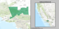 | 2,016 × 998 (2.69 MB) | 7partparadigm | User created page with UploadWizard |
Matumizi ya faili
Hakuna kurasa zozote zinazotumia faili hii.
Matumizi ya faili ulimwenguni
Wiki nyingine hutumia faili hizi:
- Matumizi kwa en.wikipedia.org
- Matumizi kwa fr.wikipedia.org
- Matumizi kwa hu.wikipedia.org
- Matumizi kwa tr.wikipedia.org
- Matumizi kwa www.wikidata.org
- Matumizi kwa zh.wikipedia.org