
Faili:Brazil 16thc map.jpg

Ukubwa wa hakikisho: piseli 800 × 561. Ukubwa zingine: piseli 320 × 224 | piseli 640 × 448 | piseli 1,024 × 717 | piseli 1,280 × 897 | piseli 2,560 × 1,794 | piseli 14,028 × 9,829.
Faili halisi (piseli 14,028 × 9,829, saizi ya faili: 33.51 MB, aina ya MIME: image/jpeg)
| Faili hili linatoka Wikimedia Commons. Maelezo yapo kule kwenye ukurasa wake wa maelezo unaonekana hapo chini.
|
|
Muhtasari
| Warning | The original file is very high-resolution. It might not load properly or could cause your browser to freeze when opened at full size. |
|---|
| Title |
[Atlas nautique du Monde, dit atlas Miller] ; 2-5. [Atlas Miller : feuilles 2 à 5 ]. feuille 5 |
||||||||||||||||||||||||||
| Description |
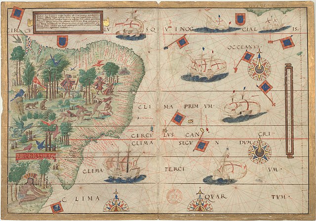
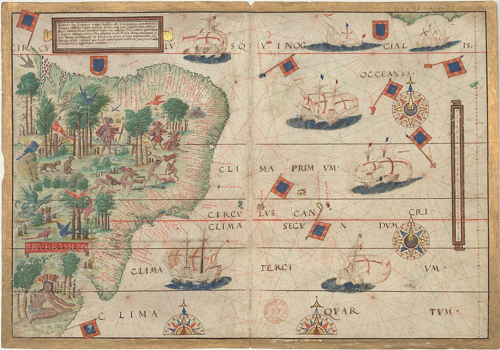
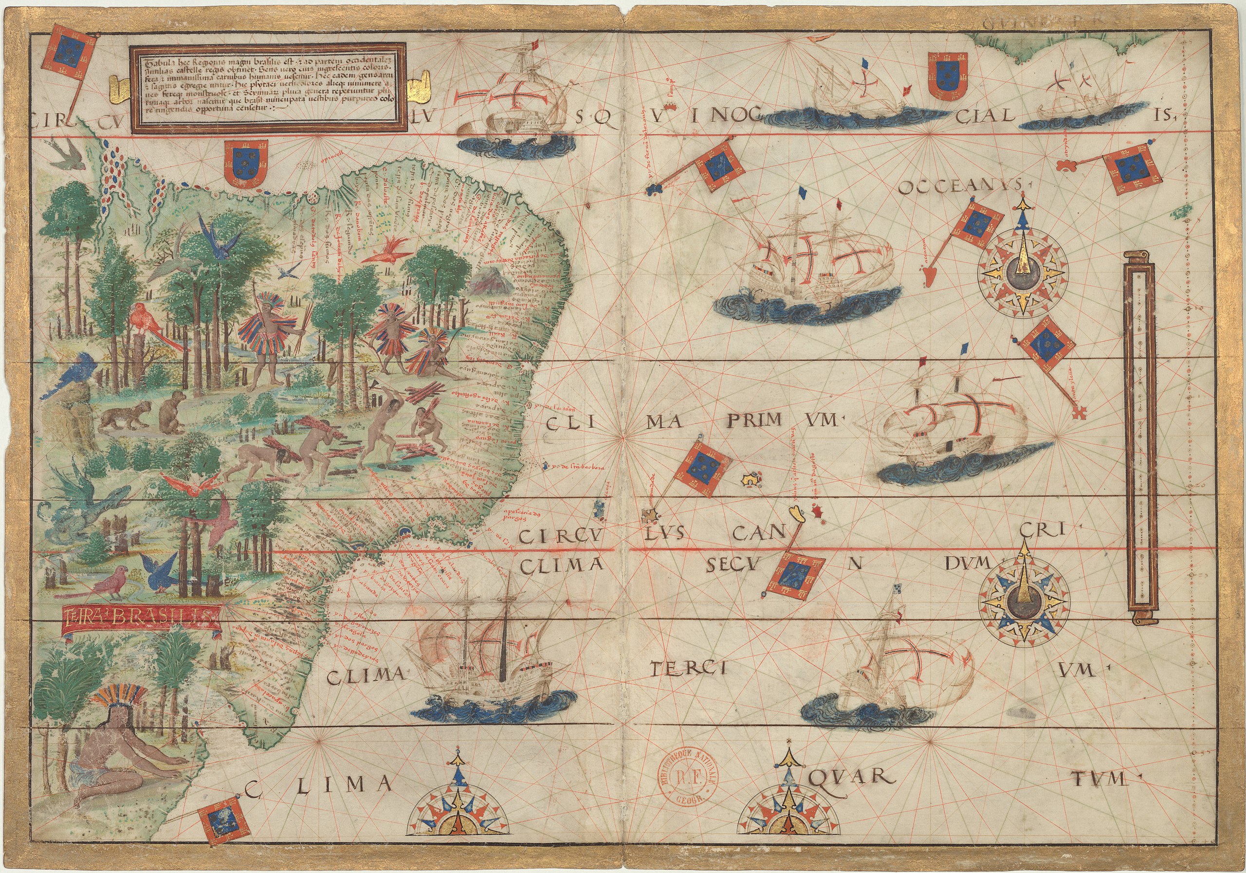
English: Map of Brazil in the Miller Atlas of 1519. |
||||||||||||||||||||||||||
| Tarehe | |||||||||||||||||||||||||||
| Chanzo |
Bibliothèque nationale de France |
||||||||||||||||||||||||||
| Muumbaji |
|
||||||||||||||||||||||||||
| Georeferencing | If inappropriate please set warp_status = skip to hide. | ||||||||||||||||||||||||||
| Archival data | |||||||||||||||||||||||||||
| Collection |
|
||||||||||||||||||||||||||
| Dimensions | Urefu: 42 cm; Upana: 59 cm | ||||||||||||||||||||||||||
| Matoleo mengine |
 |
||||||||||||||||||||||||||


Hatimiliki
|
This is a faithful photographic reproduction of a two-dimensional, public domain work of art. The work of art itself is in the public domain for the following reason:
The official position taken by the Wikimedia Foundation is that "faithful reproductions of two-dimensional public domain works of art are public domain".
This photographic reproduction is therefore also considered to be in the public domain in the United States. In other jurisdictions, re-use of this content may be restricted; see Reuse of PD-Art photographs for details. | ||||
Historia ya faili
Bonyeza tarehe/saa kuona faili kama ilivyoonekana wakati huo.
| Tarehe/Saa | Picha ndogo | Vipimo | Mtumiaji | Maelezo | |
|---|---|---|---|---|---|
| sasa hivi | 22:08, 21 Machi 2021 | | 14,028 × 9,829 (33.51 MB) | Giro720 | full size map |
| 17:19, 18 Julai 2007 |  | 1,500 × 1,059 (1.21 MB) | Sebastian Wallroth | {{Information |Description={{en|Miller Atlas from 1519 by Pedro Reinel, Jorge Reinel, Lopo Homem (mapmakers), and António de Holanda (miniaturist).}}{{de|Miller Atlas von 1519 von Pedro und Jorge Reinel, Lopo Homem (Kartograp | |
| 09:43, 20 Januari 2006 |  | 400 × 543 (93 KB) | Pedro Aguiar | Colonial map of Brazil, early 16th century. |
Matumizi ya faili
Hakuna kurasa zozote zinazotumia faili hii.
Matumizi ya faili ulimwenguni
Wiki nyingine hutumia faili hizi:
- Matumizi kwa als.wikipedia.org
- Matumizi kwa ca.wikipedia.org
- Matumizi kwa de.wikipedia.org
- Matumizi kwa de.wikisource.org
- Matumizi kwa en.wikipedia.org
- Latin America
- History of Portugal
- Coronelism
- Cangaço
- Milk coffee politics
- Federative units of Brazil
- Colonial Brazil
- First Brazilian Republic
- Wikipedia:Featured picture candidates
- Vargas Era
- Captaincies of Brazil
- Bandeirantes
- Template:History of Brazil
- Fourth Brazilian Republic
- List of mayors of Rio de Janeiro
- Military dictatorship in Brazil
- France Antarctique
- Equinoctial France
- Letter of Pero Vaz de Caminha
- Palmares (quilombo)
- Sierra de la Plata
- Fernão de Loronha
- History of Brazil (1985–present)
- Mensalão scandal
- User:Yug/History: Latin America
- Economic history of Portugal
- Civilizing mission
- Portal:Portugal
- Dutch Brazil
- Pedro Reinel
- 1964 Brazilian coup d'état
- Wikipedia:Userboxes/History
- Marajoara culture
- Name of Brazil
- Slavery in Brazil
- User:Mizunoryu
- History of Brazil
- Transfer of the Portuguese court to Brazil
- History of the Empire of Brazil
- Kuhikugu
- Lopo Homem
- Bernardo Vieira de Melo
Tazama matumizi zaidi ya kimataifa ya faili hii.