
Faili:RomaniaBorderHistoryAnnimation 1859-2010.gif
Ukubwa wa hakikisho: piseli 696 × 599. Ukubwa zingine: piseli 279 × 240 | piseli 558 × 480 | piseli 1,000 × 861.
Faili halisi (piseli 1,000 × 861, saizi ya faili: 162 KB, aina ya MIME: image/gif, looped, 12 frames, 36 s)
| Faili hili linatoka Wikimedia Commons. Maelezo yapo kule kwenye ukurasa wake wa maelezo unaonekana hapo chini.
|
Muhtasari
| Maelezo |
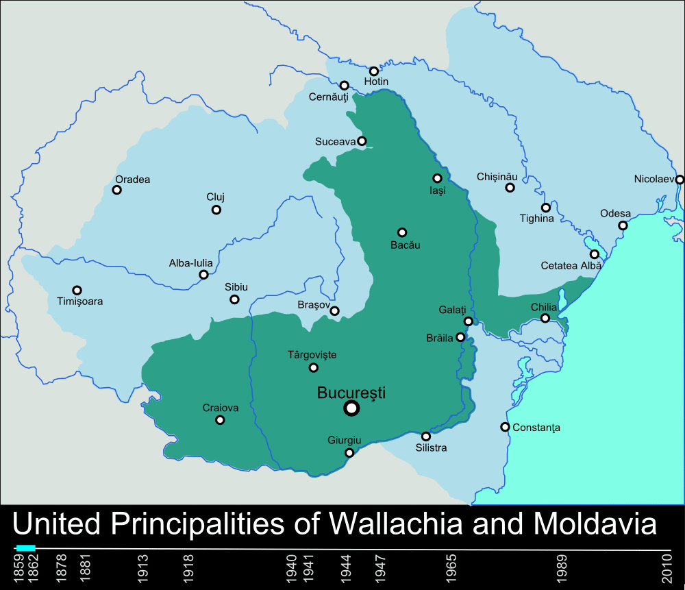
English: Timeline of the borders of Romania between 1859 and 2010. |
| Tarehe | 11 Januari 2010 (original upload date) |
| Chanzo | self-made, individual frames were based on maps from here: Atlas of Romania. (I could upload standalone maps for each period of time, if needed. Contact me for that.). |
| Mwandishi | User:Scooter20 |
| Matoleo mengine | Derivative works of this file: RomaniaBorderHistoryAnnimation 1859-2010 es.gif |
Hatimiliki
| This work has been released into the public domain by its author, Scooter20 at Kiingereza Wikipedia. This applies worldwide. Katika nchi zingine hii haiwezekani kisheria; kama ni hivyo: Scooter20 grants anyone the right to use this work for any purpose, without any conditions, unless such conditions are required by law. |
Kumbukumbu ya upakizaji wa asili
Transferred from en.wikipedia to Commons by Rowanwindwhistler using CommonsHelper.
The original description page was here. All following user names refer to en.wikipedia.
- 2010-01-11 22:17 Scooter20 1000×861× (166899 bytes) Reverted to version as of 12:48, 31 December 2009
- 2010-01-10 21:53 Alexandrey 1000×861× (152174 bytes) Reverted to version as of 19:31, 30 December 2009
- 2010-01-10 21:52 Alexandrey 1000×861× (166932 bytes) Reverted to version as of 12:29, 31 December 2009
- 2009-12-31 12:48 Scooter20 1000×861× (166899 bytes) fixed Hertza region, which didn't belong to Romania after 1944
- 2009-12-31 12:29 Scooter20 1000×861× (166932 bytes) Added new intervals: 1862-1878, 1878-1881 - United Romanian Principalities 1947-1965 - People's Republic of Romania
- 2009-12-31 00:57 Scooter20 1000×861× (153234 bytes) fixed location of the city of Sibiu
- 2009-12-30 19:31 Scooter20 1000×861× (152174 bytes) Timeline of the borders of Romania between 1859 and 2010.
Historia ya faili
Bonyeza tarehe/saa kuona faili kama ilivyoonekana wakati huo.
| Tarehe/Saa | Picha ndogo | Vipimo | Mtumiaji | Maelezo | |
|---|---|---|---|---|---|
| sasa hivi | 22:02, 9 Machi 2012 | | 1,000 × 861 (162 KB) | Scooter20 | Better colors! |
| 16:07, 8 Septemba 2010 |  | 1,000 × 861 (168 KB) | Mihai Andrei | Corrected the name of the city of Cluj for the period until 1975. | |
| 00:09, 4 Septemba 2010 |  | 1,000 × 861 (163 KB) | Anonimizat XXX | (I tried to revert to the version from april 2010 but it didn't work, so I've decided to manually upload again) | |
| 00:02, 4 Septemba 2010 |  | 1,000 × 861 (163 KB) | Anonimizat XXX | Reverted to version as of 20:45, 21 April 2010 (animation broken, also, the name of Cluj is actually Cluj-Napoca as the original gif indicate) | |
| 18:02, 9 Agosti 2010 |  | 1,000 × 861 (73 KB) | Mihai Andrei | Corrected the name of the city of Cluj. | |
| 20:45, 21 Aprili 2010 |  | 1,000 × 861 (163 KB) | File Upload Bot (Magnus Manske) | {{BotMoveToCommons|en.wikipedia|year={{subst:CURRENTYEAR}}|month={{subst:CURRENTMONTHNAME}}|day={{subst:CURRENTDAY}}}} {{Information |Description={{en|Timeline of the borders of Romania between 1859 and 2010.<br/> == Other versions == [[:en:Image:Flag_of |
Matumizi ya faili
Ukurasa huu umeunganishwa na faili hili:
Matumizi ya faili ulimwenguni
Wiki nyingine hutumia faili hizi:
- Matumizi kwa af.wikipedia.org
- Matumizi kwa ar.wikipedia.org
- Matumizi kwa ary.wikipedia.org
- Matumizi kwa ast.wikipedia.org
- Matumizi kwa azb.wikipedia.org
- Matumizi kwa bcl.wikipedia.org
- Matumizi kwa da.wikipedia.org
- Matumizi kwa de.wikipedia.org
- Matumizi kwa el.wikipedia.org
- Matumizi kwa en.wikipedia.org
- Matumizi kwa et.wikipedia.org
- Matumizi kwa eu.wikipedia.org
- Matumizi kwa fa.wikipedia.org
- Matumizi kwa fi.wikipedia.org
- Matumizi kwa it.wikipedia.org
- Matumizi kwa ja.wikipedia.org
- Matumizi kwa ka.wikipedia.org
- Matumizi kwa lv.wikipedia.org
- Matumizi kwa mk.wikipedia.org
- Matumizi kwa no.wikipedia.org
- Matumizi kwa pt.wikipedia.org
- Matumizi kwa ro.wikibooks.org
- Matumizi kwa ru.wikipedia.org
- Matumizi kwa sl.wikipedia.org
Tazama matumizi zaidi ya kimataifa ya faili hii.