Faili:Makambako.png

Yaliyomo ya ukurasa hayatumiki katika lugha nyingine.
Kutoka Wikipedia, kamusi elezo huru

Faili halisi(piseli 538 × 610, saizi ya faili: 716 KB, aina ya MIME: image/png)

Faili hili linatoka Wikimedia Commons. Maelezo yapo kule kwenye ukurasa wake wa maelezo unaonekana hapo chini.
Commons ni mahali mtandaoni pa kuhifadhia jalada na hati za picha na sauti zenye leseni huria. Unaweza kuisadia.

Muhtasari

This map image could be re-created using vector graphics as an SVG file. This has several advantages; see Commons:Media for cleanup for more information. If an SVG form of this image is available, please upload it and afterwards replace this template with {{vector version available|new image name}}.


It is recommended to name the SVG file “Makambako.svg”—then the template Vector version available (or Vva) does not need the new image name parameter.
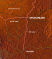
Maelezo Map of Makambako, Njombe District, Tanzania
Tarehe
Chanzo http://www.maps-for-free.com/
Mwandishi Modified by Dr. Blofeld
Ruhusa
(Kutumia faili tena)
http://www.maps-for-free.com/html/about.html

Hatimiliki

This screenshot either does not contain copyright-eligible parts or visuals of copyrighted software, or the author has released it under a free license (which should be indicated beneath this notice), and as such follows the licensing guidelines for screenshots of Wikimedia Commons. You may use it freely according to its particular license. Free software license:

GNU head

This work is free software; you can redistribute it and/or modify it under the terms of the GNU General Public License as published by the Free Software Foundation; either version 2 of the License, or any later version. This work is distributed in the hope that it will be useful, but without any warranty; without even the implied warranty of merchantability or fitness for a particular purpose. See version 2 and version 3 of the GNU General Public License for more details.

Note: if the screenshot shows any work that is not a direct result of the program code itself, such as a text or graphics that are not part of the program, the license for that work must be indicated separately.


Hatimiliki

w:en:Creative Commons
sifa
This file is licensed under the Creative Commons Attribution 3.0 Unported license.
Uko huru:
  • kushiriki – kunakili na kusambaza kazi hiyo
  • kwa remix – kurekebisha kazi
Chini ya masharti yafuatayo:
  • sifa – Ni lazima utoe mkopo unaofaa, utoe kiungo cha leseni, na uonyeshe ikiwa mabadiliko yalifanywa. Unaweza kufanya hivyo kwa njia yoyote inayofaa, lakini si kwa njia yoyote inayopendekeza mtoa leseni akuidhinishe wewe au matumizi yako.

Captions

Add a one-line explanation of what this file represents

Items portrayed in this file

depicts Kiingereza

copyright status Kiingereza

copyrighted Kiingereza

24 Oktoba 2010

MIME type Kiingereza

image/png

Historia ya faili

Bonyeza tarehe/saa kuona faili kama ilivyoonekana wakati huo.

Tarehe/SaaPicha ndogoVipimoMtumiajiMaelezo
sasa hivi11:18, 24 Oktoba 2010Picha ndogo ya toleo la 11:18, 24 Oktoba 2010538 × 610 (716 KB)Blofeld Dr.== Summary == {{convert to SVG|map}} {{Information |Description=Map of Makambako, Njombe District, Tanzania |Source=http://www.maps-for-free.com/ |Date=2010-10-24 |Author=Modified by Dr. Blofeld |Permission=http://www.maps-for-free.com/html/about.html |ot

Ukurasa huu umeunganishwa na faili hili:

Matumizi ya faili ulimwenguni

Wiki nyingine hutumia faili hizi: