
Faili:Strait of Dover map.png

Ukubwa wa hakikisho: piseli 798 × 599. Ukubwa zingine: piseli 320 × 240 | piseli 639 × 480 | piseli 1,000 × 751.
Faili halisi (piseli 1,000 × 751, saizi ya faili: 187 KB, aina ya MIME: image/png)
| Faili hili linatoka Wikimedia Commons. Maelezo yapo kule kwenye ukurasa wake wa maelezo unaonekana hapo chini.
|
Muhtasari
| Maelezo |
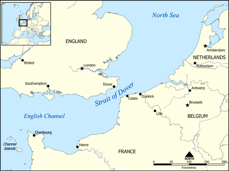
This map shows the location of the Strait of Dover between England and France, and part of the English Channel and the North Sea. It also shows nearby towns such as Dover, Calais, and Dunkirk. Created by NormanEinstein, December 15, 2005. |
| Tarehe | 15 Desemba 2005 (original upload date) |
| Chanzo | No machine-readable source provided. Own work assumed (based on copyright claims). |
| Mwandishi | No machine-readable author provided. NormanEinstein assumed (based on copyright claims). |
Hatimiliki
I, the copyright holder of this work, hereby publish it under the following licenses:

|
Ruhusa inakubalika kunakili, kusambaza na/au kurekebisha chini ya matakwa ya GNU Free Documentation License, Toleo 1.2 au toleo lolote lile la baadaye ambalo litachapishwa na Free Software Foundation; lisilo na Sehemu Tofauti, lisilo na Maandishi-Kava-Kwa-Mbele, na lisilo na Maandishi-Kava-Kwa -Nyuma. Nakala ya hatimiliki inajumlishwa kwenye sehemu ilioitwa GNU Free Documentation License. |
| Faili hii imeidhinishwa chini ya Creative Commons Attribution- Attribution-Share Alike 3.0 Unported leseni. | ||
shiriki sawa – Ukichanganya, kubadilisha, au kujenga juu ya nyenzo, lazima usambaze michango yako chini ya same or compatible license kama ya awali. | ||
| This licensing tag was added to this file as part of the GFDL licensing update. |
Unaweza kuchagua leseni ya chaguo lako.
Derivative works
-
 hrvatski (SVG)
 -
 македонски (SVG)
 -
 English (PNG), showing evacuation routes of the Dunkirk evacuation


| Annotations | This image is annotated: View the annotations at Commons |
Historia ya faili
Bonyeza tarehe/saa kuona faili kama ilivyoonekana wakati huo.
| Tarehe/Saa | Picha ndogo | Vipimo | Mtumiaji | Maelezo | |
|---|---|---|---|---|---|
| sasa hivi | 19:17, 13 Juni 2014 | | 1,000 × 751 (187 KB) | Hohum | Adjust colours |
| 15:34, 15 Desemba 2005 |  | 1,000 × 751 (296 KB) | NormanEinstein | This map shows the location of the Strait of Dover between England and France, and part of the English Channel and the North Sea. It also shows nearby towns such as Dover, Calais, and Dunkirk. Created by NormanEinstein, December 15, 2005. {{GFDL-self}} |
Matumizi ya faili
Ukurasa huu umeunganishwa na faili hili:
Matumizi ya faili ulimwenguni
Wiki nyingine hutumia faili hizi:
- Matumizi kwa af.wikipedia.org
- Matumizi kwa an.wikipedia.org
- Matumizi kwa ar.wikipedia.org
- Matumizi kwa ba.wikipedia.org
- Matumizi kwa be-tarask.wikipedia.org
- Matumizi kwa be.wikipedia.org
- Matumizi kwa bg.wikipedia.org
- Matumizi kwa bh.wikipedia.org
- Matumizi kwa bn.wikipedia.org
- Matumizi kwa br.wikipedia.org
- Matumizi kwa da.wikipedia.org
- Matumizi kwa de.wikipedia.org
- Matumizi kwa el.wikipedia.org
- Matumizi kwa en.wikipedia.org
- Matumizi kwa en.wikibooks.org
- Matumizi kwa fa.wikipedia.org
- Matumizi kwa fi.wikipedia.org
- Matumizi kwa fr.wikipedia.org
- Matumizi kwa fy.wikipedia.org
- Matumizi kwa gl.wikipedia.org
- Matumizi kwa hu.wikipedia.org
- Matumizi kwa id.wikipedia.org
- Matumizi kwa it.wikipedia.org
- Matumizi kwa ja.wikipedia.org
- Matumizi kwa la.wikipedia.org
- Matumizi kwa mr.wikipedia.org
- Matumizi kwa ms.wikipedia.org
- Matumizi kwa nn.wikipedia.org
- Matumizi kwa no.wikipedia.org
- Matumizi kwa pt.wikipedia.org
- Matumizi kwa ro.wikipedia.org
- Matumizi kwa simple.wikipedia.org
Tazama matumizi zaidi ya kimataifa ya faili hii.