
Faili:October 2012 - Overall Excellence in Smart Growth 2012- Lancaster, CA, The BLVD Transformation (8634270433).jpg

Faili halisi (piseli 5,616 × 3,744, saizi ya faili: 12.78 MB, aina ya MIME: image/jpeg)
| Faili hili linatoka Wikimedia Commons. Maelezo yapo kule kwenye ukurasa wake wa maelezo unaonekana hapo chini.
|
.jpg)
Muhtasari
| Maelezo |
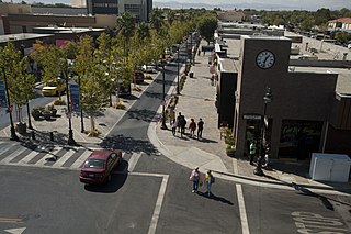
The redesign of Lancaster Boulevard helped transform downtown Lancaster into a thriving residential and commercial district through investments in new streetscape design, public facilities, affordable homes, and local businesses. Dubbed “The BLVD Transformation,” this comprehensive effort engaged residents and businesses to revitalize the formerly dilapidated downtown and make it a distinctive destination. Completed after just eight months of construction, The BLVD demonstrates how redesigning a corridor guided by a strategic vision can spark new life in a community. Photo courtesy of EPA. www.epa.gov/smartgrowth/awards/sg_awards_publication_2012... |
| Tarehe | |
| Chanzo | October 2012 - Overall Excellence in Smart Growth 2012: Lancaster, CA, The BLVD Transformation |
| Mwandishi | USEPA Environmental-Protection-Agency |
| Camera location | | View this and other nearby images on: OpenStreetMap |
|---|
.jpg¶ms=034.697907_N_-118.142037_E_globe:Earth_type:camera_source:Flickr_&language=sw)
Hatimiliki
This image (or other media) is a work of an Environmental Protection Agency employee, taken or made as part of that person's official duties. As works of the U.S. federal government, all EPA images are in the public domain.
|
||
| This image was originally posted to Flickr by usepagov at https://flickr.com/photos/24400159@N05/8634270433. It was reviewed on 1 Oktoba 2016 by FlickreviewR and was confirmed to be licensed under the terms of the United States Government Work. |
Historia ya faili
Bonyeza tarehe/saa kuona faili kama ilivyoonekana wakati huo.
| Tarehe/Saa | Picha ndogo | Vipimo | Mtumiaji | Maelezo | |
|---|---|---|---|---|---|
| sasa hivi | 05:50, 1 Oktoba 2016 | | 5,616 × 3,744 (12.78 MB) | Vanished Account Byeznhpyxeuztibuo | Transferred from Flickr via Flickr2Commons |
Matumizi ya faili
Ukurasa huu umeunganishwa na faili hili:
Matumizi ya faili ulimwenguni
Wiki nyingine hutumia faili hizi:
- Matumizi kwa ar.wikipedia.org
- Matumizi kwa arz.wikipedia.org
- Matumizi kwa azb.wikipedia.org
- Matumizi kwa be.wikipedia.org
- Matumizi kwa bg.wikipedia.org
- Matumizi kwa ca.wikipedia.org
- Matumizi kwa ce.wikipedia.org
- Matumizi kwa dag.wikipedia.org
- Matumizi kwa de.wikipedia.org
- Matumizi kwa en.wikipedia.org
- Matumizi kwa en.wikivoyage.org
- Matumizi kwa eo.wikipedia.org
- Matumizi kwa es.wikipedia.org
- Matumizi kwa eu.wikipedia.org
- Matumizi kwa fr.wikipedia.org
- Matumizi kwa ga.wikipedia.org
- Matumizi kwa he.wikivoyage.org
- Matumizi kwa ht.wikipedia.org
- Matumizi kwa hu.wikipedia.org
- Matumizi kwa it.wikipedia.org
- Matumizi kwa it.wikivoyage.org
- Matumizi kwa ko.wikipedia.org
- Matumizi kwa lld.wikipedia.org
- Matumizi kwa nl.wikipedia.org
- Matumizi kwa no.wikipedia.org
- Matumizi kwa pt.wikipedia.org
- Matumizi kwa ro.wikipedia.org
- Matumizi kwa ru.wikipedia.org
- Matumizi kwa sr.wikipedia.org
- Matumizi kwa szl.wikipedia.org
- Matumizi kwa tt.wikipedia.org
- Matumizi kwa uk.wikipedia.org
- Matumizi kwa uz.wikipedia.org
- Matumizi kwa vo.wikipedia.org
- Matumizi kwa www.wikidata.org
- Matumizi kwa zh.wikipedia.org
.jpg)