
Faili:IllyrianTribes.jpg
Ukubwa wa hakikisho: piseli 600 × 600. Ukubwa zingine: piseli 240 × 240 | piseli 480 × 480 | piseli 768 × 768 | piseli 1,024 × 1,024 | piseli 2,000 × 2,000.
Faili halisi (piseli 2,000 × 2,000, saizi ya faili: 2.24 MB, aina ya MIME: image/jpeg)
| Faili hili linatoka Wikimedia Commons. Maelezo yapo kule kwenye ukurasa wake wa maelezo unaonekana hapo chini.
|
Muhtasari
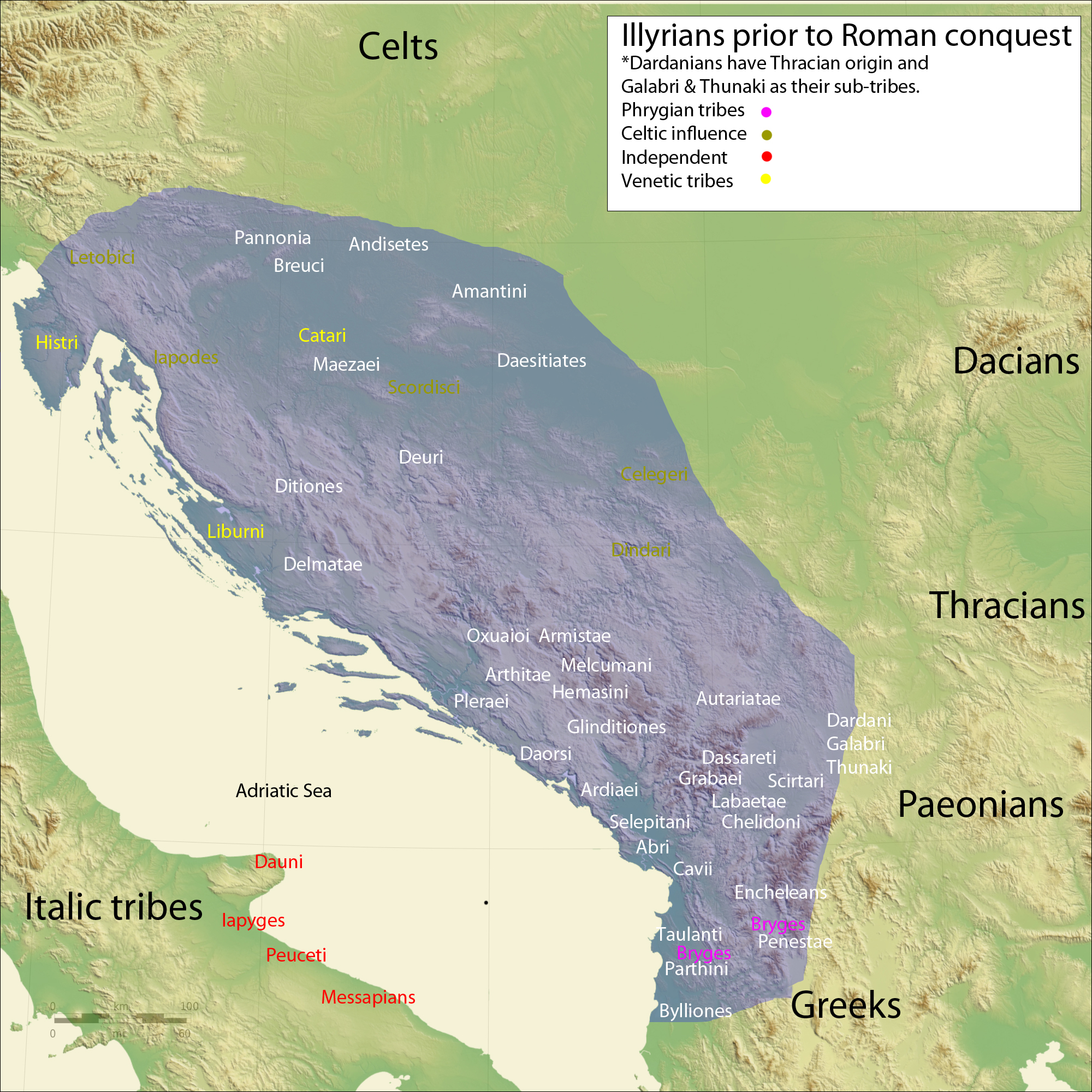
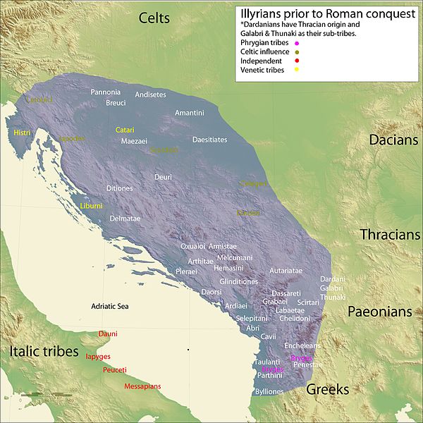
| Maelezo | Map of the Illyrian tribes | ||||||||||||
| Tarehe | |||||||||||||
| Chanzo |
Own work data from
|
||||||||||||
| Mwandishi | User:Megistias | ||||||||||||
| Ruhusa (Kutumia faili tena) |
I, the copyright holder of this work, hereby publish it under the following licenses:
This file is licensed under the Creative Commons Attribution-Share Alike 2.5 Generic license.
Unaweza kuchagua leseni ya chaguo lako. |
||||||||||||
| Matoleo mengine |
[]
|
.svg)

.png)

.svg)
.svg)
.svg)
.svg)
.svg)
.svg)
.svg)
.svg)
.svg)
.svg)
.svg)
.svg)
.svg)
.svg)
.svg)
.svg)
.svg)
.svg)
.svg)
.svg)
.svg)
.svg)
.svg)
.svg)
.svg)
.svg)
.svg)
.svg)
.svg)
.svg)
Hatimiliki
I, the copyright holder of this work, hereby publish it under the following licenses:

|
Ruhusa inakubalika kunakili, kusambaza na/au kurekebisha chini ya matakwa ya GNU Free Documentation License, Toleo 1.2 au toleo lolote lile la baadaye ambalo litachapishwa na Free Software Foundation; lisilo na Sehemu Tofauti, lisilo na Maandishi-Kava-Kwa-Mbele, na lisilo na Maandishi-Kava-Kwa -Nyuma. Nakala ya hatimiliki inajumlishwa kwenye sehemu ilioitwa GNU Free Documentation License. |
| Faili hii imeidhinishwa chini ya Creative Commons Attribution- Attribution-Share Alike 3.0 Unported leseni. | ||
shiriki sawa – Ukichanganya, kubadilisha, au kujenga juu ya nyenzo, lazima usambaze michango yako chini ya same or compatible license kama ya awali. | ||
| This licensing tag was added to this file as part of the GFDL licensing update. |
Unaweza kuchagua leseni ya chaguo lako.
Historia ya faili
Bonyeza tarehe/saa kuona faili kama ilivyoonekana wakati huo.
| Tarehe/Saa | Picha ndogo | Vipimo | Mtumiaji | Maelezo | |
|---|---|---|---|---|---|
| sasa hivi | 18:08, 19 Julai 2016 | | 2,000 × 2,000 (2.24 MB) | MaryroseB54 | The Illyrian Atintani, the Epirotic Atintanes and the Roman Protectorate N. G. L. Hammond, The Journal of Roman Studies Vol. 79 (1989), pp. 11-25 "There were Illyrian Amantini in Pannonia and Greek Amantes in North Epirus" |
| 13:38, 11 Februari 2010 |  | 2,000 × 2,000 (2.23 MB) | Megistias | lopsi | |
| 21:42, 22 Januari 2010 |  | 2,000 × 2,000 (2.24 MB) | Megistias | tweak | |
| 10:08, 22 Januari 2010 |  | 2,000 × 2,000 (2.23 MB) | Megistias | == {{int:filedesc}} == {{Information |Description=Map of the Illyrian tribes |Source=Own work data from *The central Balkan tribes in pre-Roman times: Triballi, Autariatae, Dardanians, Scordisci and Moesians by Fanula Papazoglu,1978,ISBN-9025607934 *The |
Matumizi ya faili
Hakuna kurasa zozote zinazotumia faili hii.
Matumizi ya faili ulimwenguni
Wiki nyingine hutumia faili hizi:
- Matumizi kwa en.wikipedia.org
- Matumizi kwa es.wikipedia.org