
Faili:Europe countries map 2.png

Ukubwa wa hakikisho: piseli 737 × 599. Ukubwa zingine: piseli 295 × 240 | piseli 590 × 480 | piseli 944 × 768 | piseli 1,259 × 1,024 | piseli 1,473 × 1,198.
Faili halisi (piseli 1,473 × 1,198, saizi ya faili: 745 KB, aina ya MIME: image/png)
| Faili hili linatoka Wikimedia Commons. Maelezo yapo kule kwenye ukurasa wake wa maelezo unaonekana hapo chini.
|
Muhtasari
| Maelezo |
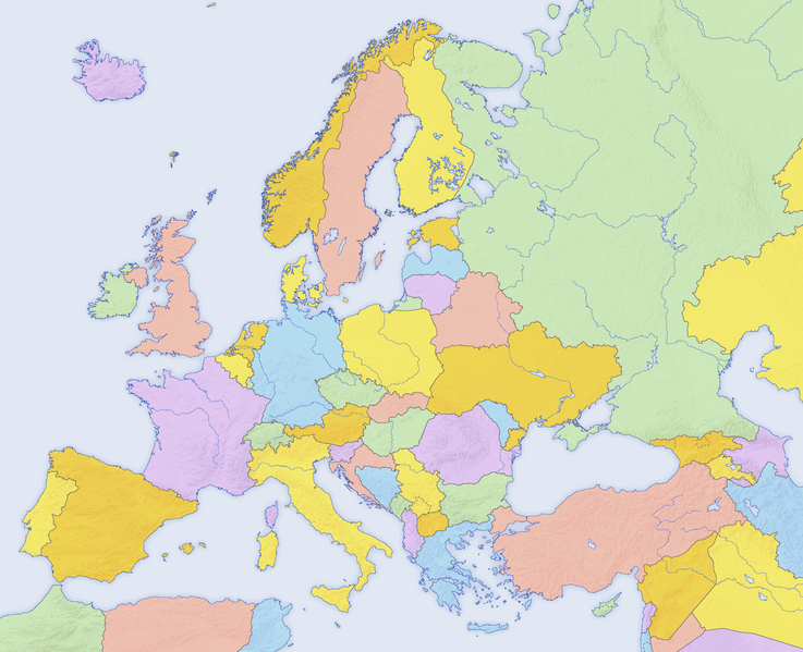
English: Map of countries in Europe and the surrounding region |
||||||||||
| Tarehe | |||||||||||
| Chanzo | derivative work of Europe countries map.png by San Jose, based on the Generic Mapping Tools and ETOPO2 | ||||||||||
| Mwandishi | San Jose (map), Hayden120 (retouch) | ||||||||||
| Ruhusa (Kutumia faili tena) |
|
||||||||||
| Matoleo mengine |
[]
|


| This is a retouched picture, which means that it has been digitally altered from its original version. Modifications: Saturation, brightness, contrast. The original can be viewed here: Europe countries map.png:
|
See also
_en.png)
.png)
.jpg)
Historia ya faili
Bonyeza tarehe/saa kuona faili kama ilivyoonekana wakati huo.
| Tarehe/Saa | Picha ndogo | Vipimo | Mtumiaji | Maelezo | |
|---|---|---|---|---|---|
| sasa hivi | 11:53, 28 Oktoba 2023 | | 1,473 × 1,198 (745 KB) | RockMFR | revert - this is intended to be the version without names |
| 17:08, 6 Agosti 2019 |  | 1,475 × 1,200 (1.21 MB) | Kontrollstellekundl | "Nord"mazedonien | |
| 23:49, 30 Machi 2017 |  | 1,473 × 1,198 (745 KB) | ZivDero | Reverted to version as of 18:33, 28 February 2016 (UTC) | |
| 18:23, 22 Machi 2016 |  | 1,473 × 1,198 (453 KB) | Artemis Dread | Reverted to version as of 13:50, 25 August 2012 (UTC) | |
| 18:33, 28 Februari 2016 |  | 1,473 × 1,198 (745 KB) | Мечников | изменение статуса территорий | |
| 13:50, 25 Agosti 2012 |  | 1,473 × 1,198 (453 KB) | Ras67 | cropped, opt. | |
| 07:47, 11 Septemba 2009 |  | 1,475 × 1,200 (791 KB) | Hayden120 | == {{int:filedesc}} == {{Information |Description= {{en|Map of countries in Europe}} |Source=derivative work of Europe countries map by San Jose, based on the [http://gmt.soest.hawaii.edu/ Generic Mapping T |
Matumizi ya faili
Ukurasa huu umeunganishwa na faili hili:
Matumizi ya faili ulimwenguni
Wiki nyingine hutumia faili hizi:
- Matumizi kwa af.wikipedia.org
- Matumizi kwa av.wikipedia.org
- Matumizi kwa ba.wikipedia.org
- Matumizi kwa be-tarask.wikipedia.org
- Matumizi kwa be.wikipedia.org
- Matumizi kwa bh.wikipedia.org
- Matumizi kwa bjn.wikipedia.org
- Matumizi kwa br.wikipedia.org
- Matumizi kwa ce.wikipedia.org
- Matumizi kwa gv.wikipedia.org
- Matumizi kwa hak.wikipedia.org
- Matumizi kwa hy.wikipedia.org
- Matumizi kwa incubator.wikimedia.org
- Matumizi kwa inh.wikipedia.org
- Matumizi kwa ka.wikipedia.org
- Matumizi kwa mt.wikipedia.org
- Matumizi kwa my.wikipedia.org
- Matumizi kwa pih.wikipedia.org
- Matumizi kwa pt.wikipedia.org
- Matumizi kwa sh.wikipedia.org
- Matumizi kwa si.wikipedia.org
- Matumizi kwa sr.wikipedia.org
- Matumizi kwa tt.wikipedia.org
- Matumizi kwa uk.wikipedia.org
- Обговорення:Молдова
- Обговорення:Токелау
- Шаблон:Countries and capitals-week-improve
- Обговорення:Оттава
- Шаблон:Countries and capitals-week-new
- Обговорення:Емблема Токелау
- Обговорення:Філіпсбург (Сінт-Мартен)
- Обговорення:Герб Скоп'я
- Обговорення:Кишинів
- Обговорення:Кінгстон (острів Норфолк)
- Обговорення:Герб Стокгольма
- Обговорення:Хагатна
- Обговорення:Держави та регіони Сомалі
- Обговорення:Історія Есватіні
- Обговорення:Бразильська Антарктика
- Обговорення:Територія Росса
- Обговорення:Герб Соломонових Островів
- Обговорення:Прапор Токелау
- Обговорення:Аргентинська Антарктида
- Обговорення:Галькайо
- Обговорення:Прапор Скоп'я
- Обговорення:Державна печатка Федеративних Штатів Мікронезії
- Обговорення:Державна печатка Маршаллових Островів
- Обговорення:Прапор Тирани
- Обговорення:Герб Тирани
Tazama matumizi zaidi ya kimataifa ya faili hii.