
Faili:Europe 814.png

Ukubwa wa hakikisho: piseli 777 × 600. Ukubwa zingine: piseli 311 × 240 | piseli 622 × 480 | piseli 995 × 768 | piseli 1,280 × 988 | piseli 1,393 × 1,075.
Faili halisi (piseli 1,393 × 1,075, saizi ya faili: 169 KB, aina ya MIME: image/png)
| Faili hili linatoka Wikimedia Commons. Maelezo yapo kule kwenye ukurasa wake wa maelezo unaonekana hapo chini.
|

Muhtasari
| Maelezo |
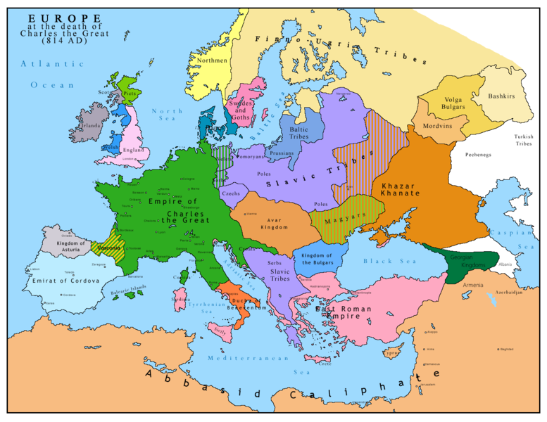
English: Map of Europe after the death of Charles the Great (814 AD). Original map made by Charles Colbeck, The Public Schools Historical Atlas (1905). |
|||
| Tarehe | 2009-04-15. Source date: 1905 by Longmans, Green; New York, London, Bombay 1905. | |||
| Chanzo | Own work based on: Europe 814.jpg | |||
| Mwandishi | Bukkia (majadiliano · michango) | |||
| Matoleo mengine |
|


Hatimiliki
| I, the copyright holder of this work, release this work into the public domain. This applies worldwide. Katika nchi zingine hii haiwezekani kisheria; kama ni hivyo: I grant anyone the right to use this work for any purpose, without any conditions, unless such conditions are required by law. |
_en.png)
.png)
.jpg)
Historia ya faili
Bonyeza tarehe/saa kuona faili kama ilivyoonekana wakati huo.
| Tarehe/Saa | Picha ndogo | Vipimo | Mtumiaji | Maelezo | |
|---|---|---|---|---|---|
| sasa hivi | 11:09, 26 Aprili 2023 | | 1,393 × 1,075 (169 KB) | OrionNimrod | Reverted to version as of 13:52, 23 December 2015 (UTC) restore |
| 16:09, 2 Mei 2019 |  | 1,370 × 1,047 (124 KB) | Julieta39 | Slavs also in the Avars and Bulgars kingdoms | |
| 13:52, 23 Desemba 2015 |  | 1,393 × 1,075 (169 KB) | Ercwlff | at that time armenia was already part of Arab caliphate.. and there were several Georgian kingdoms or principalities in the north of them | |
| 13:52, 8 Juni 2015 |  | 1,393 × 1,075 (157 KB) | Zorion | Vasconia in rebellion | |
| 17:49, 28 Mei 2015 |  | 1,393 × 1,075 (156 KB) | Zorion | From 812 to 824, Vasconia was ruled by Vascons (sourced can be found anywhere in spanish, basque or french). This map was wrong for that specific year. Seems that historian wanted to credit a famous king but, he was dead when Wasconia got back under th... | |
| 15:58, 24 Agosti 2014 |  | 1,393 × 1,075 (230 KB) | Martin H. | Reverted to version as of 14:53, 31 January 2010: File is consistent with its source file File:Europe 814.jpg; change conflicts with en:Duchy_of_Vasconia#Carolingian duchy (769–864) | |
| 14:42, 24 Agosti 2014 |  | 1,393 × 1,075 (156 KB) | Zorion | Vasconia was independant from frankish kingdom until 824 | |
| 14:53, 31 Januari 2010 |  | 1,393 × 1,075 (230 KB) | Bukkia | == {{int:filedesc}} == {{Information |Description={{it|1=Mappa dell'Europa alla morte di Carlo Magno (814 d.C.)}} {{en|1=Map of Europe after the death of Charles the Great (814 AD, in Italian)}} |Source=Based on File:Europe 814.jpg |Author=[[user:Buk |
Matumizi ya faili
Ukurasa huu umeunganishwa na faili hili:
Matumizi ya faili ulimwenguni
Wiki nyingine hutumia faili hizi:
- Matumizi kwa arz.wikipedia.org
- Matumizi kwa bo.wikipedia.org
- Matumizi kwa da.wikipedia.org
- Matumizi kwa de.wikipedia.org
- Matumizi kwa el.wikipedia.org
- Matumizi kwa en.wikipedia.org
- Matumizi kwa es.wikipedia.org
- Matumizi kwa fa.wikipedia.org
- Matumizi kwa fr.wikipedia.org
- Matumizi kwa gl.wikipedia.org
- Matumizi kwa he.wikipedia.org
- Matumizi kwa hu.wikipedia.org
- Matumizi kwa hy.wikipedia.org
- Matumizi kwa id.wikipedia.org
- Matumizi kwa it.wikipedia.org
- Matumizi kwa ko.wikipedia.org
- Matumizi kwa lmo.wikipedia.org
- Matumizi kwa lv.wikipedia.org
- Matumizi kwa mk.wikipedia.org
- Matumizi kwa pl.wikipedia.org
- Matumizi kwa ro.wikipedia.org
- Matumizi kwa sh.wikipedia.org
- Matumizi kwa sr.wikipedia.org
- Matumizi kwa uk.wikipedia.org