
Faili:ElectoralCollege1984.svg

Size of this PNG preview of this SVG file: piseli 800 × 465. Ukubwa zingine: piseli 320 × 186 | piseli 640 × 372 | piseli 1,024 × 595 | piseli 1,280 × 744 | piseli 2,560 × 1,488 | piseli 1,020 × 593.
Faili halisi (faili la SVG, husemwa kuwa piseli 1,020 × 593, saizi ya faili: 28 KB)
| Faili hili linatoka Wikimedia Commons. Maelezo yapo kule kwenye ukurasa wake wa maelezo unaonekana hapo chini.
|
Muhtasari
| Maelezo |
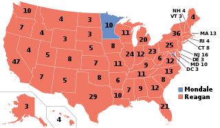
English: Electoral College results map for the 1984 United States presidential election between Ronald Reagan and Walter Mondale based on: https://www.archives.gov/electoral-college/1984 |
| Tarehe | |
| Chanzo | Kazi yangu |
| Mwandishi | SteveSims~commonswiki |
| U.S. presidential election maps (SVG) |
| See also: National Atlas maps (png) |
|
1789 · 1792 · 1796 · 1800 · 1804 · 1808 · 1812 · 1816 · 1820 · 1824 · 1828 · 1832 · 1836 · 1840 · 1844 · 1848 · 1852 · 1856 · 1860 · 1864 · 1868 · 1872 · 1876 · 1880 · 1884 · 1888 · 1892 · 1896 · 1900 · 1904 · 1908 · 1912 · 1916 · 1920 · 1924 · 1928 · 1932 · 1936 · 1940 · 1944 · 1948 · 1952 · 1956 · 1960 · 1964 · 1968 · 1972 · 1976 · 1980 · 1984 · 1988 · 1992 · 1996 · 2000 · 2004 · 2008 · 2012 · 2016 · 2020 · 2024 |
Hatimiliki
| I, the copyright holder of this work, release this work into the public domain. This applies worldwide. Katika nchi zingine hii haiwezekani kisheria; kama ni hivyo: I grant anyone the right to use this work for any purpose, without any conditions, unless such conditions are required by law. |
Historia ya faili
Bonyeza tarehe/saa kuona faili kama ilivyoonekana wakati huo.
| Tarehe/Saa | Picha ndogo | Vipimo | Mtumiaji | Maelezo | |
|---|---|---|---|---|---|
| sasa hivi | 12:50, 28 Desemba 2018 | | 1,020 × 593 (28 KB) | Newfraferz87 | Optimize |
| 11:26, 6 Februari 2017 |  | 1,020 × 593 (34 KB) | Newfraferz87 | Clearer state borders | |
| 16:50, 10 Desemba 2016 |  | 1,020 × 593 (35 KB) | WikiBunny2K1 | Updated map shape | |
| 22:30, 14 Julai 2008 |  | 1,020 × 593 (119 KB) | Noname224 | Fixed WV number | |
| 22:51, 14 Juni 2008 |  | 1,020 × 593 (119 KB) | SteveSims~commonswiki | fixed error | |
| 22:49, 14 Juni 2008 |  | 1,020 × 593 (119 KB) | SteveSims~commonswiki | == Summary == I created this image based on this map from the WikiMedia Commons: http://commons.wikimedia.org/wiki/Image:Blank_US_Map.svg It is in the public domain. == Licensing == {{PD-self}} |
Matumizi ya faili
Ukurasa huu umeunganishwa na faili hili:
Matumizi ya faili ulimwenguni
Wiki nyingine hutumia faili hizi:
- Matumizi kwa arz.wikipedia.org
- Matumizi kwa bg.wikipedia.org
- Matumizi kwa ca.wikipedia.org
- Matumizi kwa cs.wikipedia.org
- Matumizi kwa da.wikipedia.org
- Matumizi kwa de.wikipedia.org
- Matumizi kwa el.wikipedia.org
- Matumizi kwa eml.wikipedia.org
- Matumizi kwa en.wikipedia.org
- Ronald Reagan
- 1984
- 1984 United States presidential election
- Presidency of Ronald Reagan
- Electoral vote changes between United States presidential elections
- Wikipedia:Reference desk/Archives/Humanities/2007 May 4
- List of United States presidential election results by state
- 1984 United States presidential election in Missouri
- Electoral history of George H. W. Bush
- Electoral history of Ronald Reagan
- Fifty-state strategy
- 1984 United States presidential election in California
- 1984 United States presidential election in Minnesota
- United States presidential election
- 1984 in the United States
- 1984 United States presidential election in Florida
- 1984 United States presidential election in North Carolina
- 1984 United States presidential election in Pennsylvania
- 1984 United States elections
- Template:State results of the 1984 U.S. presidential election
- 1984 United States presidential election in Montana
- 1984 United States presidential election in Maryland
- 1984 United States presidential election in New York
- Template:1984 United States presidential election imagemap
- 1984 United States presidential election in Vermont
- 1984 United States presidential election in New Mexico
- 1984 United States presidential election in Indiana
- 1984 United States presidential election in New Hampshire
- 1984 United States presidential election in Massachusetts
- 1984 United States presidential election in Alaska
- 1984 United States presidential election in New Jersey
- 1984 United States presidential election in Hawaii
- 1984 United States presidential election in Washington (state)
- 1984 United States presidential election in Oregon
- 1984 United States presidential election in Idaho
- 1984 United States presidential election in Nevada
- 1984 United States presidential election in Wyoming
- 1984 United States presidential election in Utah
- 1984 United States presidential election in Arizona
Tazama matumizi zaidi ya kimataifa ya faili hii.