
Faili:East-Hem 1300bc.jpg

Faili halisi (piseli 3,240 × 1,903, saizi ya faili: 1.42 MB, aina ya MIME: image/jpeg)
| Faili hili linatoka Wikimedia Commons. Maelezo yapo kule kwenye ukurasa wake wa maelezo unaonekana hapo chini.
|

|
This historical map image could be re-created using vector graphics as an SVG file. This has several advantages; see Commons:Media for cleanup for more information. If an SVG form of this image is available, please upload it and afterwards replace this template with
{{vector version available|new image name}}.
It is recommended to name the SVG file “East-Hem 1300bc.svg”—then the template Vector version available (or Vva) does not need the new image name parameter. |


Muhtasari
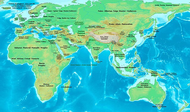
| Maelezo | Eastern Hemisphere in 1300 BC. |
| Chanzo | self-made (For reference information, see below) |
| Mwandishi | Thomas Lessman (Contact!) |
| Ruhusa (Kutumia faili tena) |
I, the copyright holder of this work, hereby publish it under the following license: Faili hii imeidhinishwa chini ya Creative Commons Attribution- Attribution-Share Alike 3.0 Unported leseni.
|
| Matoleo mengine | see East-Hem_1300bc.jpg file history on Wikipedia. |
Map Summary
Original Source URL: http://www.thomaslessman.com/History/images/East-Hem_050bc.jpg.
This map of the Eastern Hemisphere in 1300 BC was created by Thomas Lessman, based on information from the sources listed below. This map is free for educational use (see Permission info above). When using this map, please mention that it is available for free at www.WorldHistoryMaps.info.
Map Source References
- Remember, sources often conflict with each other. This map is only as accurate as the information that is available to me. To report any errors or to help further this work, please click here, or email Thomas Lessman at talessman@yis.us
References for information contained in this map:
1. The DK Atlas of World History, 2000 Edition; map of The World in 1250 BCE, (Pages 26-27) was used for much of the information in this map.
2. Borders of countries updated with info from various Wikipedia articles and Google history map searches.
| Maps of the eastern hemisphere showing history
Bold dates are available on Wikimedia or Wikipedia. | ||
| Primeval | ||
| Ancient
|
·| 600 BC | 550 BC | 527 BC | 500 BC |
400 BC | ·| 1 AD | 50 AD | 100 AD | 200 AD | 300 AD | | |
| Medieval |
·| 500 AD | 565 AD | 600 AD | 700 AD | | |
| Modern |
·| 1500 AD | · * For historical maps of the whole world, | |
Kumbukumbu ya upakizaji wa asili
- 2008-01-31 15:39 Talessman 3240×1903×8 (722196 bytes) Author: Thomas A. Lessman. Source URL: http://www.ThomasLessman.com/History/images/East-Hem_1300ad.jpg. Image was created by Thomas Lessman based on historical information located in sources listed below. This map is free for public and/or educational u
| Annotations | This image is annotated: View the annotations at Commons |


Historia ya faili
Bonyeza tarehe/saa kuona faili kama ilivyoonekana wakati huo.
| Tarehe/Saa | Picha ndogo | Vipimo | Mtumiaji | Maelezo | |
|---|---|---|---|---|---|
| sasa hivi | 11:28, 28 Septemba 2023 | | 3,240 × 1,903 (1.42 MB) | Notradeuussrs | added Punt |
| 19:31, 8 Februari 2010 |  | 3,240 × 1,903 (705 KB) | Roke~commonswiki | Reverted to version as of 13:22, 12 February 2008 wrong year | |
| 17:08, 4 Februari 2010 |  | 3,240 × 1,903 (2.19 MB) | Malus Catulus | Removed text | |
| 13:22, 12 Februari 2008 |  | 3,240 × 1,903 (705 KB) | Talessman | {{Information |Description={{en|Author: Thomas A. Lessman. Source URL: http://www.ThomasLessman.com/History/images/East-Hem_1300ad.jpg. |Source=Transferred from [http://en.wikipedia.org en.wikipedia]; Transfer was stated to be made by User:talessman. |
Matumizi ya faili
Ukurasa huu umeunganishwa na faili hili:
Matumizi ya faili ulimwenguni
Wiki nyingine hutumia faili hizi:
- Matumizi kwa af.wikipedia.org
- Matumizi kwa ar.wikipedia.org
- Matumizi kwa ast.wikipedia.org
- Matumizi kwa bs.wikipedia.org
- Matumizi kwa de.wikipedia.org
- Matumizi kwa el.wikipedia.org
- Matumizi kwa en.wikipedia.org
- 13th century BC
- Babylonia
- 1300s BC (decade)
- Outline of ancient India
- User:Tompw/sandbox10
- User:Talessman/Maps
- User talk:Talessman/Maps
- Nantucket series
- List of political entities in the 13th century BC
- User:Benjamin Trovato/sandbox
- Transjordan (region)
- User:Falcaorib
- User:SomeGuyWhoRandomlyEdits/List of conflicts in the Near East
- Matumizi kwa en.wikiversity.org
- Matumizi kwa fa.wikipedia.org
- Matumizi kwa gl.wikipedia.org
- Matumizi kwa he.wikipedia.org
- Matumizi kwa hy.wikipedia.org
- Matumizi kwa hyw.wikipedia.org
- Matumizi kwa lt.wikipedia.org
- Matumizi kwa ro.wikipedia.org
- Matumizi kwa sh.wikipedia.org
- Matumizi kwa simple.wikipedia.org
- Matumizi kwa si.wikipedia.org
- Matumizi kwa sv.wikipedia.org
- Matumizi kwa tr.wikipedia.org
- Matumizi kwa ur.wikipedia.org
- Matumizi kwa vi.wikipedia.org