
Faili:Demis-kurils-russian names.png
Hakuna saizi kubwa zaidi.
Demis-kurils-russian_names.png (piseli 663 × 462, saizi ya faili: 70 KB, aina ya MIME: image/png)
| Faili hili linatoka Wikimedia Commons. Maelezo yapo kule kwenye ukurasa wake wa maelezo unaonekana hapo chini.
|
Muhtasari
| Maelezo |
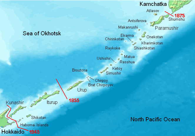
English: Kuril Islands overview map with current Russian names (English transliteration). Borders of Shimoda Treaty (1855) and Treaty of St. Petersburg (1875) shown in red. Currently all islands northeast of Hokkaido are administered by Russia. Note: Ushishir actually consists of 2 islands: Ryponkicha (northeast) and Yankicha (southwest).
Bahasa Indonesia: Peta yang menampilkan nama-nama pulau di Kepulauan Kuril dalam bahasa Rusia (transliterasi Inggris). Perbatasan dalam Traktat Shimoda (1855) dan Traktat Sankt-Peterburg (1875) ditunjukkan dalam warna merah. Sekarang semua pulau-pulau di timur laut Hokkaido dikuasai oleh Rusia. Catatan: Ushishir sebenarnya terdiri dari 2 pulau: Ryponkicha (timur laut) dan Yankicha (barat daya). |
| Tarehe | |
| Chanzo | Kazi yangu |
| Mwandishi | Hardscarf |
| Matoleo mengine |
|

Hatimiliki
This image is in the public domain because it came from the site https://www.demis.nl/products/web-map-server/examples/ and was released by the copyright holder. Permission is granted to copy, distribute and/or modify this map since it is based on free of copyright images from: www.demis.nl. See also approval email on de.wp and its clarification.
|
| This work has been released into the public domain by its copyright holder, www.demis.nl. This applies worldwide. Katika nchi zingine hii haiwezekani kisheria; kama ni hivyo: www.demis.nl grants anyone the right to use this work for any purpose, without any conditions, unless such conditions are required by law.
|
Historia ya faili
Bonyeza tarehe/saa kuona faili kama ilivyoonekana wakati huo.
| Tarehe/Saa | Picha ndogo | Vipimo | Mtumiaji | Maelezo | |
|---|---|---|---|---|---|
| sasa hivi | 18:27, 22 Mei 2008 | | 663 × 462 (70 KB) | ChrisDHDR | added the border since 1945 |
| 20:00, 23 Novemba 2006 |  | 663 × 462 (70 KB) | Hardscarf | Kuril Islands overviewmap with actual Russian names (English transliteration). Borders of Shimoda Treaty (1855) and Treaty of St. Petersburg (1875) shown in red. Currently all islands northwest of Hokkaido are administered by Russia. Note: Ushishir actua |
Matumizi ya faili
Ukurasa huu umeunganishwa na faili hili:
Matumizi ya faili ulimwenguni
Wiki nyingine hutumia faili hizi:
- Matumizi kwa ace.wikipedia.org
- Matumizi kwa af.wikipedia.org
- Matumizi kwa ar.wikipedia.org
- Matumizi kwa az.wikipedia.org
- Matumizi kwa be.wikipedia.org
- Matumizi kwa bg.wikipedia.org
- Matumizi kwa br.wikipedia.org
- Matumizi kwa ca.wikipedia.org
- Matumizi kwa ckb.wikipedia.org
- Matumizi kwa cs.wikipedia.org
- Matumizi kwa da.wikipedia.org
- Matumizi kwa de.wikipedia.org
- Kurilen
- Vierte Kurilenstraße
- Kurilenstraße
- Zweite Kurilenstraße
- Nemuro-Straße
- Fries-Straße
- Luschin-Straße
- Krusenstern-Straße
- Jekaterina-Straße
- Boussole-Straße
- Kurilenstraßen
- Nadeschda-Straße
- 27. Armee (Japanisches Kaiserreich)
- 91. Division (Japanisches Kaiserreich)
- 5. Regionalarmee
- Benutzer:Bluemel1/Juli 1990
- Vorlage:Navigationsleiste Kurilenstraßen
- Matumizi kwa en.wikipedia.org
- Matumizi kwa en.wiktionary.org
- Matumizi kwa es.wikipedia.org
Tazama matumizi zaidi ya kimataifa ya faili hii.