
Faili:Delagoa bay.jpg

Ukubwa wa hakikisho: piseli 600 × 599. Ukubwa zingine: piseli 240 × 240 | piseli 480 × 480 | piseli 769 × 768 | piseli 1,025 × 1,024 | piseli 2,050 × 2,048 | piseli 5,285 × 5,280.
Faili halisi (piseli 5,285 × 5,280, saizi ya faili: 7.15 MB, aina ya MIME: image/jpeg)
| Faili hili linatoka Wikimedia Commons. Maelezo yapo kule kwenye ukurasa wake wa maelezo unaonekana hapo chini.
|
Muhtasari
| Maelezo |
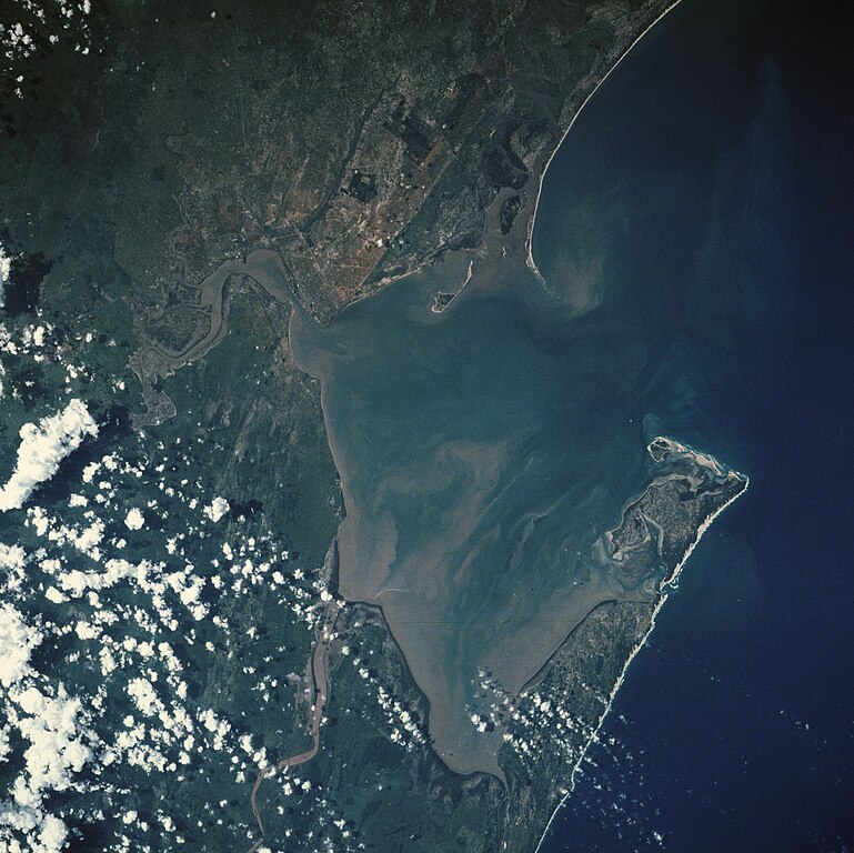
Afrikaans: Gesig op Maputo en Delagoabaai uit die ruimte. Machangulo-skiereiland en Inhaca-eiland is regs sigbaar. Drie riviere mond in die baai uit, die Komati uit die noorde, Groot Usutu uit die suide, en Mbuluzi aan die westekant, waarvan die troebel waters telkens opsigtelik is.
Gelaai vanaf en:wiki; hierdie NASA-beeld is sonder kopiereg. English: NASA picture of Maputo Bay (formerly Delagoa Bay) |
| Tarehe | |
| Chanzo | Earth from Space |
| Mwandishi | Image Science and Analysis Laboratory, NASA-Johnson Space Center |
| Matoleo mengine | Derivative works of this file: Delagoa Bay00.jpg |
| Object location | | View this and other nearby images on: OpenStreetMap |
|---|
This image or video was catalogued by one of the centers of the United States National Aeronautics and Space Administration (NASA) under Photo ID: STS032-74-24. This tag does not indicate the copyright status of the attached work. A normal copyright tag is still required. See Commons:Licensing. Other languages:
|
Hatimiliki
| This file is in the public domain in the United States because it was solely created by NASA. NASA copyright policy states that "NASA material is not protected by copyright unless noted". (See Template:PD-USGov, NASA copyright policy page or JPL Image Use Policy.) | ||
 |
Warnings:
|
Kumbukumbu ya upakizaji wa asili
The original description page was here. All following user names refer to af.wikipedia.
- 2006-02-08 03:08 Davinci77 639×639×8 (126389 bytes) Gelaai vanaf en:wiki; hierdie is 'n NASA beeld sonder kopiereg. {{PD-USGov-NASA}}
Historia ya faili
Bonyeza tarehe/saa kuona faili kama ilivyoonekana wakati huo.
| Tarehe/Saa | Picha ndogo | Vipimo | Mtumiaji | Maelezo | |
|---|---|---|---|---|---|
| sasa hivi | 20:01, 2 Septemba 2019 | | 5,285 × 5,280 (7.15 MB) | SteinsplitterBot | Bot: Image rotated by 270° |
| 18:34, 2 Septemba 2019 |  | 5,285 × 5,285 (7.18 MB) | Ariadacapo | Higher res from source | |
| 12:30, 15 Agosti 2019 |  | 639 × 624 (132 KB) | JMK | adjust various parameters | |
| 18:10, 23 Oktoba 2012 |  | 639 × 624 (121 KB) | OAlexander~commonswiki | Rotated so that it resembles North-South/East-West. | |
| 14:45, 28 Desemba 2007 |  | 639 × 639 (123 KB) | File Upload Bot (Magnus Manske) | {{BotMoveToCommons|af.wikipedia}} {{Information |Description={{af|Gelaai vanaf en:wiki; hierdie is 'n NASA beeld sonder kopiereg.}} |Source=Transfered from [http://af.wikipedia.org af.wikipedia] |Date=2006-02-08 (original upload date) |Author=Original up |
Matumizi ya faili
Hakuna kurasa zozote zinazotumia faili hii.
Matumizi ya faili ulimwenguni
Wiki nyingine hutumia faili hizi:
- Matumizi kwa af.wikipedia.org
- Matumizi kwa ar.wikipedia.org
- Matumizi kwa ast.wikipedia.org
- Matumizi kwa bg.wikipedia.org
- Matumizi kwa bn.wikipedia.org
- Matumizi kwa ca.wikipedia.org
- Matumizi kwa ceb.wikipedia.org
- Matumizi kwa de.wikipedia.org
- Matumizi kwa en.wikipedia.org
- Matumizi kwa eo.wikipedia.org
- Matumizi kwa es.wikipedia.org
- Matumizi kwa fa.wikipedia.org
- Matumizi kwa fr.wikipedia.org
- Matumizi kwa hr.wikipedia.org
- Matumizi kwa id.wikipedia.org
- Matumizi kwa it.wikipedia.org
- Matumizi kwa ja.wikipedia.org
- Matumizi kwa ka.wikipedia.org
- Matumizi kwa ko.wikipedia.org
- Matumizi kwa lt.wikipedia.org
- Matumizi kwa nl.wikipedia.org
- Matumizi kwa no.wikipedia.org
- Matumizi kwa pl.wikipedia.org
- Matumizi kwa pt.wikipedia.org
- Matumizi kwa sr.wikipedia.org
- Matumizi kwa sv.wikipedia.org
- Matumizi kwa uk.wikipedia.org
- Matumizi kwa vi.wikipedia.org
- Matumizi kwa www.wikidata.org
- Matumizi kwa zh-yue.wikipedia.org
- Matumizi kwa zh.wikipedia.org