
Faili:Western sahara walls moroccan.png

Ukubwa wa hakikisho: piseli 746 × 600. Ukubwa zingine: piseli 299 × 240 | piseli 597 × 480 | piseli 904 × 727.
Faili halisi (piseli 904 × 727, saizi ya faili: 26 KB, aina ya MIME: image/png)
| Faili hili linatoka Wikimedia Commons. Maelezo yapo kule kwenye ukurasa wake wa maelezo unaonekana hapo chini.
|
Muhtasari
| Maelezo |
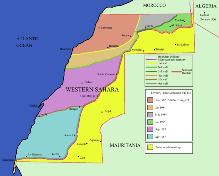
English: Map of the w:Moroccan Defensive Wall in w:Sahara - built over several stages during war against backed Algerian and Libya militias POLISARIO , shows the six Defensive walls built, & when the territory was behind Moroccan defensive wall. Also shows polisaro held territory who are based in Algeria (seen at top right). the map using UN old map map prior to ceasefire , polisario do not hold any territory within Moroccan borders , they are hosted in tindouf camps on Algerian territory [1] and this map [2]. |
|||
| Chanzo | Identical PNG copy of [3] | |||
| Mwandishi | User:Roke | |||
| Matoleo mengine |
See: Category:Maps of the Moroccan Wall
[]
|


![[2]](https://web.archive.org/web/20110208043824/https://www.marrakech-expedition-4x4.com/images/map.jpg)
Hatimiliki

|
Ruhusa inakubalika kunakili, kusambaza na/au kurekebisha chini ya matakwa ya GNU Free Documentation License, Toleo 1.2 au toleo lolote lile la baadaye ambalo litachapishwa na Free Software Foundation; lisilo na Sehemu Tofauti, lisilo na Maandishi-Kava-Kwa-Mbele, na lisilo na Maandishi-Kava-Kwa -Nyuma. Nakala ya hatimiliki inajumlishwa kwenye sehemu ilioitwa GNU Free Documentation License. |
| Faili hii imeidhinishwa chini ya Creative Commons Attribution- Attribution-Share Alike 3.0 Unported leseni. | ||
shiriki sawa – Ukichanganya, kubadilisha, au kujenga juu ya nyenzo, lazima usambaze michango yako chini ya same or compatible license kama ya awali. | ||
| This licensing tag was added to this file as part of the GFDL licensing update. |
Historia ya faili
Bonyeza tarehe/saa kuona faili kama ilivyoonekana wakati huo.
| Tarehe/Saa | Picha ndogo | Vipimo | Mtumiaji | Maelezo | |
|---|---|---|---|---|---|
| sasa hivi | 13:44, 10 Desemba 2009 | | 904 × 727 (26 KB) | Reisio | == {{int:filedesc}} == Map of the w:Moroccan Wall in w:Western Sahara - built over several stages, shows the six walls built, & when the territory was behind Moroccan wall. Also shows polisaro held territory who are based in Algeria (seen at top r |
Matumizi ya faili
Hakuna kurasa zozote zinazotumia faili hii.
Matumizi ya faili ulimwenguni
Wiki nyingine hutumia faili hizi:
- Matumizi kwa es.wikipedia.org