
Faili:Sunda Strait map-fr.svg

Size of this PNG preview of this SVG file: piseli 800 × 535. Ukubwa zingine: piseli 320 × 214 | piseli 640 × 428 | piseli 1,024 × 685 | piseli 1,280 × 857 | piseli 2,560 × 1,713 | piseli 3,579 × 2,395.
Faili halisi (faili la SVG, husemwa kuwa piseli 3,579 × 2,395, saizi ya faili: 2.08 MB)
| Faili hili linatoka Wikimedia Commons. Maelezo yapo kule kwenye ukurasa wake wa maelezo unaonekana hapo chini.
|
Muhtasari
| Maelezo |
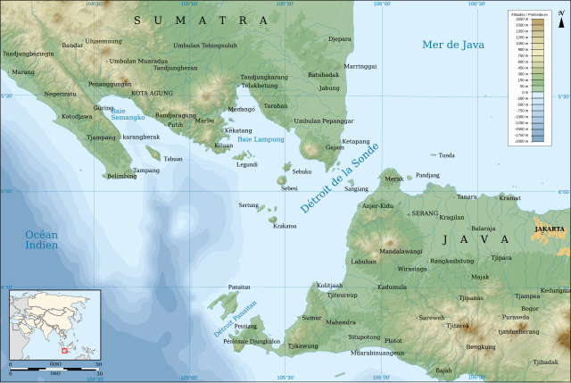
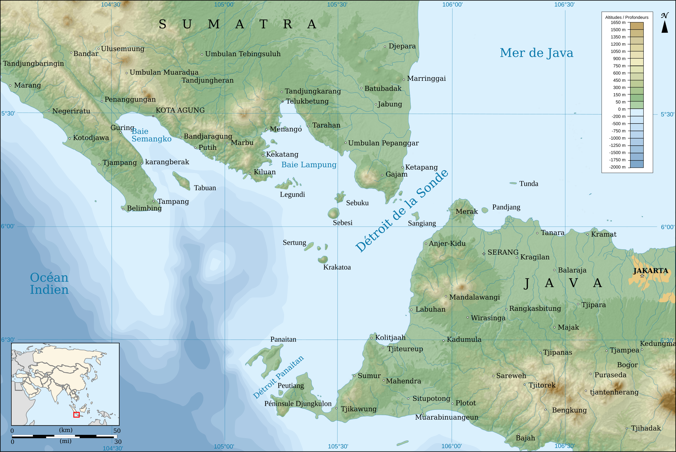
English: Map of the Sunda Strait, in french.
Français : Carte du Détroit de la Sonde, en français. |
||
| Tarehe | |||
| Chanzo |
travail personnel. Source :
|
||
| Mwandishi | Pinpin | ||
| Matoleo mengine | |||
| SVG | W3C-validity not checked.
|
||
| Graphic Lab |

| Camera location | | View this and other nearby images on: OpenStreetMap |
|---|
Hatimiliki
I, the copyright holder of this work, hereby publish it under the following licenses:
| Copyleft: This work of art is free; you can redistribute it and/or modify it according to terms of the Free Art License. You will find a specimen of this license on the Copyleft Attitude site as well as on other sites. |
This file is licensed under the Creative Commons Attribution-Share Alike 4.0 International, 3.0 Unported, 2.5 Generic, 2.0 Generic and 1.0 Generic license.
- Uko huru:
- kushiriki – kunakili na kusambaza kazi hiyo
- kwa remix – kurekebisha kazi
- Chini ya masharti yafuatayo:
- sifa – Ni lazima utoe mkopo unaofaa, utoe kiungo cha leseni, na uonyeshe ikiwa mabadiliko yalifanywa. Unaweza kufanya hivyo kwa njia yoyote inayofaa, lakini si kwa njia yoyote inayopendekeza mtoa leseni akuidhinishe wewe au matumizi yako.
Unaweza kuchagua leseni ya chaguo lako.
Historia ya faili
Bonyeza tarehe/saa kuona faili kama ilivyoonekana wakati huo.
| Tarehe/Saa | Picha ndogo | Vipimo | Mtumiaji | Maelezo | |
|---|---|---|---|---|---|
| sasa hivi | 12:40, 24 Desemba 2018 | | 3,579 × 2,395 (2.08 MB) | Sémhur | Scale correction. |
| 11:39, 24 Aprili 2008 |  | 3,579 × 2,395 (2.09 MB) | Sémhur | {{Information |Description= {{en|Map of the Sunda Strait, in french.}} {{fr|Carte du Détroit de la Sonde, en français.}} |Source=travail personnel. Source : * Fond de carte : [http://www2.jpl.nasa.gov/sr |
Matumizi ya faili
Ukurasa huu umeunganishwa na faili hili:
Matumizi ya faili ulimwenguni
Wiki nyingine hutumia faili hizi:
- Matumizi kwa ban.wikipedia.org
- Matumizi kwa bcl.wikipedia.org
- Matumizi kwa bn.wikipedia.org
- Matumizi kwa bs.wikinews.org
- Matumizi kwa ca.wikipedia.org
- Matumizi kwa cy.wikipedia.org
- Matumizi kwa en.wikipedia.org
- Matumizi kwa eo.wikipedia.org
- Matumizi kwa es.wikipedia.org
- Matumizi kwa eu.wikipedia.org
- Matumizi kwa fr.wikipedia.org
- Matumizi kwa gl.wikipedia.org
- Matumizi kwa he.wikipedia.org
- Matumizi kwa hi.wikipedia.org
- Matumizi kwa hr.wikipedia.org
- Matumizi kwa id.wikipedia.org
- Matumizi kwa ja.wikipedia.org
- Matumizi kwa ko.wikipedia.org
- Matumizi kwa la.wikipedia.org
- Matumizi kwa mk.wikipedia.org
- Matumizi kwa ml.wikipedia.org
- Matumizi kwa ms.wikipedia.org
- Matumizi kwa nl.wikipedia.org
- Matumizi kwa nn.wikipedia.org
- Matumizi kwa oc.wikipedia.org
- Matumizi kwa su.wikipedia.org
- Matumizi kwa vi.wikipedia.org
- Matumizi kwa www.wikidata.org
- Matumizi kwa zh-min-nan.wikipedia.org