
Faili:Spain and Portugal.png

Ukubwa wa hakikisho: piseli 800 × 411. Ukubwa zingine: piseli 320 × 164 | piseli 640 × 329 | piseli 1,024 × 526 | piseli 1,500 × 771.
Faili halisi (piseli 1,500 × 771, saizi ya faili: 92 KB, aina ya MIME: image/png)
| Faili hili linatoka Wikimedia Commons. Maelezo yapo kule kwenye ukurasa wake wa maelezo unaonekana hapo chini.
|
Muhtasari

|
This map image could be re-created using vector graphics as an SVG file. This has several advantages; see Commons:Media for cleanup for more information. If an SVG form of this image is available, please upload it and afterwards replace this template with
{{vector version available|new image name}}.
It is recommended to name the SVG file “Spain and Portugal.svg”—then the template Vector version available (or Vva) does not need the new image name parameter. |
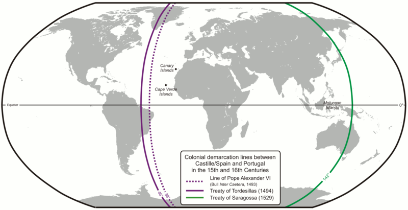
| Maelezo | Colonial demarcation lines between Castille/Spain and Portugal in the 15th and 16th Centuries. (Treaty of Tordesillas and Treaty of Saragossa) |
| Tarehe | |
| Chanzo | Kazi yangu |
| Mwandishi | Lencer |
| Matoleo mengine |
|


|
This map has been made or improved in the German Kartenwerkstatt (Map Lab). You can propose maps to improve as well.
|
Hatimiliki
The map has been created with the Generic Mapping Tools: https://www.generic-mapping-tools.org/ using one or more of these public-domain datasets for the relief:
|

|
Ruhusa inakubalika kunakili, kusambaza na/au kurekebisha chini ya matakwa ya GNU Free Documentation License, Toleo 1.2 au toleo lolote lile la baadaye ambalo litachapishwa na Free Software Foundation; lisilo na Sehemu Tofauti, lisilo na Maandishi-Kava-Kwa-Mbele, na lisilo na Maandishi-Kava-Kwa -Nyuma. Nakala ya hatimiliki inajumlishwa kwenye sehemu ilioitwa GNU Free Documentation License. |
| Faili hii imeidhinishwa chini ya Creative Commons Attribution- Attribution-Share Alike 3.0 Unported leseni. | ||
shiriki sawa – Ukichanganya, kubadilisha, au kujenga juu ya nyenzo, lazima usambaze michango yako chini ya same or compatible license kama ya awali. | ||
| This licensing tag was added to this file as part of the GFDL licensing update. |
Historia ya faili
Bonyeza tarehe/saa kuona faili kama ilivyoonekana wakati huo.
| Tarehe/Saa | Picha ndogo | Vipimo | Mtumiaji | Maelezo | |
|---|---|---|---|---|---|
| sasa hivi | 07:52, 16 Februari 2013 | | 1,500 × 771 (92 KB) | JohnnyMrNinja | indexed colors and increased compression |
| 09:10, 7 Desemba 2007 |  | 1,500 × 771 (254 KB) | Lencer | {{Convert to SVG|map}} {{Information |Description= Karte der spanischen und portugiesischen Einflussbereiche nach den Verträgen von Tordesillas, Saragossa und [[:de:Vertrag von Alcaçovas|Alca |
Matumizi ya faili
Ukurasa huu umeunganishwa na faili hili:
Matumizi ya faili ulimwenguni
Wiki nyingine hutumia faili hizi:
- Matumizi kwa ar.wikipedia.org
- Matumizi kwa ast.wikipedia.org
- Matumizi kwa ca.wikipedia.org
- Matumizi kwa cs.wikipedia.org
- Matumizi kwa el.wikipedia.org
- Matumizi kwa en.wikipedia.org
- 1529
- Treaty of Tordesillas
- Portuguese Empire
- Spanish Empire
- Age of Discovery
- Spanish Canadians
- Slavery in colonial Spanish America
- Portuguese maritime exploration
- Alexandre de Gusmão
- List of territorial claims and designations in Colorado
- Territorial evolution of California
- Treaty of Zaragoza
- User:Mcapdevila/LatMaps
- Matumizi kwa en.wikivoyage.org
- Matumizi kwa eo.wikipedia.org
- Matumizi kwa es.wikipedia.org
- Matumizi kwa et.wikipedia.org
- Matumizi kwa fa.wikipedia.org
- Matumizi kwa fi.wikipedia.org
- Matumizi kwa fr.wikipedia.org
- Matumizi kwa hy.wikipedia.org
- Matumizi kwa id.wikipedia.org
- Matumizi kwa it.wikipedia.org
Tazama matumizi zaidi ya kimataifa ya faili hii.