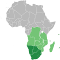
Faili:Southern African Development Community.svg

Yaliyomo ya ukurasa hayatumiki katika lugha nyingine.
Kutoka Wikipedia, kamusi elezo huru

Faili halisi(faili la SVG, husemwa kuwa piseli 1,000 × 1,000, saizi ya faili: 184 KB)

Faili hili linatoka Wikimedia Commons. Maelezo yapo kule kwenye ukurasa wake wa maelezo unaonekana hapo chini.
Commons ni mahali mtandaoni pa kuhifadhia jalada na hati za picha na sauti zenye leseni huria. Unaweza kuisadia.

Muhtasari

Maelezo Map of Africa showing the member nations of the Southern African Development Community (SADC). Nations that are members of SADC and the Southern African Customs Union (SACU) are coloured dark green, while those that are members of SADC only are coloured light green.
Tarehe (UTC)
Chanzo
Mwandishi

Hatimiliki

Public domain I, the copyright holder of this work, release this work into the public domain. This applies worldwide.
Katika nchi zingine hii haiwezekani kisheria; kama ni hivyo:
I grant anyone the right to use this work for any purpose, without any conditions, unless such conditions are required by law.

Kumbukumbu ya upakizaji wa asili

This image is a derivative work of the following images:

  • File:BlankMap-Africa.svg licensed with PD-user
    • 2011-11-08T13:50:11Z Htonl 1000x1000 (188219 Bytes) South Sudan has been allocated ISO code SS; change class and id correspondingly
    • 2011-07-09T21:38:33Z Lokal Profil 1000x1000 (188235 Bytes) Fixed code. Essentialy reverted and readded south sudan manually
    • 2011-07-09T17:09:06Z Seb az86556 1000x1000 (189357 Bytes) +South Sudan
    • 2010-07-18T16:04:42Z Stephen Morley 1000x1000 (189216 Bytes) Fixed errors that made SVG invalid
    • 2009-09-22T16:22:54Z Lokal Profil 1000x1000 (188987 Bytes) Reverted to version as of 00:54, 3 April 2008; the new map contains none of the iso code and css abilities of the original
    • 2009-09-22T15:11:08Z NuclearVacuum 1000x1000 (360040 Bytes) minor change
    • 2009-09-22T15:06:20Z NuclearVacuum 1000x1000 (360239 Bytes) Fixed map so it shows surrounding countries as well as making the code valid
    • 2008-04-03T00:54:00Z Lokal Profil 1000x1000 (188987 Bytes) reunion, saint helena, madeira and canary islands (mayotte already in) added for completion
    • 2008-04-01T00:21:58Z Lokal Profil 1000x1000 (185868 Bytes) Made circles smaller, and circular. They were the right size for the world map but to big for the Africa only map
    • 2008-03-31T23:55:20Z Lokal Profil 1000x1000 (185877 Bytes) Removed circle for gambia, not needed for Africa only map
    • 2008-03-24T03:09:01Z Lokal Profil 1000x1000 (186084 Bytes) {{Information |Description=Blank map of Africa Detailed SVG map with grouping enabled to connect all non-contiguous parts of a country's territory for easy colouring. Smaller countries can also be represented by larger circl

Uploaded with derivativeFX

Captions

Add a one-line explanation of what this file represents

Items portrayed in this file

depicts Kiingereza

20 Novemba 2011

Historia ya faili

Bonyeza tarehe/saa kuona faili kama ilivyoonekana wakati huo.

Tarehe/SaaPicha ndogoVipimoMtumiajiMaelezo
sasa hivi10:34, 23 Julai 2018Picha ndogo ya toleo la 10:34, 23 Julai 20181,000 × 1,000 (184 KB)YdecreuxAdded Comoros
11:59, 21 Novemba 2011Picha ndogo ya toleo la 11:59, 21 Novemba 20111,000 × 1,000 (184 KB)Htonlcolor scheme
13:20, 20 Novemba 2011Picha ndogo ya toleo la 13:20, 20 Novemba 20111,000 × 1,000 (184 KB)Htonl== {{int:filedesc}} == {{Information |Description=Map of Africa showing the member nations of the w:Southern African Development Community (SADC). Nations that are members of SADC and the w:Southern African Customs Union (SACU) are coloured dark

Ukurasa huu umeunganishwa na faili hili:

Matumizi ya faili ulimwenguni

Wiki nyingine hutumia faili hizi:

Data juu