
Faili:Samoyedic map XVII-XX.png
Hakuna saizi kubwa zaidi.
Samoyedic_map_XVII-XX.png (piseli 450 × 500, saizi ya faili: 36 KB, aina ya MIME: image/png)
| Faili hili linatoka Wikimedia Commons. Maelezo yapo kule kwenye ukurasa wake wa maelezo unaonekana hapo chini.
|
| Maelezo |
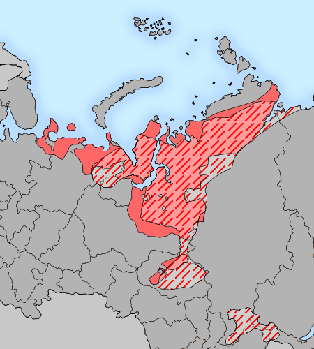
English: The map of distribution of Samoyedic languages (red) in the XVII century (approximate; hatching) and in the end of XX century (continuous background). Русский: Карта распространения самодийских языков (красный) в XVII веке (приблизительно; штриховка) и в конце XX века (сплошной фон). |
||
| Tarehe | |||
| Chanzo |
background: File:Map of Russian subjects recent.png;
|
||
| Mwandishi | Background map by user:fremantleboy, language map by Minami Himemiya | ||
| Ruhusa (Kutumia faili tena) |
This file is licensed under the Creative Commons Attribution 2.5 Generic license.
|
||
| Matoleo mengine |
|

Historia ya faili
Bonyeza tarehe/saa kuona faili kama ilivyoonekana wakati huo.
| Tarehe/Saa | Picha ndogo | Vipimo | Mtumiaji | Maelezo | |
|---|---|---|---|---|---|
| sasa hivi | 22:30, 19 Januari 2009 | | 450 × 500 (36 KB) | 姫宮南 | {{Information |Description={{en|The map of distribution of Samoyedic languages (red) in the XVII century (approximate; hatching) and in the end of XX century (continuous background).}}{{ru|Карта распространен� |
| 17:11, 3 Januari 2009 |  | 450 × 500 (36 KB) | 姫宮南 | {{Information |Description={{en|The map of distribution of en:Samoyedic languages (red) in the XVII century (approximate; hatching) and in the end of XX century (continuous background).}}{{ru|Карта распространения [[:ru:Само� |
Matumizi ya faili
Ukurasa huu umeunganishwa na faili hili:
Matumizi ya faili ulimwenguni
Wiki nyingine hutumia faili hizi:
- Matumizi kwa af.wikipedia.org
- Matumizi kwa als.wikipedia.org
- Matumizi kwa ar.wikipedia.org
- Matumizi kwa azb.wikipedia.org
- Matumizi kwa az.wikipedia.org
- Matumizi kwa ba.wikipedia.org
- Matumizi kwa be-tarask.wikipedia.org
- Matumizi kwa bg.wikipedia.org
- Matumizi kwa ca.wikipedia.org
- Matumizi kwa cs.wikipedia.org
- Matumizi kwa da.wikipedia.org
- Matumizi kwa de.wikipedia.org
- Matumizi kwa el.wikipedia.org
- Matumizi kwa en.wikipedia.org
- Matumizi kwa eo.wikipedia.org
- Matumizi kwa es.wikipedia.org
- Matumizi kwa et.wikipedia.org
- Matumizi kwa fa.wikipedia.org
- Matumizi kwa fi.wikipedia.org
- Matumizi kwa frr.wikipedia.org
- Matumizi kwa fr.wikipedia.org
- Matumizi kwa hi.wikipedia.org
- Matumizi kwa hr.wikipedia.org
- Matumizi kwa hu.wikipedia.org
- Matumizi kwa incubator.wikimedia.org
- Matumizi kwa it.wikipedia.org
- Matumizi kwa kk.wikipedia.org
- Matumizi kwa koi.wikipedia.org
- Matumizi kwa ko.wikipedia.org
- Matumizi kwa kv.wikipedia.org
- Matumizi kwa la.wikipedia.org
- Matumizi kwa lfn.wikipedia.org
- Matumizi kwa li.wikipedia.org
- Matumizi kwa lt.wikipedia.org
- Matumizi kwa nl.wikipedia.org
- Matumizi kwa nn.wikipedia.org
- Matumizi kwa pl.wikipedia.org
Tazama matumizi zaidi ya kimataifa ya faili hii.