
Faili:SafsafOasis SAR comparison.jpg
Hakuna saizi kubwa zaidi.
SafsafOasis_SAR_comparison.jpg (piseli 540 × 588, saizi ya faili: 154 KB, aina ya MIME: image/jpeg)
| Faili hili linatoka Wikimedia Commons. Maelezo yapo kule kwenye ukurasa wake wa maelezo unaonekana hapo chini.
|
Muhtasari
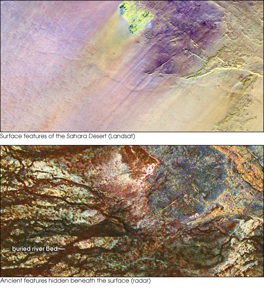
| Maelezo | Two images of the Safsaf Oasis in The Sahara. The top image (taken by the Landat Thematic Mapper) is the surface. The bottom (taken by the Spaceborne Imaging Radar-C/X-band Synthetic Aperture Radar (SIR-C/X-SAR) on board the Space Shuttle Endeavour on April 16, 1994) is the rock layer underneath, revealing black channels cut by the meandering of an ancient river. |
| Tarehe | not specified |
| Chanzo | http://earthobservatory.nasa.gov/Newsroom/NewImages/images.php3?img_id=16963 |
| Mwandishi | NASA/JPL Imaging Radar team. |
| Ruhusa (Kutumia faili tena) |
Public domain |
| Matoleo mengine |
|


Hatimiliki
| This file is in the public domain in the United States because it was solely created by NASA. NASA copyright policy states that "NASA material is not protected by copyright unless noted". (See Template:PD-USGov, NASA copyright policy page or JPL Image Use Policy.) | ||
 |
Warnings:
|
Historia ya faili
Bonyeza tarehe/saa kuona faili kama ilivyoonekana wakati huo.
| Tarehe/Saa | Picha ndogo | Vipimo | Mtumiaji | Maelezo | |
|---|---|---|---|---|---|
| sasa hivi | 15:55, 9 Mei 2006 | | 540 × 588 (154 KB) | Holly Cheng | {{Information | Description=Two images of the Safsaf Oasis in the Sahara. The top image (taken by the Landat Thematic Mapper) is the surface. The bottom (taken by the Spaceborne Imaging Radar-C/X-band Synthetic Aperture Radar (SIR-C/X-SAR) on board the Sp |
Matumizi ya faili
Ukurasa huu umeunganishwa na faili hili:
Matumizi ya faili ulimwenguni
Wiki nyingine hutumia faili hizi:
- Matumizi kwa es.wikipedia.org
- Matumizi kwa eu.wikipedia.org
- Matumizi kwa la.wikipedia.org
- Matumizi kwa nds-nl.wikipedia.org
- Matumizi kwa rw.wikipedia.org
- Matumizi kwa vi.wikipedia.org
- Matumizi kwa zh-yue.wikipedia.org