
Faili:Pyrenees topographic map-fr.svg

Faili halisi (faili la SVG, husemwa kuwa piseli 3,200 × 1,900, saizi ya faili: 6.3 MB)
| Faili hili linatoka Wikimedia Commons. Maelezo yapo kule kwenye ukurasa wake wa maelezo unaonekana hapo chini.
|
![]()
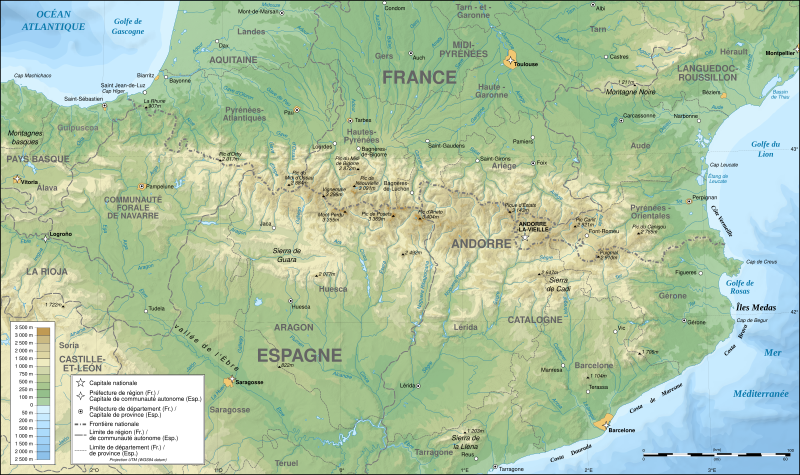
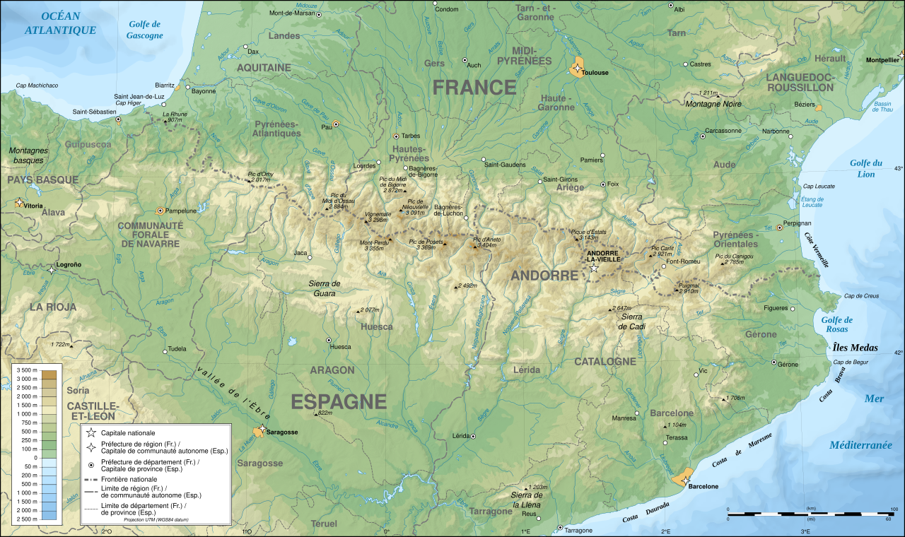
Detailed map of large dimension. For a better viewing, click on the link of the image above.
Carte détaillée de grande dimension. Pour une visualisation optimale, cliquer sur le lien de l'image ci-dessus.
Muhtasari
| Description |
English: Topographic map in French of the Pyrenees mountains.
Note: The shaded relief is a raster image embedded in the SVG file. Français : Carte topographique des Pyrénées en francais.
Note : Le relief ombré est une image bitmap embarquée dans le fichier SVG. Português: Mapa topográfico (em Francês) dos Pirenéus.
Español: Mapa topográfico (en francés) de los Pirineos.
UTM projection; WGS84 datum; shaded relief (composite image of N-W, W and N lightning positions);
|
||
| SVG genesis | |||
| Tarehe | May 2007 (modified September 2008) | ||
| Chanzo |
Own work;
|
||
| Muumbaji | |||
| Ruhusa (Kutumia faili tena) |
|
||
| Georeferencing | If inappropriate please set warp_status = skip to hide. | ||
| Matoleo mengine |
[]
|


Assessment
|

Picha hii ilikuwa picha ya siku ya 1 Agosti 2007. Maelezo mafupi yalikuwa: English: Topographic map in French of the Pyrenees mountains. Lugha nyingine:
Čeština: Francouzská mapa pohoří Pyreneje Dansk: Topografisk kort over Pyrenæerne på fransk. English: Topographic map in French of the Pyrenees mountains. Français : Carte topographique des Pyrénées en français. Magyar: A Pireneusok térképe Nederlands: Franse Topografische kaart van de Pyreneeën Português: Um mapa topográfico em francês, da região dos Pireneus. Română: Hartă topografică a munților Pirinei, Franța. Suomi: Topografinen kartta Ranskasta, Pyreneiden vuorilta. Svenska: Topografisk karta över Pyrenéerna på franska. Русский: Топографическая карта Пиренеев. Українська: Топографічна карта Піренеїв 中文: 法语注释的比利牛斯山地形图 中文(繁體): 庇里牛斯山的法語地形圖 עברית : מפה טופוגרפית בצרפתית של הרי הפירינאים |
Hatimiliki

|
Ruhusa inakubalika kunakili, kusambaza na/au kurekebisha chini ya matakwa ya GNU Free Documentation License, Toleo 1.2 au toleo lolote lile la baadaye ambalo litachapishwa na Free Software Foundation; lisilo na Sehemu Tofauti, lisilo na Maandishi-Kava-Kwa-Mbele, na lisilo na Maandishi-Kava-Kwa -Nyuma. Nakala ya hatimiliki inajumlishwa kwenye sehemu ilioitwa GNU Free Documentation License. |
| Faili hii imeidhinishwa chini ya Creative Commons Attribution- Attribution-Share Alike 3.0 Unported leseni. | ||
shiriki sawa – Ukichanganya, kubadilisha, au kujenga juu ya nyenzo, lazima usambaze michango yako chini ya same or compatible license kama ya awali. | ||
| This licensing tag was added to this file as part of the GFDL licensing update. |
- Uko huru:
- kushiriki – kunakili na kusambaza kazi hiyo
- kwa remix – kurekebisha kazi
- Chini ya masharti yafuatayo:
- sifa – Ni lazima utoe mkopo unaofaa, utoe kiungo cha leseni, na uonyeshe ikiwa mabadiliko yalifanywa. Unaweza kufanya hivyo kwa njia yoyote inayofaa, lakini si kwa njia yoyote inayopendekeza mtoa leseni akuidhinishe wewe au matumizi yako.
Historia ya faili
Bonyeza tarehe/saa kuona faili kama ilivyoonekana wakati huo.
| Tarehe/Saa | Picha ndogo | Vipimo | Mtumiaji | Maelezo | |
|---|---|---|---|---|---|
| sasa hivi | 00:05, 14 Desemba 2012 | | 3,200 × 1,900 (6.3 MB) | Benh | uses Helvetica over Arial when available. |
| 15:49, 23 Septemba 2008 |  | 3,200 × 1,900 (6.3 MB) | Sting | Using ETOPO1 data for bathymetry; new standard colors | |
| 00:25, 2 Julai 2007 |  | 3,200 × 1,900 (5.9 MB) | Sting | + projection info in key ; + major cities areas ; some corrections in the rivers | |
| 20:30, 25 Juni 2007 |  | 3,200 × 1,900 (5.88 MB) | Sting | + key for borders | |
| 21:18, 31 Mei 2007 |  | 3,200 × 1,900 (5.88 MB) | Sting | Some corrections | |
| 18:23, 30 Mei 2007 |  | 3,200 × 1,900 (5.88 MB) | Sting | {{Information |Description=Topographic map in French of the Pyrenees mountains |Source=Own work ;<br/>Topographic map : [http://www2.jpl.nasa.gov/srtm NASA Shuttle Radar Topography Mission] (SRTM3 v.2) (public domain) edited with [http:// |
Matumizi ya faili
Ukurasa huu umeunganishwa na faili hili:
Matumizi ya faili ulimwenguni
Wiki nyingine hutumia faili hizi:
- Matumizi kwa af.wikipedia.org
- Matumizi kwa an.wikipedia.org
- Matumizi kwa ar.wikipedia.org
- Matumizi kwa azb.wikipedia.org
- Matumizi kwa ba.wikipedia.org
- Matumizi kwa bs.wikipedia.org
- Matumizi kwa ca.wikipedia.org
- Matumizi kwa cs.wikipedia.org
- Matumizi kwa en.wikipedia.org
- Matumizi kwa eo.wikipedia.org
- Matumizi kwa es.wikipedia.org
- Matumizi kwa et.wikipedia.org
- Matumizi kwa eu.wikipedia.org
- Matumizi kwa fa.wikipedia.org
- Matumizi kwa fi.wikipedia.org
- Matumizi kwa fr.wikipedia.org
- Ariège (département)
- Aude (département)
- Andorre
- Sentier de grande randonnée 10
- Haute-Garonne
- Hautes-Pyrénées
- Pyrénées-Orientales
- Pyrénées
- Liste des communes des Hautes-Pyrénées
- Discussion:Liste des communes des Hautes-Pyrénées
- Pau
- Béarn
- Bayonne
- Tarbes
- Adour
- Ariège (rivière)
- Vals (Ariège)
- Catalogne
- Aragon (communauté autonome)
- Huesca
- Bizanos
- Pays basque
- Discussion:Béarn
- Discussion:Pau
- Val d'Aran
- Prades (Pyrénées-Orientales)
- Haute-Navarre
- Lugdunum Convenarum
- Lourdes
Tazama matumizi zaidi ya kimataifa ya faili hii.