
Faili:Ph physical map.png
Ukubwa wa hakikisho: piseli 382 × 598. Ukubwa zingine: piseli 153 × 240 | piseli 600 × 940.
Faili halisi (piseli 600 × 940, saizi ya faili: 114 KB, aina ya MIME: image/png)
| Faili hili linatoka Wikimedia Commons. Maelezo yapo kule kwenye ukurasa wake wa maelezo unaonekana hapo chini.
|
Muhtasari
| Maelezo |
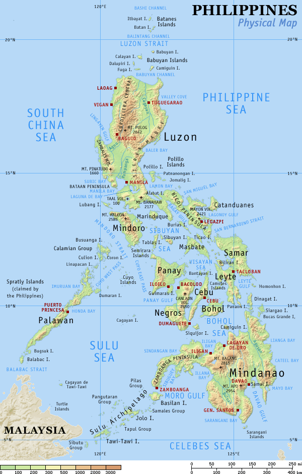
English: Physical map of the Philippines, showing all the major and some minor islands, bodies of water, mountains, and some major cities. |
| Tarehe | |
| Chanzo | Kazi yangu |
| Mwandishi | Eugene Alvin Villar (seav) |
| Matoleo mengine |
|


|

|
This map image could be re-created using vector graphics as an SVG file. This has several advantages; see Commons:Media for cleanup for more information. If an SVG form of this image is available, please upload it and afterwards replace this template with
{{vector version available|new image name}}.
It is recommended to name the SVG file “Ph physical map.svg”—then the template Vector version available (or Vva) does not need the new image name parameter. |
Hatimiliki
I, the copyright holder of this work, hereby publish it under the following licenses:
This file is licensed under the Creative Commons Attribution-Share Alike 4.0 International license.
- Uko huru:
- kushiriki – kunakili na kusambaza kazi hiyo
- kwa remix – kurekebisha kazi
- Chini ya masharti yafuatayo:
- sifa – Ni lazima utoe mkopo unaofaa, utoe kiungo cha leseni, na uonyeshe ikiwa mabadiliko yalifanywa. Unaweza kufanya hivyo kwa njia yoyote inayofaa, lakini si kwa njia yoyote inayopendekeza mtoa leseni akuidhinishe wewe au matumizi yako.
Faili hii imeidhinishwa chini ya Creative Commons Attribution- Attribution-Share Alike 3.0 Unported leseni.
- Uko huru:
- kushiriki – kunakili na kusambaza kazi hiyo
- kwa remix – kurekebisha kazi
- Chini ya masharti yafuatayo:
- sifa – Ni lazima utoe mkopo unaofaa, utoe kiungo cha leseni, na uonyeshe ikiwa mabadiliko yalifanywa. Unaweza kufanya hivyo kwa njia yoyote inayofaa, lakini si kwa njia yoyote inayopendekeza mtoa leseni akuidhinishe wewe au matumizi yako.

|
Ruhusa inakubalika kunakili, kusambaza na/au kurekebisha chini ya matakwa ya GNU Free Documentation License, Toleo 1.2 au toleo lolote lile la baadaye ambalo litachapishwa na Free Software Foundation; lisilo na Sehemu Tofauti, lisilo na Maandishi-Kava-Kwa-Mbele, na lisilo na Maandishi-Kava-Kwa -Nyuma. Nakala ya hatimiliki inajumlishwa kwenye sehemu ilioitwa GNU Free Documentation License. |
Unaweza kuchagua leseni ya chaguo lako.
Kumbukumbu ya upakizaji wa asili
The original description page was here. All following user names refer to en.wikipedia.
| Date | User | File size | History log |
|---|---|---|---|
| 2005-08-29 15:09 | Riumplus | (117068 bytes) | Removed unused colours in the PNG palette, losslessly shrinking file size by 4% |
| 2004-07-25 09:09 | Guanaco | (121976 bytes) | optimize |
| 2003-08-17 08:46 | Seav | (122906 bytes) | Updated map with more details |
| 2003-06-20 11:13 | Seav | (130670 bytes) | Physical map of the Philippines. |
Historia ya faili
Bonyeza tarehe/saa kuona faili kama ilivyoonekana wakati huo.
| Tarehe/Saa | Picha ndogo | Vipimo | Mtumiaji | Maelezo | |
|---|---|---|---|---|---|
| sasa hivi | 22:05, 1 Machi 2007 | | 600 × 940 (114 KB) | Tene~commonswiki | Optimised (0) |
| 17:21, 16 Septemba 2005 |  | 600 × 940 (114 KB) | Saperaud~commonswiki | Physical map of the Philippines, showing all the major and some minor islands, bodies of water, mountains, and some major cities. See blank version which can be used for other language |
Matumizi ya faili
Kurasa hizi 2 zimeunganishwa na faili hili:
Matumizi ya faili ulimwenguni
Wiki nyingine hutumia faili hizi:
- Matumizi kwa af.wikipedia.org
- Matumizi kwa an.wikipedia.org
- Matumizi kwa ba.wikipedia.org
- Matumizi kwa bg.wikipedia.org
- Matumizi kwa bn.wikipedia.org
- Matumizi kwa br.wikipedia.org
- Matumizi kwa ca.wikipedia.org
- Matumizi kwa cbk-zam.wikipedia.org
- Matumizi kwa ceb.wikipedia.org
- Matumizi kwa da.wikipedia.org
- Matumizi kwa de.wikipedia.org
- Matumizi kwa en.wikipedia.org
- User:Seav
- List of islands of the Philippines
- Template:Pic of the day/Archive1
- Ecoregions in the Philippines
- Wikipedia:Picture of the day/June 2004
- Manila Trench
- Wikipedia:Picture of the day/April 2005
- Wikipedia:POTD/April 13, 2005
- Wikipedia:Picture of the day/April 13, 2005
- User:Cyde/Featured pictures
- Wikipedia:Featured picture candidates/delist/2006
- Portal:Maps/Selected picture
- User talk:Howard the Duck/Archive3
- Wikipedia:Featured picture candidates/delist/2007
- Island groups of the Philippines
- Wikipedia:Featured picture candidates/delist/Ph physical map.png
- List of potentially active volcanoes in the Philippines
- User:Wittylama/FP Deletion
- Extreme points of the Philippines
- Portal:Maps/Selected picture/1
- Outline of the Philippines
- List of ultras of the Philippines
- List of active volcanoes in the Philippines
- List of inactive volcanoes in the Philippines
- Philippine Mobile Belt
- List of rivers of the Philippines
- Benham Rise
- Philippine Fault System
- List of lighthouses in the Philippines
- Wikipedia:Featured picture candidates/delist/2010
- Marikina Valley Fault System
- Wikipedia:Featured picture candidates/delist/File:Ph physical map.png
- List of mountains in the Philippines
- List of lakes of the Philippines
- List of protected areas of the Philippines
- List of bays of the Philippines
- List of headlands of the Philippines
Tazama matumizi zaidi ya kimataifa ya faili hii.