
Faili:Noord-Brabant position.svg

Size of this PNG preview of this SVG file: piseli 200 × 236. Ukubwa zingine: piseli 203 × 240 | piseli 407 × 480 | piseli 651 × 768 | piseli 868 × 1,024 | piseli 1,736 × 2,048.
Faili halisi (faili la SVG, husemwa kuwa piseli 200 × 236, saizi ya faili: 158 KB)
| Faili hili linatoka Wikimedia Commons. Maelezo yapo kule kwenye ukurasa wake wa maelezo unaonekana hapo chini.
|
Muhtasari
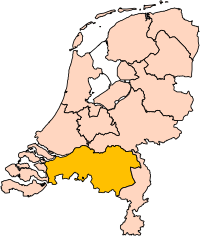
| Maelezo | Location of the province of Noord-Brabant (North Brabant) in the Netherlands. |
| Tarehe | |
| Chanzo | Own work, based on freely available GIS data |
| Mwandishi | User:Mtcv |
| Ruhusa (Kutumia faili tena) |
Data: attribution required; my work: PD |
| Matoleo mengine | I attempted to make an svg version of Image:Noord Brabant-Position.png (with less simplified boundaries) |
Clickable version

Hatimiliki

|
The copyright holder of this file, Centraal Bureau voor de Statistiek, allows anyone to use it for any purpose, provided that the copyright holder is properly attributed. Redistribution, derivative work, commercial use, and all other use is permitted. |
|
|
| Annotations | This image is annotated: View the annotations at Commons |


Historia ya faili
Bonyeza tarehe/saa kuona faili kama ilivyoonekana wakati huo.
| Tarehe/Saa | Picha ndogo | Vipimo | Mtumiaji | Maelezo | |
|---|---|---|---|---|---|
| sasa hivi | 17:20, 2 Machi 2019 | | 200 × 236 (158 KB) | Thayts | update |
| 00:49, 3 Oktoba 2006 |  | 200 × 236 (158 KB) | Mtcv | {{Information| |Description=Location of the province of Noord-Holland (North Holland) in the Netherlands. |Source=Own work, based on freely available GIS data |Date=2006-10-03 |Author=User:Mtcv |Permission=Data: attribution required; my work: PD |othe |
Matumizi ya faili
Ukurasa huu umeunganishwa na faili hili:
Matumizi ya faili ulimwenguni
Wiki nyingine hutumia faili hizi:
- Matumizi kwa ar.wikipedia.org
- شمال بربنت
- آيندهوفن
- بريدا
- بارله ناساو
- تيلبورخ
- سيرتوخيمبوس
- قالب:بلديات شمال برابنت
- آلبورخ
- ألفن- كام
- أستن
- بيرخ آيك
- فيلدهوفن
- بيرخن أوب زووم
- بيرنهيزه
- بيست (هولندا)
- بلادل
- بوكل
- بوكسمير
- بوكستل
- كرانندونك
- كاوك
- دورنه
- دونجن
- دريميلين
- إيرسل
- إيتن- لور
- خيرتراودنبيرخ
- خيلدروب- ميرلو
- خيميرت- باكل
- خيلزه آن راين
- خورلا
- خرافه (هولندا)
- هارن (شمال برابنت)
- هالدربيرخه
- هيزه- لينده
- هيلموند
- هوسدن
- هيلفارينبيك
- لاربيك
- لانديرد
- لوب أوب زند
- مل آن سينت هوبرت
- موردايك
- نونن (خيرفن آن نيدرفيتن)
- أويرشخوت
- أويسترفايك
- أوسترهاوت
- أوس (هولندا)
- روسل- دي ميردن
- روسيندال
Tazama matumizi zaidi ya kimataifa ya faili hii.