
Faili:Mount Tambora Volcano, Sumbawa Island, Indonesia.jpg

Faili halisi (piseli 4,256 × 2,828, saizi ya faili: 2.29 MB, aina ya MIME: image/jpeg)
| Faili hili linatoka Wikimedia Commons. Maelezo yapo kule kwenye ukurasa wake wa maelezo unaonekana hapo chini.
|
Muhtasari
| Maelezo |
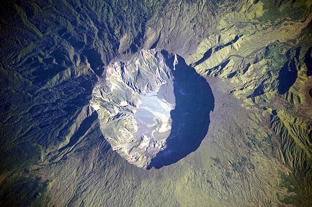
Bahasa Indonesia: Foto astronot ini menggambarkan kaldera puncak gunung Tambora. Kaldera ini berdiameter 6 km dan terbentuk dengan dalam 1.100 m ketika puncak Gunung Tambora yang berketinggian kira-kira 4.000 m telah tidak ada, dan ruangan magma di bawahnya menjadi kosong setelah letusan tahun 1815. Saat ini dasar kawah menjadi lokasi sebuah danau air tawar musiman, deposit sedimen yang belum lama, aliran lava kecil, dan kubah yang terbentuk selama abad kesembilan belas dan kedua puluh. Deposit tephra yang berlapis terlihat di sepanjang sisi barat laut bibir kawah. Fumarol aktif, atau ventilasi uap, masih ada di kaldera.
English: This detailed astronaut photograph depicts the summit caldera of the volcano. The huge caldera—6 kilometers in diameter and 1,100 meters deep—formed when Tambora’s estimated 4,000-meter-high peak was removed, and the magma chamber below emptied during the 1815 eruption. Today the crater floor is occupied by an ephemeral freshwater lake, recent sedimentary deposits, and minor lava flows and domes emplaced during the nineteenth and twentieth centuries. Layered tephra deposits are visible along the north-western crater rim. Active fumaroles, or steam vents, still exist in the caldera.
Français : Photographie de la caldera sommitale du mont Tambora, en Indonésie. Cette caldera est immense, avec 6 km de diamètre et 1000 m de profondeur. Sa formation date de l'éruption de 1815, qui est l'éruption volcanique la plus importante de l'histoire. Avant l'éruption, le Tambora formait un pic d'une altitude d'environ 4000 m. Aujourd'hui, les lèvres de la caldera sont à 2500 m d'altitude. Le fond de la caldera est occupé par un lac temporaire, des coulées de laves provenant d'éruptions mineures et des fumeroles.
Deutsch: Krater des Tambora
Русский: Эта фотография подробно показывает кальдеру вулкана Тамбора, имеющую 6 — 7 километров в диаметре. Она образовалась в результате катастрофического извержения 1815 года, когда верхняя часть вулкана обрушилась из-за опустения магматической камеры под ним. Сегодня внутри кальдеры находится небольшое пресноводное озеро, лавовые купола, а в северо-западной части кратера имеются многослойные отложения тефры. Кроме того кальдере присуща фумарольная активность.
|
||||||||||||||||||||||||||||||||||||||||||||||||||||||
| Tarehe | Published 2009-07-19. Taken 2009-03-06. | ||||||||||||||||||||||||||||||||||||||||||||||||||||||
| Chanzo | Image and and English description: Mount Tambora Volcano, Sumbawa Island, Indonesia, NASA Earth Observatory. 2nd version: Transferred from de.wikipedia to Commons.; originally from https://eol.jsc.nasa.gov/SearchPhotos/photo.pl?mission=ISS020&roll=E&frame=06563 | ||||||||||||||||||||||||||||||||||||||||||||||||||||||
| Mwandishi | This image was taken by the NASA Expedition 20 crew. | ||||||||||||||||||||||||||||||||||||||||||||||||||||||
| Camera location | | View this and other nearby images on: OpenStreetMap |
|---|
This image or video was catalogued by Johnson Space Center of the United States National Aeronautics and Space Administration (NASA) under Photo ID: ISS020-E-6563. This tag does not indicate the copyright status of the attached work. A normal copyright tag is still required. See Commons:Licensing. Other languages:
|
|

Hatimiliki
| This file is in the public domain in the United States because it was solely created by NASA. NASA copyright policy states that "NASA material is not protected by copyright unless noted". (See Template:PD-USGov, NASA copyright policy page or JPL Image Use Policy.) | ||
 |
Warnings:
|
Original upload log (2nd version)
- 2009-07-23 01:35 Geoethno 1440×960× (469914 bytes) {{Information |Beschreibung = Krater des Tambora |Quelle = http://earthobservatory.nasa.gov/images/imagerecords/39000/39412/ISS020-E-06563_l
Historia ya faili
Bonyeza tarehe/saa kuona faili kama ilivyoonekana wakati huo.
| Tarehe/Saa | Picha ndogo | Vipimo | Mtumiaji | Maelezo | |
|---|---|---|---|---|---|
| sasa hivi | 12:55, 24 Februari 2011 | | 4,256 × 2,828 (2.29 MB) | Originalwana | higher res |
| 17:37, 15 Aprili 2010 |  | 1,440 × 960 (619 KB) | Rosenzweig | Reverted to version as of 11:04, 19 July 2009. Back to Commons version. | |
| 17:37, 15 Aprili 2010 |  | 1,440 × 960 (459 KB) | Rosenzweig | different version from de.wp | |
| 11:04, 19 Julai 2009 |  | 1,440 × 960 (619 KB) | Originalwana | {{Information |Description={{en|1=This detailed astronaut photograph depicts the summit caldera of the volcano. The huge caldera—6 kilometres in diameter and 1,100 meters deep—formed when Tambora’s estimated 4,000-meter-high peak was removed, and th |
Matumizi ya faili
Ukurasa huu umeunganishwa na faili hili:
Matumizi ya faili ulimwenguni
Wiki nyingine hutumia faili hizi:
- Matumizi kwa af.wikipedia.org
- Matumizi kwa ar.wikipedia.org
- Matumizi kwa ast.wikipedia.org
- Matumizi kwa ban.wikipedia.org
- Matumizi kwa be.wikipedia.org
- Matumizi kwa bn.wikipedia.org
- Matumizi kwa ca.wikipedia.org
- Matumizi kwa cs.wikipedia.org
- Matumizi kwa da.wikipedia.org
- Matumizi kwa de.wikipedia.org
- Matumizi kwa en.wikipedia.org
- Matumizi kwa en.wikiversity.org
- Matumizi kwa en.wikivoyage.org
- Matumizi kwa eo.wikipedia.org
- Matumizi kwa es.wikipedia.org
- Matumizi kwa fa.wikipedia.org
- Matumizi kwa fr.wikipedia.org
- Matumizi kwa fr.wiktionary.org
- Matumizi kwa gl.wikipedia.org
- Matumizi kwa gor.wikipedia.org
- Matumizi kwa he.wikipedia.org
- Matumizi kwa hr.wikipedia.org
- Matumizi kwa id.wikipedia.org
- Gunung Tambora
- Wikipedia:Hari ini dalam sejarah/April
- Wikipedia:Gambar pilihan/2011
- Wikipedia:Gambar pilihan/Usulan/2011/54 Intro
- Wikipedia:Gambar pilihan/54 2011
- Templat:Hari Ini Dalam Sejarah/April
- Wikipedia:Gambar pilihan/Tempat/Landskap
- Wikipedia:Arsip halaman utama/2023/04/10
- Wikipedia:Arsip halaman utama/2024/04/10
- Matumizi kwa it.wikipedia.org
- Matumizi kwa ja.wikipedia.org
- Matumizi kwa ka.wikipedia.org
- Matumizi kwa kk.wikipedia.org
Tazama matumizi zaidi ya kimataifa ya faili hii.