
Faili:Iron Curtain map.svg

Size of this PNG preview of this SVG file: piseli 560 × 599. Ukubwa zingine: piseli 224 × 240 | piseli 449 × 480 | piseli 718 × 768 | piseli 957 × 1,024 | piseli 1,914 × 2,048 | piseli 645 × 690.
Faili halisi (faili la SVG, husemwa kuwa piseli 645 × 690, saizi ya faili: 322 KB)
| Faili hili linatoka Wikimedia Commons. Maelezo yapo kule kwenye ukurasa wake wa maelezo unaonekana hapo chini.
|
Muhtasari
| Maelezo |
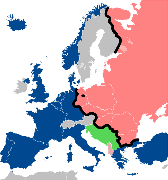
Lëtzebuergesch: Kaart vum Westen an dem Ostblock an Europa während dem Kale Krich.
"Eise Rido"
Neutral Länner
|
||
| Tarehe | |||
| Chanzo |
Travail personnel (own work). Sources:
|
||
| Mwandishi | Sémhur | ||
| Matoleo mengine |
File:Iron Curtain map alternative.svg (Same, but with Yugoslavia on the Eastern side of the Iron Curtain.) | ||
| Sifa (required by the license) | © Sémhur / Wikimedia Commons / | ||
| SVG | W3C-validity not checked.
|
||
| Graphic Lab |

| Camera location | | View this and other nearby images on: OpenStreetMap |
|---|
Hatimiliki
I, the copyright holder of this work, hereby publish it under the following licenses:
| Copyleft: This work of art is free; you can redistribute it and/or modify it according to terms of the Free Art License. You will find a specimen of this license on the Copyleft Attitude site as well as on other sites. |
This file is licensed under the Creative Commons Attribution-Share Alike 4.0 International, 3.0 Unported, 2.5 Generic, 2.0 Generic and 1.0 Generic license.
- Uko huru:
- kushiriki – kunakili na kusambaza kazi hiyo
- kwa remix – kurekebisha kazi
- Chini ya masharti yafuatayo:
- sifa – Ni lazima utoe mkopo unaofaa, utoe kiungo cha leseni, na uonyeshe ikiwa mabadiliko yalifanywa. Unaweza kufanya hivyo kwa njia yoyote inayofaa, lakini si kwa njia yoyote inayopendekeza mtoa leseni akuidhinishe wewe au matumizi yako.
Unaweza kuchagua leseni ya chaguo lako.
Historia ya faili
Bonyeza tarehe/saa kuona faili kama ilivyoonekana wakati huo.
| Tarehe/Saa | Picha ndogo | Vipimo | Mtumiaji | Maelezo | |
|---|---|---|---|---|---|
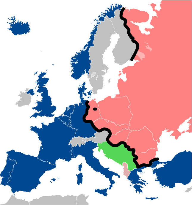
| sasa hivi | 13:26, 15 Desemba 2022 | | 645 × 690 (322 KB) | PhotographyEdits | Extend the Iron Curtain eastwards of Yugoslavia. Even though Yugoslavia was not really considered part of the West, the currenet map gives the false impression that there was a huge gap in the Iron Curtain, which wasn't the case. |
| 00:56, 23 Julai 2022 |  | 645 × 690 (321 KB) | Kwamikagami | NATO blue, #004990 | |
| 20:30, 30 Machi 2019 |  | 645 × 690 (321 KB) | Sémhur | Reverted to version as of 07:07, 27 May 2014 (UTC). Albania leaves the Waras Pack in middle of cold war; this is why it's shown wtih stripes. | |
| 09:18, 24 Machi 2019 |  | 512 × 548 (123 KB) | Hakuli | Albania leaves the Waras Pack in middle of cold war | |
| 07:07, 27 Mei 2014 |  | 645 × 690 (321 KB) | Sémhur | Valid SVG | |
| 13:51, 16 Novemba 2010 |  | 645 × 690 (321 KB) | Sémhur | Added Iron Curtain between Bulgaria and Greece & Turkey. | |
| 16:57, 27 Septemba 2008 |  | 645 × 690 (321 KB) | Sémhur | Correcting mistake : Austria wasn't in NATO. | |
| 10:51, 31 Mei 2008 |  | 645 × 690 (330 KB) | Sémhur | {{Information |Description={{en|1=Map of the Iron Curtain in Europe.}} {{fr|1=Carte du rideau de fer en Europe.}} {{es|1=Mapa del Telón de Acero en Europa.}} |Source=Travail personnel (ow |
Matumizi ya faili
Ukurasa huu umeunganishwa na faili hili:
Matumizi ya faili ulimwenguni
Wiki nyingine hutumia faili hizi:
- Matumizi kwa af.wikipedia.org
- Matumizi kwa als.wikipedia.org
- Matumizi kwa ar.wikipedia.org
- Matumizi kwa ast.wikipedia.org
- Matumizi kwa azb.wikipedia.org
- Matumizi kwa az.wikipedia.org
- Matumizi kwa ba.wikipedia.org
- Matumizi kwa be-tarask.wikipedia.org
- Matumizi kwa be.wikipedia.org
- Matumizi kwa bg.wikipedia.org
- Matumizi kwa br.wikipedia.org
- Matumizi kwa bs.wikipedia.org
- Matumizi kwa ca.wikipedia.org
- Matumizi kwa cs.wikipedia.org
- Matumizi kwa cy.wikipedia.org
- Matumizi kwa da.wikipedia.org
- Matumizi kwa de.wikipedia.org
- Matumizi kwa el.wikipedia.org
- Matumizi kwa el.wiktionary.org
- Matumizi kwa en.wikipedia.org
- Matumizi kwa en.wikibooks.org
- Matumizi kwa en.wikiquote.org
- Matumizi kwa en.wiktionary.org
Tazama matumizi zaidi ya kimataifa ya faili hii.