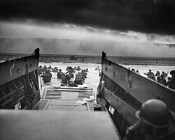
Faili:Into the Jaws of Death 23-0455M edit (cropped 4-3).jpg

Faili halisi (piseli 2,963 × 2,222, saizi ya faili: 3.36 MB, aina ya MIME: image/jpeg)
| Faili hili linatoka Wikimedia Commons. Maelezo yapo kule kwenye ukurasa wake wa maelezo unaonekana hapo chini.
|
Muhtasari
| Robert F. Sargent: Into the Jaws of Death
|
|||||||||||||||||||||||||||
|---|---|---|---|---|---|---|---|---|---|---|---|---|---|---|---|---|---|---|---|---|---|---|---|---|---|---|---|
| Artist |
Chief Photographer's Mate (CPHoM) Robert F. Sargent |
||||||||||||||||||||||||||
| Jina |
English: Second World War: Europe; "Into the Jaws of Death — U.S. Troops wading through water and Nazi gunfire”, circa 1944-06-06.
Deutsch: Zweiter Weltkrieg, Europa; "In den Rachen des Todes: US-Truppen-Wasserweg unter Nazi-Kugeln." Das Foto wurde am 6. Juni 1944 gegen 7:40 Uhr aufgenommen.
Español: Segunda Guerra Mundial, Europa. "Entre las fauces de la muerte: las tropas estadounidenses caminan por el agua bajo los proyectiles nazis". Foto tomada alrededor de las 07:40 de la mañana circa del 6 de junio de 1944.
Français : Seconde Guerre mondiale en Europe; « Into the Jaws of Death ». Des fantassins américains débarquent d'un Landing Craft Vehicle & Personnel sous le feu de l'armée allemande. Photo prise circa 6 juin 1944.
Italiano: Seconda guerra mondiale, Europa. "Tra le fauci della morte: le truppe statunitensi Waterwalk sotto i proiettili nazisti". Foto scattata intorno alle 7:40 del 6 giugno 1944. |
||||||||||||||||||||||||||
| Sehemu ya |
Records of the U.S. Coast Guard (NAID 355) |
||||||||||||||||||||||||||
| Object type |
picha mgando |
||||||||||||||||||||||||||
| Utanzu |
war photography |
||||||||||||||||||||||||||
| Maelezo |
English: A LCVP (Landing Craft, Vehicle, Personnel) from the U.S. Coast Guard-manned USS Samuel Chase disembarks troops of Company A, 16th Infantry, 1st Infantry Division (the Big Red One) wading onto the Fox Green section of Omaha Beach (Calvados, Basse-Normandie, France) on the morning of June 6, 1944. American soldiers encountered the newly formed German 352nd Division when landing. During the initial landing two-thirds of Company E became casualties.
Español: Un LCVP (Lancha de Desembarco, Vehículo, Personal) del USS Samuel Chase, tripulado por la Guardia Costera de los EE. UU., desembarca tropas de la Compañía A, 16.° de Infantería, 1.° División de Infantería (la Roja Grande) vadeando hacia la sección Fox Green de la playa de Omaha (Calvados, Basse-Normandie, Francia) en la mañana del 6 de junio de 1944. Los soldados estadounidenses se encontraron con la recién formada 352.° División alemana al aterrizar. Durante el aterrizaje inicial, dos tercios de la Compañía E se convirtieron en bajas. |
||||||||||||||||||||||||||
| Tarehe | 6 Juni 1944, 08:30 | ||||||||||||||||||||||||||
| Mkusanyiko |
institution QS:P195,Q518155 |
||||||||||||||||||||||||||
| Current location |
institution QS:P195,Q518155
Franklin D. Roosevelt Library (NLFDR), 4079 Albany Post Road, Hyde Park, NY, 12538-1999. |
||||||||||||||||||||||||||
| Accession number |
NAIL Control Number: NLR-PHOCO-A-7298 |
||||||||||||||||||||||||||
| Place of creation |
Ufaransa |
||||||||||||||||||||||||||
| Notes |
The coordinates are estimated values. For further reading see: www.famouspictures.org. Identification of the soldier via: The Free Lance-Star - June 6, 1984. See also a map of the Fox Green section at Omaha Beach. The following changes were applied to this restoration: global sharpness increased, filaments/dust/dirt removed, levels adjusted, cropped. |
||||||||||||||||||||||||||
| Udhibiti wa mamlaka | |||||||||||||||||||||||||||
| Source/Photographer |
|
||||||||||||||||||||||||||
| Matoleo mengine |
|
||||||||||||||||||||||||||
| Camera location | 49° 21′ 59.61″ N, 0° 49′ 56.33″ W | View this and other nearby images on: OpenStreetMap |
|---|
| Annotations InfoField | This image is annotated: View the annotations at Commons |
Hatimiliki
| Public domainPublic domainfalsefalse |
This image or file is a work of a United States Coast Guard service personnel or employee, taken or made as part of that person's official duties. As a work of the U.S. federal government, the image or file is in the public domain (17 U.S.C. § 101 and § 105, USCG main privacy policy and specific privacy policy for its imagery server).
العربية ∙ English ∙ italiano ∙ 日本語 ∙ македонски ∙ മലയാളം ∙ русский ∙ sicilianu ∙ Türkçe ∙ українська ∙ Tiếng Việt ∙ +/− |
Assessment
Captions
Items portrayed in this file
depicts Kiingereza
Into the Jaws of Death Kiingereza
copyright status Kiingereza
public domain Kiingereza
coordinates of the point of view Kiingereza
49°21'59.605"N, 0°49'56.330"W
media type Kiingereza
image/jpeg
Into the Jaws of Death Kiingereza
Historia ya faili
Bonyeza tarehe/saa kuona faili kama ilivyoonekana wakati huo.
| Tarehe/Saa | Picha ndogo | Vipimo | Mtumiaji | Maelezo | |
|---|---|---|---|---|---|
| sasa hivi | 19:22, 1 Oktoba 2022 |  | 2,963 × 2,222 (3.36 MB) | KOKUYO | File:Into the Jaws of Death 23-0455M edit.jpg cropped 7 % vertically using CropTool with precise mode. |
Matumizi ya faili
Ukurasa huu umeunganishwa na faili hili:
Matumizi ya faili ulimwenguni
Wiki nyingine hutumia faili hizi:
- Matumizi kwa zh.wikipedia.org
Data juu
Faili hili lina maarifa mengine, yamkini kutoka kemra au skana iliyotumiwa kulitengeneza au kuliandaa kwa tarakilishi.
Kama faili limebadilishwa kutoka hali yake ya awali, inawezekana kwamba vipengele kadhaa vitakuwa tofauti kuliko hali ya picha ilivyo sasa.
| Jina la picha |
|
|---|---|
| Mwandishi | NARA |
| Upana | 3,000 px |
| Urefu | 2,421 px |
| Bits per component | 8 |
| Compression scheme | Uncompressed |
| Pixel composition | Black and white (Black is 0) |
| Orientation | Kawaida |
| Number of components | 1 |
| Horizontal resolution | 300 dpi |
| Vertical resolution | 300 dpi |
| Bidhaa pepe inayotumika | Adobe Photoshop CS5 Windows |
| Tarehe na saa ya kubadilisha faili | 18:44, 19 Oktoba 2011 |
| Color space | Uncalibrated |
| Date and time of digitizing | 19:25, 29 Januari 2011 |
| Date metadata was last modified | 20:44, 19 Oktoba 2011 |
| Unique ID of original document | xmp.did:1EEFFFC1E82BE0119A51925AAC29F621 |


