
Faili:Egypt NK edit.svg

Size of this PNG preview of this SVG file: piseli 512 × 599. Ukubwa zingine: piseli 205 × 240 | piseli 410 × 480 | piseli 656 × 768 | piseli 875 × 1,024 | piseli 1,749 × 2,048 | piseli 1,282 × 1,501.
Faili halisi (faili la SVG, husemwa kuwa piseli 1,282 × 1,501, saizi ya faili: 252 KB)
| Faili hili linatoka Wikimedia Commons. Maelezo yapo kule kwenye ukurasa wake wa maelezo unaonekana hapo chini.
|
Muhtasari
| Maelezo |
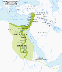
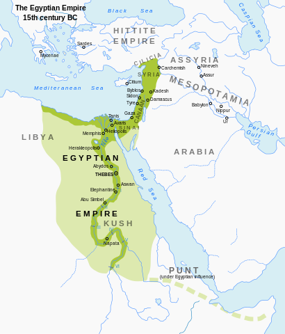
English: Map of Egypt's territorial control during the New Kingdom. Modified from en:Image:Egypt_1450_BC.svg; includes a more muted color scheme. |
| Tarehe | (UTC) |
| Chanzo | Own work based on: Egypt 1450 BC.svg |
| Mwandishi | ArdadN, Jeff Dahl |
| Matoleo mengine |
[]
|


|
This SVG file contains embedded text that can be translated into your language, using any capable SVG editor, text editor or the SVG Translate tool. For more information see: About translating SVG files. |
Hatimiliki
I, the copyright holder of this work, hereby publish it under the following licenses:
Faili hii imeidhinishwa chini ya Creative Commons Attribution- Attribution-Share Alike 3.0 Unported leseni.
- Uko huru:
- kushiriki – kunakili na kusambaza kazi hiyo
- kwa remix – kurekebisha kazi
- Chini ya masharti yafuatayo:
- sifa – Ni lazima utoe mkopo unaofaa, utoe kiungo cha leseni, na uonyeshe ikiwa mabadiliko yalifanywa. Unaweza kufanya hivyo kwa njia yoyote inayofaa, lakini si kwa njia yoyote inayopendekeza mtoa leseni akuidhinishe wewe au matumizi yako.

|
Ruhusa inakubalika kunakili, kusambaza na/au kurekebisha chini ya matakwa ya GNU Free Documentation License, Toleo 1.2 au toleo lolote lile la baadaye ambalo litachapishwa na Free Software Foundation; lisilo na Sehemu Tofauti, lisilo na Maandishi-Kava-Kwa-Mbele, na lisilo na Maandishi-Kava-Kwa -Nyuma. Nakala ya hatimiliki inajumlishwa kwenye sehemu ilioitwa GNU Free Documentation License. |
Unaweza kuchagua leseni ya chaguo lako.
Historia ya faili
Bonyeza tarehe/saa kuona faili kama ilivyoonekana wakati huo.
| Tarehe/Saa | Picha ndogo | Vipimo | Mtumiaji | Maelezo | |
|---|---|---|---|---|---|
| sasa hivi | 22:56, 23 Septemba 2023 | | 1,282 × 1,501 (252 KB) | Gaaryeelidmaan | Punt was associated with Myrrh trade, a product found in tip of the Horn https://www.worldhistory.org/punt/ |
| 17:27, 16 Oktoba 2013 |  | 1,282 × 1,501 (252 KB) | Rowanwindwhistler | Reverted to version as of 02:05, 7 July 2008, uploaded by mistake. | |
| 17:24, 16 Oktoba 2013 |  | 1,282 × 1,501 (251 KB) | Rowanwindwhistler | Some labels corrected, square background added to map title. | |
| 02:05, 7 Julai 2008 |  | 1,282 × 1,501 (252 KB) | Jeff Dahl | {{Information |Description={{en|1=Map of Egypt's territorial control during the New Kingdom. Modified from Image:Egypt_1450_BC.svg; includes a more muted color scheme.}} |Source=Modified from Image:Egypt_1450_BC.svg by User:Andrei Nacu, modi |
Matumizi ya faili
Ukurasa huu umeunganishwa na faili hili:
Matumizi ya faili ulimwenguni
Wiki nyingine hutumia faili hizi:
- Matumizi kwa anp.wikipedia.org
- Matumizi kwa ar.wikipedia.org
- Matumizi kwa azb.wikipedia.org
- Matumizi kwa ba.wikipedia.org
- Matumizi kwa be-tarask.wikipedia.org
- Matumizi kwa bg.wikipedia.org
- Matumizi kwa bxr.wikipedia.org
- Matumizi kwa de.wikipedia.org
- Matumizi kwa en.wikipedia.org
- Matumizi kwa eu.wikipedia.org
- Matumizi kwa fa.wikipedia.org
- Matumizi kwa gu.wikipedia.org
- Matumizi kwa he.wikipedia.org
- Matumizi kwa hi.wikipedia.org
- Matumizi kwa hy.wikipedia.org
- Matumizi kwa id.wikipedia.org
- Matumizi kwa incubator.wikimedia.org
- Matumizi kwa ja.wikipedia.org
- Matumizi kwa ka.wikipedia.org
- Matumizi kwa kn.wikipedia.org
- Matumizi kwa ko.wikipedia.org
- Matumizi kwa mg.wikipedia.org
- Matumizi kwa ml.wikipedia.org
- Matumizi kwa mt.wikipedia.org
- Matumizi kwa pnb.wikipedia.org
- Matumizi kwa ru.wikipedia.org
- Matumizi kwa sl.wikipedia.org
- Matumizi kwa sq.wikipedia.org
- Matumizi kwa sv.wikipedia.org
- Matumizi kwa th.wikipedia.org
- Matumizi kwa tl.wikipedia.org
- Matumizi kwa uk.wikipedia.org
- Matumizi kwa ur.wikipedia.org
- Matumizi kwa vep.wikipedia.org
- Matumizi kwa xmf.wikipedia.org
- Matumizi kwa zh.wikipedia.org