
Faili:East-Hem 050ad.jpg

Faili halisi (piseli 3,240 × 1,903, saizi ya faili: 722 KB, aina ya MIME: image/jpeg)
| Faili hili linatoka Wikimedia Commons. Maelezo yapo kule kwenye ukurasa wake wa maelezo unaonekana hapo chini.
|

|
This historical map image could be re-created using vector graphics as an SVG file. This has several advantages; see Commons:Media for cleanup for more information. If an SVG form of this image is available, please upload it and afterwards replace this template with
{{vector version available|new image name}}.
It is recommended to name the SVG file “East-Hem 050ad.svg”—then the template Vector version available (or Vva) does not need the new image name parameter. |


Muhtasari
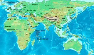
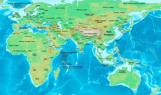
| Maelezo | Eastern Hemisphere in 050 AD. |
| Chanzo | Kazi yangu (For reference information, see the Map Source References section below.) |
| Mwandishi | Thomas Lessman (Contact!) |
| Ruhusa (Kutumia faili tena) |
I, the copyright holder of this work, hereby publish it under the following license: Faili hii imeidhinishwa chini ya Creative Commons Attribution- Attribution-Share Alike 3.0 Unported leseni.
|
| Matoleo mengine | East-Hem_050ad.jpg file history on Wikipedia. |
Map Summary
Original Source URL: http://www.thomaslessman.com/History/images/East-Hem_050ad.jpg.
This map of the Eastern Hemisphere in 050 AD was created by Thomas Lessman, based on information from the sources listed below. This map is free for educational use (see Permission info above). When using this map, please mention that it is available for free at www.WorldHistoryMaps.info.
Map Source References
- Remember, sources often conflict with each other. This map is only as accurate as the information that is available to me. To report any errors or to help further this work, please click here, or email Thomas Lessman at talessman@yis.us
References for information contained in this map:
1. Borders of Europe are mostly derived from the www.Euratlas.com maps of Europe in 001 AD archive copy at the Wayback Machine and from their map of Europe in 100 AD archive copy at the Wayback Machine.
2. Borders of Asian countries are derive from the following sources:
- a - The DK Atlas of World History, 2000 Edition; map of The World in 1 CE, (Pages 42-43) was used for information on several Asian borders in this map.
- b - Korean borders derive from this map of Korea_001.png made by Wikipedia User:Historiographer.
3. Some info also derive from Wikimedia's map of the World_in_50_CE.
4. Much of the information in this map was cross-checked with Bruce Gordon's Regnal Chronologies.
Other Maps by Thomas Lessman
| Maps of the eastern hemisphere showing history
Bold dates are available on Wikimedia or Wikipedia. | ||
| Primeval | ||
| Ancient
|
·| 600 BC | 550 BC | 527 BC | 500 BC |
400 BC | ·| 1 AD | 50 AD | 100 AD | 200 AD | 300 AD | | |
| Medieval |
·| 500 AD | 565 AD | 600 AD | 700 AD | | |
| Modern |
·| 1500 AD | · * For historical maps of the whole world, | |
Historia ya faili
Bonyeza tarehe/saa kuona faili kama ilivyoonekana wakati huo.
| Tarehe/Saa | Picha ndogo | Vipimo | Mtumiaji | Maelezo | |
|---|---|---|---|---|---|
| sasa hivi | 15:53, 9 Mei 2008 | | 3,240 × 1,903 (722 KB) | Talessman | {{Information |Description=Eastern Hemisphere in 050 AD |Source=self-made |Author=Thomas Lessman |Permission={{self|cc-by-sa-3.0}} }} |
Matumizi ya faili
Ukurasa huu umeunganishwa na faili hili:
Matumizi ya faili ulimwenguni
Wiki nyingine hutumia faili hizi:
- Matumizi kwa ar.wikipedia.org
- Matumizi kwa bs.wikipedia.org
- Matumizi kwa ca.wikipedia.org
- Matumizi kwa en.wikipedia.org
- Matumizi kwa es.wikipedia.org
- Matumizi kwa fa.wikipedia.org
- Matumizi kwa fr.wikipedia.org
- Matumizi kwa gl.wikipedia.org
- Matumizi kwa hu.wikipedia.org
- Matumizi kwa inh.wikipedia.org
- Matumizi kwa ja.wikipedia.org
- Matumizi kwa mk.wikipedia.org
- Matumizi kwa pl.wikipedia.org
- Matumizi kwa pnb.wikipedia.org
- Matumizi kwa ro.wikipedia.org
- Matumizi kwa rue.wikipedia.org
- Matumizi kwa ru.wikipedia.org
- Matumizi kwa sh.wikipedia.org
- Matumizi kwa simple.wikipedia.org
- Matumizi kwa si.wikipedia.org
- Matumizi kwa sv.wikipedia.org
- Matumizi kwa ta.wikipedia.org
- Matumizi kwa tl.wikipedia.org
- Matumizi kwa ur.wikipedia.org
- Matumizi kwa vi.wikipedia.org
- Matumizi kwa zh.wikipedia.org