
Faili:Cold war europe military alliances map en.png

Ukubwa wa hakikisho: piseli 582 × 599. Ukubwa zingine: piseli 233 × 240 | piseli 466 × 480 | piseli 746 × 768 | piseli 1,165 × 1,200.
Faili halisi (piseli 1,165 × 1,200, saizi ya faili: 419 KB, aina ya MIME: image/png)
| Faili hili linatoka Wikimedia Commons. Maelezo yapo kule kwenye ukurasa wake wa maelezo unaonekana hapo chini.
|

|
This military map image could be re-created using vector graphics as an SVG file. This has several advantages; see Commons:Media for cleanup for more information. If an SVG form of this image is available, please upload it and afterwards replace this template with
{{vector version available|new image name}}.
It is recommended to name the SVG file “Cold war europe military alliances map en.svg”—then the template Vector version available (or Vva) does not need the new image name parameter. |
Muhtasari
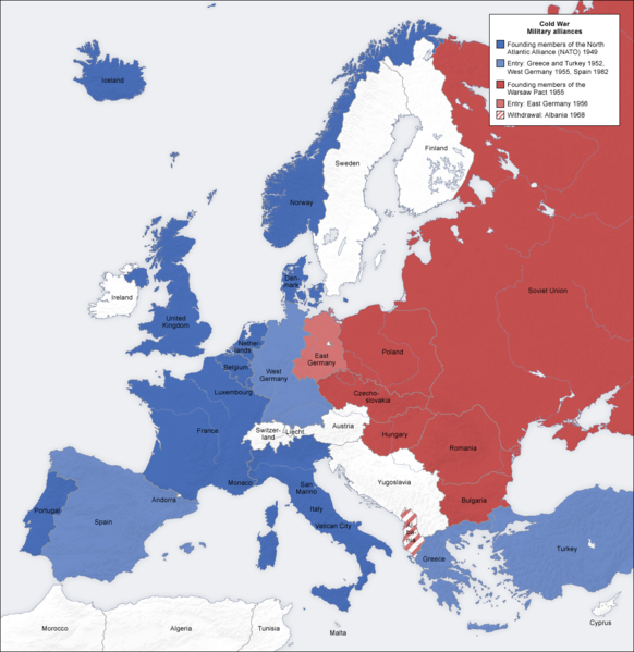
- Description: military alliances in the Cold war, map de
- Source: own map, based on the Generic Mapping Tools archive copy at the Wayback Machine and ETOPO2 archive copy at the Wayback Machine
- Author: San Jose, 7 October 2006
- Other versions: German, French, Classical Chinese, without text, Arabic
Hatimiliki
The map has been created with the Generic Mapping Tools: https://www.generic-mapping-tools.org/ using one or more of these public-domain datasets for the relief:
|

|
Ruhusa inakubalika kunakili, kusambaza na/au kurekebisha chini ya matakwa ya GNU Free Documentation License, Toleo 1.2 au toleo lolote lile la baadaye ambalo litachapishwa na Free Software Foundation; lisilo na Sehemu Tofauti, lisilo na Maandishi-Kava-Kwa-Mbele, na lisilo na Maandishi-Kava-Kwa -Nyuma. Nakala ya hatimiliki inajumlishwa kwenye sehemu ilioitwa GNU Free Documentation License. |
| Faili hii imeidhinishwa chini ya Creative Commons Attribution- Attribution-Share Alike 3.0 Unported leseni. | ||
shiriki sawa – Ukichanganya, kubadilisha, au kujenga juu ya nyenzo, lazima usambaze michango yako chini ya same or compatible license kama ya awali. | ||
| This licensing tag was added to this file as part of the GFDL licensing update. |
See also
_en.png)
.png)
.jpg)
Historia ya faili
Bonyeza tarehe/saa kuona faili kama ilivyoonekana wakati huo.
| Tarehe/Saa | Picha ndogo | Vipimo | Mtumiaji | Maelezo | |
|---|---|---|---|---|---|
| sasa hivi | 19:36, 20 Mei 2012 | | 1,165 × 1,200 (419 KB) | Patrickneil | Reverted to version as of 09:07, 12 June 2008, as requested on the Talk page |
| 12:39, 11 Aprili 2010 |  | 1,165 × 1,200 (415 KB) | IngerAlHaosului | fixed = west Berlin now light blue | |
| 09:07, 12 Juni 2008 |  | 1,165 × 1,200 (419 KB) | San Jose | update | |
| 14:55, 7 Oktoba 2006 |  | 1,165 × 1,200 (473 KB) | San Jose | upload |
Matumizi ya faili
Ukurasa huu umeunganishwa na faili hili:
Matumizi ya faili ulimwenguni
Wiki nyingine hutumia faili hizi:
- Matumizi kwa af.wikipedia.org
- Matumizi kwa ar.wikipedia.org
- Matumizi kwa ast.wikipedia.org
- Matumizi kwa azb.wikipedia.org
- Matumizi kwa az.wikipedia.org
- Matumizi kwa ba.wikipedia.org
- Matumizi kwa be.wikipedia.org
- Matumizi kwa bg.wikipedia.org
- Matumizi kwa bs.wikipedia.org
- Matumizi kwa ca.wikipedia.org
- Matumizi kwa cs.wikipedia.org
- Matumizi kwa cv.wikipedia.org
- Matumizi kwa da.wikipedia.org
- Matumizi kwa de.wikipedia.org
- Matumizi kwa el.wikipedia.org
- Matumizi kwa en.wikipedia.org
- Military alliance
- Cold War
- Foreign relations of the Soviet Union
- Bibliography of the Cold War
- Presidency of Harry S. Truman
- User:Aridd/Through the hidden door/Main
- User:Hires an editor/CWSandbox
- User:Eurocopter/Sandbox/Archive 1
- Khrushchev Thaw
- Foreign policy of the Harry S. Truman administration
- User:Falcaorib
- Matumizi kwa eu.wikipedia.org
- Matumizi kwa fa.wikipedia.org
- Matumizi kwa fi.wikipedia.org
- Matumizi kwa fr.wikipedia.org
- Matumizi kwa fy.wikipedia.org
- Matumizi kwa gl.wikipedia.org
- Matumizi kwa he.wikipedia.org
- Matumizi kwa hif.wikipedia.org
- Matumizi kwa ht.wikipedia.org
- Matumizi kwa hy.wikipedia.org
Tazama matumizi zaidi ya kimataifa ya faili hii.