
Faili:Caspian Sea from orbit-NoRedLines.jpg

Ukubwa wa hakikisho: piseli 471 × 599. Ukubwa zingine: piseli 188 × 240 | piseli 377 × 480 | piseli 603 × 768 | piseli 804 × 1,024 | piseli 1,609 × 2,048 | piseli 4,400 × 5,600.
Faili halisi (piseli 4,400 × 5,600, saizi ya faili: 9.04 MB, aina ya MIME: image/jpeg)
| Faili hili linatoka Wikimedia Commons. Maelezo yapo kule kwenye ukurasa wake wa maelezo unaonekana hapo chini.
|
|
| Maelezo |
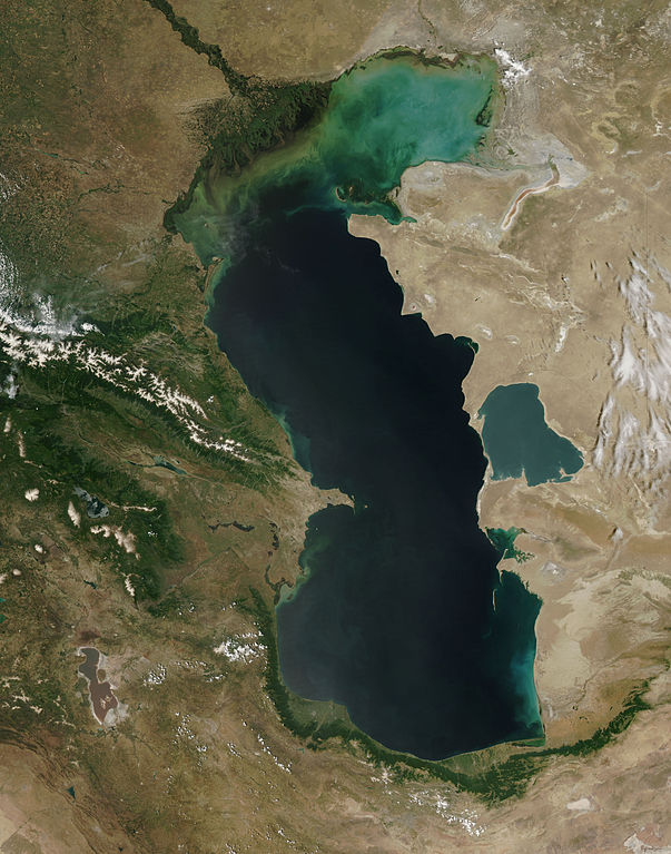
Español: El Mar Caspio visto desde la órbita terrestre English: This is a view from orbit of the Caspian Sea as imaged by the MODIS sensor on the Terra satellite. Caption: The original caption from NASA: ::"The northern part of the Caspian Sea is plagued by a process called eutrophication, in which agricultural run-off rich in fertilizers stimulates rampant growth of algae in the water. The death and decay of these algae robs the water of oxygen, with obvious negative consequences for aquatic life. This image of the Caspian Sea shows swirls of green and blue near the mouth of the Volga River (top center), which indicate the presence of algae. The bright blue color of the northeastern part of the sea may be due to a mixture of plant life and sediment, for this is where the sea is most shallow. This image is from the Moderate Resolution Imaging Spectroradiometer (MODIS) on the Terra satellite on June 11, 2003. |
| Tarehe | (UTC) |
| Chanzo | |
| Mwandishi |
|
| This is a retouched picture, which means that it has been digitally altered from its original version. Modifications: cloned out and healed little all the little red lines. The original can be viewed here: Caspian Sea from orbit.jpg:
|
| This file is in the public domain in the United States because it was solely created by NASA. NASA copyright policy states that "NASA material is not protected by copyright unless noted". (See Template:PD-USGov, NASA copyright policy page or JPL Image Use Policy.) | ||
 |
Warnings:
|
Kumbukumbu ya upakizaji wa asili
This image is a derivative work of the following images:
- File:Caspian_Sea_from_orbit.jpg licensed with PD-USGov-NASA
- 2010-06-14T09:16:01Z Originalwana 4400x5600 (3608474 Bytes) higher res
- 2005-02-08T15:10:25Z Pixeltoo 550x700 (68127 Bytes) Caspian sea by space [[Nasa]]
Uploaded with derivativeFX
Historia ya faili
Bonyeza tarehe/saa kuona faili kama ilivyoonekana wakati huo.
| Tarehe/Saa | Picha ndogo | Vipimo | Mtumiaji | Maelezo | |
|---|---|---|---|---|---|
| sasa hivi | 23:51, 2 Septemba 2010 | | 4,400 × 5,600 (9.04 MB) | IdLoveOne~commonswiki | cloning and healing |
| 16:19, 2 Septemba 2010 |  | 4,400 × 5,600 (9.04 MB) | IdLoveOne~commonswiki | more cleaning | |
| 16:07, 2 Septemba 2010 |  | 4,400 × 5,600 (9.04 MB) | IdLoveOne~commonswiki | cleaned more on lower left | |
| 15:46, 2 Septemba 2010 |  | 4,400 × 5,600 (9.04 MB) | IdLoveOne~commonswiki | {{Information |Description={{es|El '''Mar Caspio''' visto desde la órbita terrestre}} {{en|This is a view from orbit of the Caspian Sea as imaged by the MODIS sensor on the Terra satellite. '''Caption:''' The original caption from NASA: ::"The n |
Matumizi ya faili
Ukurasa huu umeunganishwa na faili hili:
Matumizi ya faili ulimwenguni
Wiki nyingine hutumia faili hizi:
- Matumizi kwa alt.wikipedia.org
- Matumizi kwa az.wikipedia.org
- Matumizi kwa ba.wikipedia.org
- Matumizi kwa ca.wikipedia.org
- Matumizi kwa ce.wikipedia.org
- Каспий-хӀорд
- Нохчийн гӀайре
- Кеп:Каспий-хӀордан гӀайренаш
- Адсыз ада
- Ӏашур-Ада
- Каспий-хӀордан гӀайренийн могӀам
- Кюр-Даши
- Хиль (гӀайре)
- Игнат даши
- Зенбиль
- ГӀум (гӀайре)
- Бёюк-Зиря
- Чигил
- Сенги-Муган
- Чилов гӀайре
- Яшма (гӀайре)
- Охана йаккхий гӀайренаш
- Джамбайн гӀайре
- Спиркин Осерёдок
- Тюленьи гӀайренаш
- Тюлений (Каспий-хӀорд)
- Верхни Осередок
- Нордови
- Чисти Банка
- Зюдев (гӀайре, Росси)
- Коневски
- Баткачни
- Лихачёв (гӀайре)
- Нижни (гӀайре)
- Мали Сетной
- Большой Сетной
- Мали Зюдостински
- Большой Зюдостински
- Огурджале
- Даш-Зиря
- Хере-Зиря
- Кюр-Дили
- Суатли адалари
- Гутан (гӀайре)
- Даш адалари
- Пираллахи (ахгӀайре)
- Бабурий
- Боьйуьк Тава
- Гарабаттаг (гӀайре)
- Гу (гӀайре)
- Дахили Даш
Tazama matumizi zaidi ya kimataifa ya faili hii.