
Faili:Byzantine Macedonia 1045CE.svg

Faili halisi (faili la SVG, husemwa kuwa piseli 423 × 335, saizi ya faili: 457 KB)
| Faili hili linatoka Wikimedia Commons. Maelezo yapo kule kwenye ukurasa wake wa maelezo unaonekana hapo chini.
|
Diese Karte stimmt nicht mit dem Historischen Atlas überein eine Fehlinformation.
Muhtasari
| Maelezo |
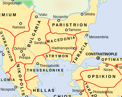
Català: Un mapa que mostra els temes bizantins (unitats administratives) de l'Imperi Bizantí l'any 1045 dC, centrat en els Balcans centrals al voltant de la regió de Macedònia. El tema macedoni es troba en el que avui forma part de l'actual Bulgària, mentre que el tema búlgar inclou el que avui és la República de Macedònia del Nord. Tingueu en compte que els límits temàtics d'aquest mapa, especialment els d'Estrímon i Macedònia, són molt inexactes. Macedònia es trobava realment més al sud, fins a la costa de l'Egeu de Tràcia occidental
English: A map showing the Byzantine themata (administrative units) of the Byzantine Empire in 1045 CE, focusing on central Balkans around the region of Macedonia. The Macedonian thema is in what today is part of present-day Bulgaria, while the Bulgarian thema includes what today is the Republic of North Macedonia. Note that the thematic boundaries in this map, especially those of Strymon and Macedonia, are very inaccurate. Macedonia was actually located further south, up to the Aegean coast of western Thrace |
| Tarehe | |
| Chanzo | This is a derivative work of a more complete map created by ArdadN of the English Wikipedia. |
| Mwandishi | NerdyNSK |
| Ruhusa (Kutumia faili tena) |
GFDL-1.2+, CC-BY-SA-3.0/2.5/2.0/1.0 |
| Matoleo mengine |
This is a derivative work of a more complete map created by ArdadN of the English Wikipedia. File:Byzantine Macedonia 1045CE.svg has 2 translations.
Other related versions: []
|


|
This SVG file contains embedded text that can be translated into your language, using any capable SVG editor, text editor or the SVG Translate tool. For more information see: About translating SVG files. |
This file is translated using SVG <switch> elements. All translations are stored in the same file! Learn more.
For most Wikipedia projects, you can embed the file normally (without a To translate the text into your language, you can use the SVG Translate tool. Alternatively, you can download the file to your computer, add your translations using whatever software you're familiar with, and re-upload it with the same name. You will find help in Graphics Lab if you're not sure how to do this. |
Hatimiliki

|
Ruhusa inakubalika kunakili, kusambaza na/au kurekebisha chini ya matakwa ya GNU Free Documentation License, Toleo 1.2 au toleo lolote lile la baadaye ambalo litachapishwa na Free Software Foundation; lisilo na Sehemu Tofauti, lisilo na Maandishi-Kava-Kwa-Mbele, na lisilo na Maandishi-Kava-Kwa -Nyuma. Nakala ya hatimiliki inajumlishwa kwenye sehemu ilioitwa GNU Free Documentation License. |
- Uko huru:
- kushiriki – kunakili na kusambaza kazi hiyo
- kwa remix – kurekebisha kazi
- Chini ya masharti yafuatayo:
- sifa – Ni lazima utoe mkopo unaofaa, utoe kiungo cha leseni, na uonyeshe ikiwa mabadiliko yalifanywa. Unaweza kufanya hivyo kwa njia yoyote inayofaa, lakini si kwa njia yoyote inayopendekeza mtoa leseni akuidhinishe wewe au matumizi yako.
Historia ya faili
Bonyeza tarehe/saa kuona faili kama ilivyoonekana wakati huo.
| Tarehe/Saa | Picha ndogo | Vipimo | Mtumiaji | Maelezo | |
|---|---|---|---|---|---|
| sasa hivi | 16:05, 11 Februari 2024 | | 423 × 335 (457 KB) | Manlleus | File uploaded using svgtranslate tool (https://svgtranslate.toolforge.org/). Added translation for ca. |
| 07:58, 10 Februari 2024 |  | 423 × 335 (457 KB) | Leptictidium | File uploaded using svgtranslate tool (https://svgtranslate.toolforge.org/). Added translation for ca. | |
| 07:50, 10 Februari 2024 |  | 423 × 335 (457 KB) | Leptictidium | File uploaded using svgtranslate tool (https://svgtranslate.toolforge.org/). Added translation for ca. | |
| 19:52, 9 Februari 2024 |  | 423 × 335 (447 KB) | Manlleus | added catalan language | |
| 21:30, 4 Mei 2017 |  | 423 × 335 (407 KB) | Kandi | Reverted to version as of 05:00, 4 April 2008 (UTC) | |
| 21:15, 4 Mei 2017 |  | 4,252 × 6,013 (317 KB) | Kandi | new, more detailed version | |
| 05:00, 4 Aprili 2008 |  | 423 × 335 (407 KB) | NerdyNSK | {{Information |Description=A map showing the Byzantine themata (administrative units) of the Byzantine Empire in 1045 CE, focusing on central Balkans around the region of Macedonia. The Macedonian thema is in what today is part of present-day Bulgaria, w |
Matumizi ya faili
Ukurasa huu umeunganishwa na faili hili:
Matumizi ya faili ulimwenguni
Wiki nyingine hutumia faili hizi:
- Matumizi kwa als.wikipedia.org
- Matumizi kwa ar.wikipedia.org
- Matumizi kwa azb.wikipedia.org
- Matumizi kwa ba.wikipedia.org
- Matumizi kwa be.wikipedia.org
- Matumizi kwa bg.wikipedia.org
- Matumizi kwa ca.wikipedia.org
- Matumizi kwa cs.wikipedia.org
- Matumizi kwa de.wikipedia.org
- Matumizi kwa el.wikipedia.org
- Matumizi kwa en.wikipedia.org
- Matumizi kwa fr.wikipedia.org
Tazama matumizi zaidi ya kimataifa ya faili hii.