
Faili:Arctic.svg

Size of this PNG preview of this SVG file: piseli 478 × 599. Ukubwa zingine: piseli 191 × 240 | piseli 383 × 480 | piseli 613 × 768 | piseli 817 × 1,024 | piseli 1,634 × 2,048 | piseli 505 × 633.
Faili halisi (faili la SVG, husemwa kuwa piseli 505 × 633, saizi ya faili: 1.5 MB)
| Faili hili linatoka Wikimedia Commons. Maelezo yapo kule kwenye ukurasa wake wa maelezo unaonekana hapo chini.
|
Muhtasari
| Maelezo |
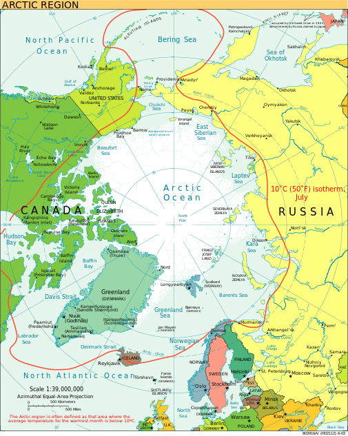
English: A view of the Arctic. The 10 °C (50 °F) mean isotherm in July line, displayed red, is commonly used to define the border of the Arctic region. |
| Tarehe | Februari 2013 (original upload date) |
| Chanzo | CIA World Factbook |
| Mwandishi | CIA World Factbook |
| Matoleo mengine |
[]
|


.svg)


|
This SVG file contains embedded text that can be translated into your language, using any capable SVG editor, text editor or the SVG Translate tool. For more information see: About translating SVG files. |
Hatimiliki
This image is in the public domain because it contains materials that originally came from the United States Central Intelligence Agency's World Factbook.
|
 |
Historia ya faili
Bonyeza tarehe/saa kuona faili kama ilivyoonekana wakati huo.
| Tarehe/Saa | Picha ndogo | Vipimo | Mtumiaji | Maelezo | |
|---|---|---|---|---|---|
| sasa hivi | 21:00, 11 Agosti 2023 | | 505 × 633 (1.5 MB) | Mahagaja | correct spelling of Kangiqliniq |
| 18:29, 9 Agosti 2009 |  | 505 × 633 (1.5 MB) | Ysangkok | compact code, no visible changes afaik | |
| 23:34, 19 Agosti 2007 |  | 505 × 633 (1.63 MB) | StephenHudson | Reverted to earlier revision | |
| 22:18, 19 Agosti 2007 |  | 1,010 × 1,267 (1.4 MB) | StephenHudson | Increased base pixel size to make text readable. | |
| 17:17, 24 Januari 2006 |  | 505 × 633 (1.63 MB) | Moyogo | stripped useless stuff | |
| 20:32, 23 Januari 2006 |  | 505 × 633 (1.95 MB) | Sanao | Arctic<br /> Origin : CIA World Factbook Category:SVG maps Category:Arctic |
Matumizi ya faili
Ukurasa huu umeunganishwa na faili hili:
Matumizi ya faili ulimwenguni
Wiki nyingine hutumia faili hizi:
- Matumizi kwa ace.wikipedia.org
- Matumizi kwa ady.wikipedia.org
- Matumizi kwa af.wikipedia.org
- Matumizi kwa ar.wikipedia.org
- Matumizi kwa arz.wikipedia.org
- Matumizi kwa ast.wikipedia.org
- Matumizi kwa as.wikipedia.org
- Matumizi kwa ba.wikipedia.org
- Matumizi kwa bg.wikipedia.org
- Matumizi kwa bn.wikipedia.org
- Matumizi kwa ca.wikipedia.org
- Matumizi kwa cy.wikipedia.org
- Matumizi kwa da.wikipedia.org
- Matumizi kwa da.wiktionary.org
- Matumizi kwa de.wikipedia.org
- Matumizi kwa dty.wikipedia.org
- Matumizi kwa el.wikipedia.org
- Matumizi kwa en.wikipedia.org
- Geography of Denmark
- Jan Mayen
- Svalbard
- Northern Canada
- History of Svalbard
- Contour line
- List of rivers of the Americas by coastline
- Arctic Bridge
- History of the petroleum industry in Canada (frontier exploration and development)
- Portal:Maps/Maps/Nautical
- Portal:Maps/Maps/Nautical/2
- Arctic Ocean
- Wikipedia:Graphics Lab/Map workshop/Archive/Aug 2009
- Sir James Lamont, 1st Baronet
- Arctic exploration
- Portal:Oceans
- Matumizi kwa en.wikibooks.org
- Matumizi kwa eo.wikipedia.org
- Matumizi kwa eo.wiktionary.org
Tazama matumizi zaidi ya kimataifa ya faili hii.