
Faili:Topographic map of Gotland.svg

Size of this PNG preview of this SVG file: piseli 491 × 599. Ukubwa zingine: piseli 197 × 240 | piseli 393 × 480 | piseli 629 × 768 | piseli 839 × 1,024 | piseli 1,678 × 2,048 | piseli 1,337 × 1,632.
Faili halisi (faili la SVG, husemwa kuwa piseli 1,337 × 1,632, saizi ya faili: 1.16 MB)
| Faili hili linatoka Wikimedia Commons. Maelezo yapo kule kwenye ukurasa wake wa maelezo unaonekana hapo chini.
|
Muhtasari
This W3C-unspecified vector image was created with Inkscape .
| Maelezo |
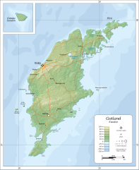
English: Topographic map of Gotland.
Suomi: Gotlannin topografinen kartta.
Svenska: En topografisk karta över Gotland. |
| Tarehe | |
| Chanzo |
Self-made in Inkscape.
|
| Mwandishi | Oona Räisänen (Mysid) |
| Matoleo mengine |
|


|
This SVG file contains embedded text that can be translated into your language, using any capable SVG editor, text editor or the SVG Translate tool. For more information see: About translating SVG files. |
Hatimiliki
I, the copyright holder of this work, hereby publish it under the following licenses:

|
Ruhusa inakubalika kunakili, kusambaza na/au kurekebisha chini ya matakwa ya GNU Free Documentation License, Toleo 1.2 au toleo lolote lile la baadaye ambalo litachapishwa na Free Software Foundation; lisilo na Sehemu Tofauti, lisilo na Maandishi-Kava-Kwa-Mbele, na lisilo na Maandishi-Kava-Kwa -Nyuma. Nakala ya hatimiliki inajumlishwa kwenye sehemu ilioitwa GNU Free Documentation License. |
This file is licensed under the Creative Commons Attribution-Share Alike 4.0 International, 3.0 Unported, 2.5 Generic, 2.0 Generic and 1.0 Generic license.
- Uko huru:
- kushiriki – kunakili na kusambaza kazi hiyo
- kwa remix – kurekebisha kazi
- Chini ya masharti yafuatayo:
- sifa – Ni lazima utoe mkopo unaofaa, utoe kiungo cha leseni, na uonyeshe ikiwa mabadiliko yalifanywa. Unaweza kufanya hivyo kwa njia yoyote inayofaa, lakini si kwa njia yoyote inayopendekeza mtoa leseni akuidhinishe wewe au matumizi yako.
Unaweza kuchagua leseni ya chaguo lako.
Historia ya faili
Bonyeza tarehe/saa kuona faili kama ilivyoonekana wakati huo.
| Tarehe/Saa | Picha ndogo | Vipimo | Mtumiaji | Maelezo | |
|---|---|---|---|---|---|
| sasa hivi | 19:29, 6 Agosti 2010 | | 1,337 × 1,632 (1.16 MB) | Mysid | fonts with better support |
| 19:25, 6 Agosti 2010 |  | 1,337 × 1,632 (1.16 MB) | Mysid | major remake from better sources | |
| 13:39, 8 Julai 2008 |  | 635 × 1,023 (499 KB) | Smith609 | Correct spelling of BurgsviK | |
| 17:43, 25 Februari 2008 |  | 635 × 1,023 (491 KB) | Mysid | roads | |
| 16:10, 24 Februari 2008 |  | 635 × 1,023 (482 KB) | Mysid | {{inkscape}} {{Information |Description={{en|Topographic map of w:Gotland.}} {{fi|Gotlannin topografinen kartta.}} {{sv|En topografisk karta över sv:Gotland.}} |Source=Self-made in Inkscape.<br/>Boundaries and topography based |
Matumizi ya faili
Ukurasa huu umeunganishwa na faili hili:
Matumizi ya faili ulimwenguni
Wiki nyingine hutumia faili hizi:
- Matumizi kwa ar.wikipedia.org
- Matumizi kwa ast.wikipedia.org
- Matumizi kwa az.wikipedia.org
- Matumizi kwa be-tarask.wikipedia.org
- Matumizi kwa be.wikipedia.org
- Matumizi kwa ce.wikipedia.org
- Matumizi kwa cs.wikipedia.org
- Matumizi kwa dsb.wikipedia.org
- Matumizi kwa el.wikipedia.org
- Matumizi kwa en.wikipedia.org
- Matumizi kwa es.wikipedia.org
- Matumizi kwa fi.wikipedia.org
- Matumizi kwa fr.wikipedia.org
- Matumizi kwa fy.wikipedia.org
- Matumizi kwa gl.wikipedia.org
- Matumizi kwa hu.wikipedia.org
- Matumizi kwa is.wikipedia.org
- Matumizi kwa ja.wikipedia.org
- Matumizi kwa ko.wikipedia.org
- Matumizi kwa lt.wikipedia.org
- Matumizi kwa mn.wikipedia.org
- Matumizi kwa ms.wikipedia.org
- Matumizi kwa os.wikipedia.org
- Matumizi kwa pl.wikipedia.org
- Matumizi kwa pl.wiktionary.org
- Matumizi kwa ru.wikipedia.org
- Matumizi kwa sr.wikipedia.org
- Matumizi kwa sv.wikipedia.org
- Matumizi kwa vls.wikipedia.org