
Faili:Strait of Gibraltar perspective.jpg

Ukubwa wa hakikisho: piseli 800 × 480. Ukubwa zingine: piseli 320 × 192 | piseli 1,024 × 615 | piseli 1,528 × 917.
Faili halisi (piseli 1,528 × 917, saizi ya faili: 182 KB, aina ya MIME: image/jpeg)
| Faili hili linatoka Wikimedia Commons. Maelezo yapo kule kwenye ukurasa wake wa maelezo unaonekana hapo chini.
|
Muhtasari
| Maelezo |
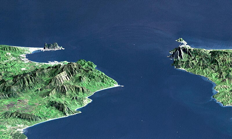
English: "This perspective view shows the Strait of Gibraltar, which is the entrance to the Mediterranean Sea from the Atlantic Ocean, with a 3-times vertical exaggeration to enhance topographic expression. Europe (Spain) is on the left. Africa (Morocco) is on the right. The Rock of Gibraltar, administered by Great Britain, is the peninsula in the back left." (quotation taken from the more detailed NASA description page)
Deutsch: Straße von Gibraltar; Aufnahme der NASA dreifach überhöht. Erstellt aus Daten von SRTM und Landsat
Français : Vue en perspective du détroit de Gibraltar ouvrant sur la mer Mediterranée avec le Maroc à droite et l'Espagne a gauche. coté espagnol on remarque le rocher de Gibraltar, en face le petit rocher est Ceuta, territoire espagnol en terre africaine.
Español: Peñón de Gibraltar |
| Tarehe |
|
| Chanzo | http://photojournal.jpl.nasa.gov/catalog/PIA03397 |
| Mwandishi | NASA / JPL / NIMA |
| Matoleo mengine |
Derivative works of this file: |
Hatimiliki
| This file is in the public domain in the United States because it was solely created by NASA. NASA copyright policy states that "NASA material is not protected by copyright unless noted". (See Template:PD-USGov, NASA copyright policy page or JPL Image Use Policy.) | ||
 |
Warnings:
|
| Annotations | This image is annotated: View the annotations at Commons |
Historia ya faili
Bonyeza tarehe/saa kuona faili kama ilivyoonekana wakati huo.
| Tarehe/Saa | Picha ndogo | Vipimo | Mtumiaji | Maelezo | |
|---|---|---|---|---|---|
| sasa hivi | 00:20, 14 Novemba 2005 | | 1,528 × 917 (182 KB) | Oxam Hartog | en : Perspective view from the Strait of Gibraltar, Marocco is on rigth, Spain on left with the Rock of Gibraltar ahead on left. On the other side the little rock is Ceuta Spain territory on african continent fr: Vue en perspective du detroit de Gibaltar |
Matumizi ya faili
Ukurasa huu umeunganishwa na faili hili:
Matumizi ya faili ulimwenguni
Wiki nyingine hutumia faili hizi:
- Matumizi kwa af.wikipedia.org
- Matumizi kwa ar.wikipedia.org
- Matumizi kwa azb.wikipedia.org
- Matumizi kwa az.wikipedia.org
- Matumizi kwa be.wikipedia.org
- Matumizi kwa bo.wikipedia.org
- Matumizi kwa br.wikipedia.org
- Matumizi kwa bs.wikipedia.org
- Matumizi kwa ca.wikipedia.org
- Matumizi kwa ckb.wikipedia.org
- Matumizi kwa de.wikipedia.org
- Matumizi kwa de.wiktionary.org
- Matumizi kwa en.wikipedia.org
- Matumizi kwa en.wikivoyage.org
- Matumizi kwa es.wikipedia.org
- Matumizi kwa et.wikipedia.org
- Matumizi kwa frr.wikipedia.org
- Matumizi kwa fr.wikipedia.org
- Matumizi kwa ja.wikipedia.org
- Matumizi kwa ka.wikipedia.org
- Matumizi kwa kbd.wikipedia.org
- Matumizi kwa ky.wikipedia.org
- Matumizi kwa lt.wikipedia.org
- Matumizi kwa mt.wikipedia.org
- Matumizi kwa nl.wikipedia.org
- Matumizi kwa pl.wiktionary.org
- Matumizi kwa pt.wikipedia.org
- Matumizi kwa ro.wikipedia.org
- Matumizi kwa ru.wikipedia.org
- Matumizi kwa ru.wiktionary.org
- Matumizi kwa sl.wikipedia.org
- Matumizi kwa uk.wikipedia.org
- Matumizi kwa uz.wikipedia.org
Tazama matumizi zaidi ya kimataifa ya faili hii.