
Faili:Republique centrafricaine carte.gif
Hakuna saizi kubwa zaidi.
Republique_centrafricaine_carte.gif (piseli 326 × 350, saizi ya faili: 22 KB, aina ya MIME: image/gif)
| Faili hili linatoka Wikimedia Commons. Maelezo yapo kule kwenye ukurasa wake wa maelezo unaonekana hapo chini.
|
Muhtasari

|
This locator map image could be re-created using vector graphics as an SVG file. This has several advantages; see Commons:Media for cleanup for more information. If an SVG form of this image is available, please upload it and afterwards replace this template with
{{vector version available|new image name}}.
It is recommended to name the SVG file “Republique centrafricaine carte.svg”—then the template Vector version available (or Vva) does not need the new image name parameter. |

|
This map has been uploaded by Electionworld from fr.wikipedia.org to enable the |
| Maelezo |
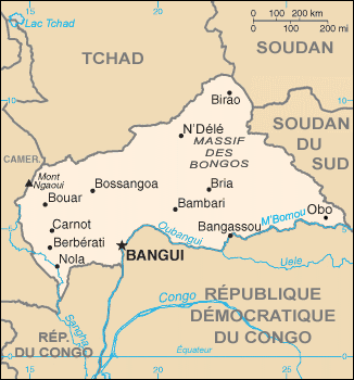
Carte de la fr:République centrafricaine
|
| Tarehe | 25 Oktoba 2005 (original upload date) |
| Chanzo | Transferred from fr.wikipedia to Commons. |
| Mwandishi | The original uploader was Sting at Kifaransa Wikipedia. |
Hatimiliki
This image is in the public domain because it contains materials that originally came from the United States Central Intelligence Agency's World Factbook.
|
 |
Kumbukumbu ya upakizaji wa asili
The original description page was here. All following user names refer to fr.wikipedia.
- 2005-10-25 00:37 Sting 326×350×8 (15910 bytes) Carte de la [[République centrafricaine]] * Source : [https://www.cia.gov/library/publications/the-world-factbook/ CIA World Factbook] ; * D'après un chargement de [[Utilisateur:Rinaldum]]. {{DomainePublic}}
Historia ya faili
Bonyeza tarehe/saa kuona faili kama ilivyoonekana wakati huo.
| Tarehe/Saa | Picha ndogo | Vipimo | Mtumiaji | Maelezo | |
|---|---|---|---|---|---|
| sasa hivi | 10:23, 31 Desemba 2013 | | 326 × 350 (22 KB) | Naturals | add borders of South Sudan |
| 19:39, 24 Machi 2013 |  | 326 × 350 (16 KB) | Drongou | Undo revision 92688621 by Edoardo Cavaleri (talk) thanks for borders but english version is on File:Central African Republic-CIA WFB Map.png | |
| 16:20, 16 Machi 2013 |  | 328 × 352 (21 KB) | Edoardo Cavaleri | South Sudan and English language | |
| 23:27, 24 Januari 2007 |  | 326 × 350 (16 KB) | Electionworld | {{ew|fr|Sting}} {{Information |Description=Carte de la fr:République centrafricaine * Source : [http://www.cia.gov/cia/publications/factbook/ CIA World Factbook] ; * D'après un chargement de fr:Utilisateur:Rinaldum. |Source=Originally from [ |
Matumizi ya faili
Hakuna kurasa zozote zinazotumia faili hii.
Matumizi ya faili ulimwenguni
Wiki nyingine hutumia faili hizi:
- Matumizi kwa fr.wikipedia.org
- Matumizi kwa fr.wikinews.org
- Matumizi kwa it.wikipedia.org
- Matumizi kwa kg.wikipedia.org
- Matumizi kwa la.wikipedia.org
- Matumizi kwa ln.wikipedia.org
- Matumizi kwa mg.wikipedia.org
- Matumizi kwa ms.wikipedia.org
- Matumizi kwa oc.wikipedia.org
- Matumizi kwa scn.wikipedia.org
- Matumizi kwa sg.wikipedia.org
- Matumizi kwa vec.wikipedia.org
- Matumizi kwa vi.wikipedia.org