
Faili:Map of Oregon NA.png

Ukubwa wa hakikisho: piseli 800 × 541. Ukubwa zingine: piseli 320 × 217 | piseli 640 × 433 | piseli 1,024 × 693 | piseli 1,280 × 866 | piseli 1,967 × 1,331.
Faili halisi (piseli 1,967 × 1,331, saizi ya faili: 2.15 MB, aina ya MIME: image/png)
| Faili hili linatoka Wikimedia Commons. Maelezo yapo kule kwenye ukurasa wake wa maelezo unaonekana hapo chini.
|
Muhtasari
| Maelezo |
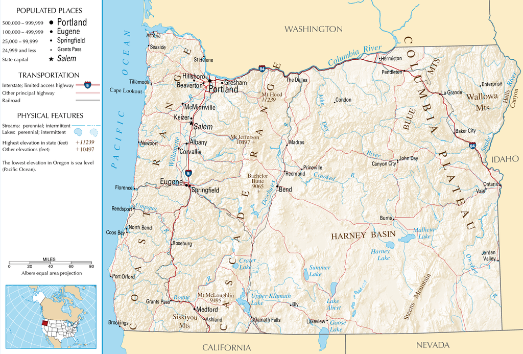
English: Topographic map of the geography of Oregon — with major rivers shown.
|
| Chanzo | National Atlas |
| Mwandishi | Unknown author |
Hatimiliki
This map was obtained from an edition of the National Atlas of the United States. Like almost all works of the U.S. federal government, works from the National Atlas are in the public domain in the United States.
Online access: NationalAtlas.gov | 1970 print edition: Library of Congress, Perry-Castañeda Library
|
Historia ya faili
Bonyeza tarehe/saa kuona faili kama ilivyoonekana wakati huo.
| Tarehe/Saa | Picha ndogo | Vipimo | Mtumiaji | Maelezo | |
|---|---|---|---|---|---|
| sasa hivi | 05:46, 16 Oktoba 2007 | | 1,967 × 1,331 (2.15 MB) | Peteforsyth | removed extraneous text and logo from public domain image |
| 08:13, 15 Agosti 2006 |  | 2,122 × 1,640 (2.75 MB) | Huebi~commonswiki | {{Information| |Description=Map of Oregon |Source=[http://www.nationalatlas.gov National Atlas] }} Category:Maps of the United States Category:Maps of Oregon {{PD-USGov-Atlas}} |
Matumizi ya faili
Ukurasa huu umeunganishwa na faili hili:
Matumizi ya faili ulimwenguni
Wiki nyingine hutumia faili hizi:
- Matumizi kwa als.wikipedia.org
- Matumizi kwa ar.wikipedia.org
- Matumizi kwa de.wikipedia.org
- Matumizi kwa en.wikipedia.org
- Matumizi kwa eo.wikipedia.org
- Matumizi kwa fi.wikipedia.org
- Matumizi kwa fr.wikipedia.org
- Matumizi kwa hr.wiktionary.org
- Matumizi kwa hsb.wikipedia.org
- Matumizi kwa hu.wikipedia.org
- Matumizi kwa incubator.wikimedia.org
- Matumizi kwa is.wikipedia.org
- Matumizi kwa it.wikipedia.org
- Matumizi kwa ja.wikipedia.org
- Matumizi kwa kk.wikipedia.org
- Matumizi kwa lt.wikipedia.org
- Matumizi kwa mr.wikipedia.org
- Matumizi kwa nds-nl.wikipedia.org
- Matumizi kwa pa.wikipedia.org
- Matumizi kwa ru.wikipedia.org
- Matumizi kwa vi.wikipedia.org
- Matumizi kwa zea.wikipedia.org