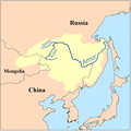
Faili:Amur watershed.png
Amur_watershed.png (piseli 500 × 500, saizi ya faili: 88 KB, aina ya MIME: image/png)
Historia ya faili
Bonyeza tarehe/saa kuona faili kama ilivyoonekana wakati huo.
| Tarehe/Saa | Picha ndogo | Vipimo | Mtumiaji | Maelezo | |
|---|---|---|---|---|---|
| sasa hivi | 18:37, 21 Februari 2022 |  | 500 × 500 (88 KB) | Geographyinitiative | Reverted to version as of 19:06, 3 February 2009 (UTC) Basis: The additional language information is not necessary. It is absolutely and utterly disastrous to label Mongolia with the languages of its superpower neighbors but not label Mongolia with its own language. Disgusting. Furthermore, areas outside Russian control are labeled in Russian and areas outside Chinese control are labeled in Chinese characters. The impression is one of great power game between superpowers. Also, the ROC Taiwan... |
| 03:30, 16 Julai 2016 |  | 500 × 500 (94 KB) | Whisper of the heart | Correction | |
| 03:25, 16 Julai 2016 |  | 500 × 500 (94 KB) | Whisper of the heart | / | |
| 08:38, 5 Mei 2013 |  | 500 × 500 (110 KB) | Someone's Moving Castle | Correct Info | |
| 19:52, 27 Aprili 2013 |  | 500 × 500 (99 KB) | Someone's Moving Castle | More Language | |
| 19:45, 27 Aprili 2013 |  | 500 × 500 (98 KB) | Someone's Moving Castle | More Language | |
| 19:06, 3 Februari 2009 |  | 500 × 500 (88 KB) | Kmusser | Corrected watershed boundary and Shilka | |
| 18:28, 1 Aprili 2008 |  | 300 × 301 (50 KB) | Kmusser | added labels for tribs | |
| 12:54, 11 Aprili 2006 |  | 300 × 300 (16 KB) | Kmusser | ||
| 12:49, 11 Aprili 2006 |  | 200 × 200 (10 KB) | Kmusser | This is a map of the Amur River Watershed. I, Karl Musser, created it based on USGS data. {{GFDL}} Category:Maps of rivers |
Matumizi ya faili
Ukurasa huu umeunganishwa na faili hili:
Matumizi ya faili ulimwenguni
Wiki nyingine hutumia faili hizi:
- Matumizi kwa af.wikipedia.org
- Matumizi kwa ar.wikipedia.org
- Matumizi kwa ary.wikipedia.org
- Matumizi kwa arz.wikipedia.org
- Matumizi kwa azb.wikipedia.org
- Matumizi kwa be-tarask.wikipedia.org
- Matumizi kwa ceb.wikipedia.org
- Matumizi kwa cs.wikipedia.org
- Matumizi kwa da.wikipedia.org
- Matumizi kwa de.wikipedia.org
- Matumizi kwa en.wikipedia.org
- Matumizi kwa en.wiktionary.org
- Matumizi kwa eo.wikipedia.org
- Matumizi kwa fa.wikipedia.org
- Matumizi kwa fi.wikipedia.org
- Matumizi kwa fi.wiktionary.org
- Matumizi kwa fr.wikipedia.org
- Matumizi kwa fr.wiktionary.org
- Matumizi kwa gl.wikipedia.org
- Matumizi kwa hi.wikipedia.org
- Matumizi kwa hr.wikipedia.org
- Matumizi kwa hu.wikipedia.org
- Matumizi kwa id.wikipedia.org
- Matumizi kwa it.wikipedia.org
- Matumizi kwa ja.wikipedia.org
Tazama matumizi zaidi ya kimataifa ya faili hii.

